
Growing tall trees to provide shade for cocoa plantations in west Africa could sequester millions of tonnes of carbon, according to a new study.
The research, published in Nature Sustainability, finds that the additional carbon stored in shade trees, such as banana and palm trees, could entirely “offset” cocoa-related emissions in Ghana and Ivory Coast, without reducing production.
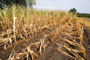
West Africa produces about 60% of the world’s cocoa, which is one of the most emissions-intensive crops to grow.
The authors map the shade provided by trees across cocoa agricultural systems in west Africa, then project how much additional carbon storage would be created by expanding it.
An author of the study tells Carbon Brief that cocoa plantations have been a “big” driver of deforestation and the emissions it causes, but the findings show that there is “huge potential” for cocoa to be “part of the solution”.
Cocoa plantations
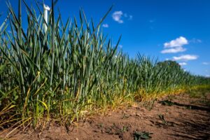
Cocoa trees thrive in rainforests, as they need abundant rain, high humidity and stable temperatures. They often grow under the shadow of other plants, such as bananas, plantains and palm trees.
Two countries in west Africa – Ivory Coast and Ghana – dominate global cocoa production and are major exporters to the US and Europe.
The shading on the map below shows where cocoa is grown in Ivory Coast (left) and Ghana (right).
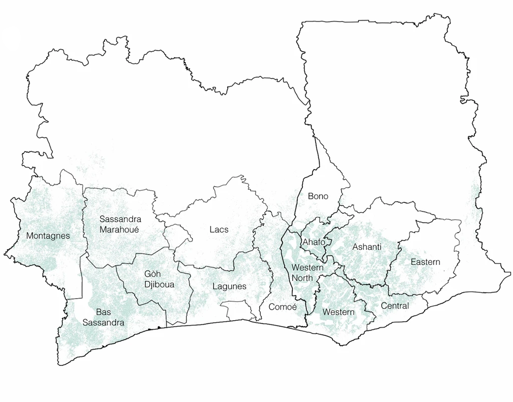
Both countries have favourable conditions for cocoa production, including tropical forests – which provide nutrients to the soil – a great deal of rain, warm temperatures and low production costs.
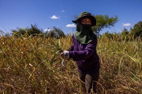
Two million farmers in the region rely on cocoa farming for their livelihoods, the study says, and cocoa contributes 10-20% of the two countries’ gross domestic product.
However, cocoa has “one of the most emissions-intensive footprints of all foods”, the study adds.
A 2022 study found that producing 1kg of cacao beans in Ivory Coast releases, on average, 1.5kg of CO2-equivalent (CO2e) – largely a result of deforestation. Since 2000, cocoa plantations have driven 37% of forest loss in protected areas in Ivory Coast and 13% of the loss in protected areas in Ghana.
Cocoa plantations cover more than three-and-a-half times as much land as the remaining intact forests in west Africa, according to the study.
Dr Wilma Blaser Hart, a research fellow at the University of Queensland and an author of the study, tells Carbon Brief:
“That land-use change is what makes cocoa such a carbon-intensive product, because there has just been so much forest loss for being able to produce cocoa.”
Shade-grown cocoa crops
Agroforestry is an agricultural method that combines the planting of crops with trees. Agroforestry can raise incomes for farmers and provide ecosystem services, including soil health improvement, biodiversity conservation and carbon sequestration.
The study investigates the amount of carbon that is currently stored in cocoa plantations in Ivory Coast and Ghana, as well as the potential carbon sequestration if agroforestry were expanded in these countries.
The authors use drones and machine learning to map the cover of shade trees, finding that 13% of the combined area of Ivory Coast and Ghana is currently covered with these trees.
In the study, “shade trees” refers to any trees taller than eight metres – the maximum height of cocoa trees.
The map below shows the area of shade trees in cocoa-growing areas specifically for 2022. The colours indicate levels of tree cover from 0-15% (blue), through to 15-30% (green) and more than 30% (yellow).
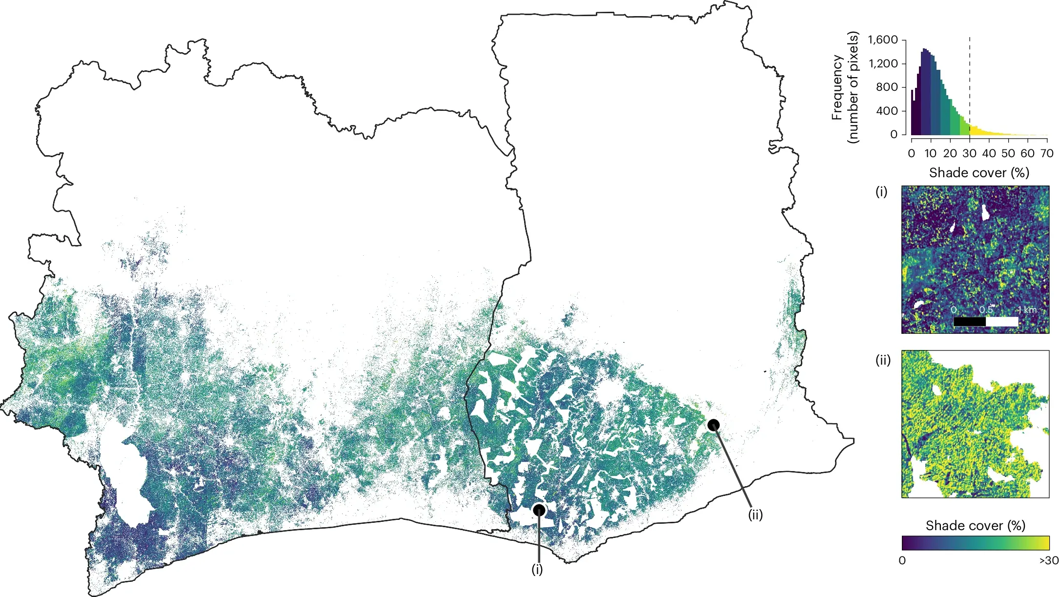
The map reveals that cocoa production is “overwhelmingly dominated by full-sun monocultures and low shade-agroforestry”, the study says.
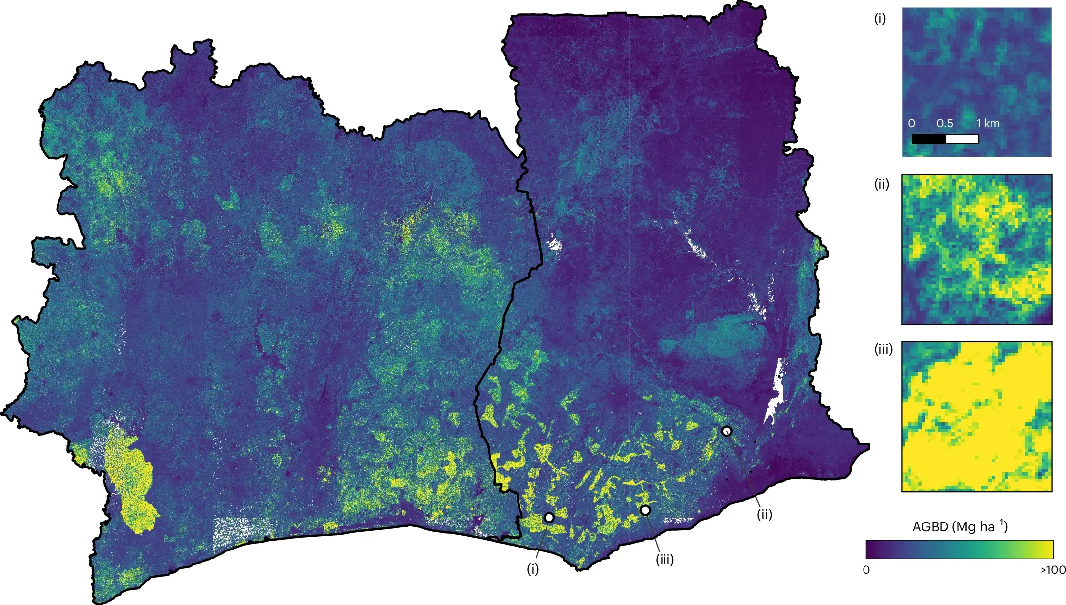
Using satellite data, global maps of tree canopy height and on-ground verification, the researchers map the amount of “aboveground biomass” held by cocoa plantations.
Aboveground biomass comprises all living vegetation that lies above the soil – trees, leaves and other plant matter.
The map below shows the amount of aboveground biomass in both countries. The areas in yellow are those with the highest biomass and, therefore, more stored carbon.
The authors project that if all cocoa plantations increased their cover of shade trees to at least 30%, the additional, taller trees could sequester an “enormous” amount of carbon – 307m tonnes of CO2e (MtCO2e) – enough to fully counterbalance the current cocoa-related emissions in both countries, without reducing production.
Blaser Hart tells Carbon Brief:
“Cocoa itself is a small tree. [It] can grow up to about eight metres tall, so it also sequesters carbon. [But] we found that tall trees that are towering high above cocoa – often timber trees – sequester much more carbon than cocoa.”
In addition, she says, the cover from large trees is “much better for cocoa” since it protects them during the hottest hours of the day, while allowing light through. They also shed large amounts of “litter”, which gets incorporated as organic matter into the soil, sequestering carbon from the atmosphere.
Barriers and limitations
The authors acknowledge several limitations to their study.
For example, they say, the analysis may underestimate the proportion of shade tree cover by excluding trees shorter than eight metres. They also note that the analysis does not consider all of the features of agroforestry systems, such as which species are planted.
Kayeli Laurence is a PhD student of landscape ecology at Jean Lorougnon Guédé University in Ivory Coast and an expert in agroforestry. The researcher, who was not involved in the study, tells Carbon Brief:
“The identified limitations call for caution, particularly when it comes to local, small-scale analyses. However, they do not undermine the general trends highlighted by the study.”
Laurence notes that the study results are consistent with other research highlighting the carbon sequestration potential of agroforestry systems. She says that the projection of carbon sequestration is “ambitious, but credible”. However, she adds:
“In practice, achieving this goal will strongly depend on local conditions: availability of species, technical support, farmers’ willingness and, above all, economic incentives.”
The study also acknowledges that smallholder farmers in west Africa “face several barriers” to adopting agroforestry, including limited incentives and insecure land tenure.
The non-profit scientific research organisation Project Drawdown notes that implementing a certain category of agroforestry called “multistrata” – a combination of long-lasting crops and multiple layers of trees or vegetation – in humid tropical climates would cost more than $1,300 per hectare.
Blaser Hart tells Carbon Brief:
“That’s a huge cost. And it’s not money that farmers have available.”
International landscape
Blaser Hart says that cocoa agroforestry provides further benefits to ecosystems, besides carbon sequestration. These include cooling the air, improving soil fertility and nutrient cycling and providing habitat for wildlife. She adds:
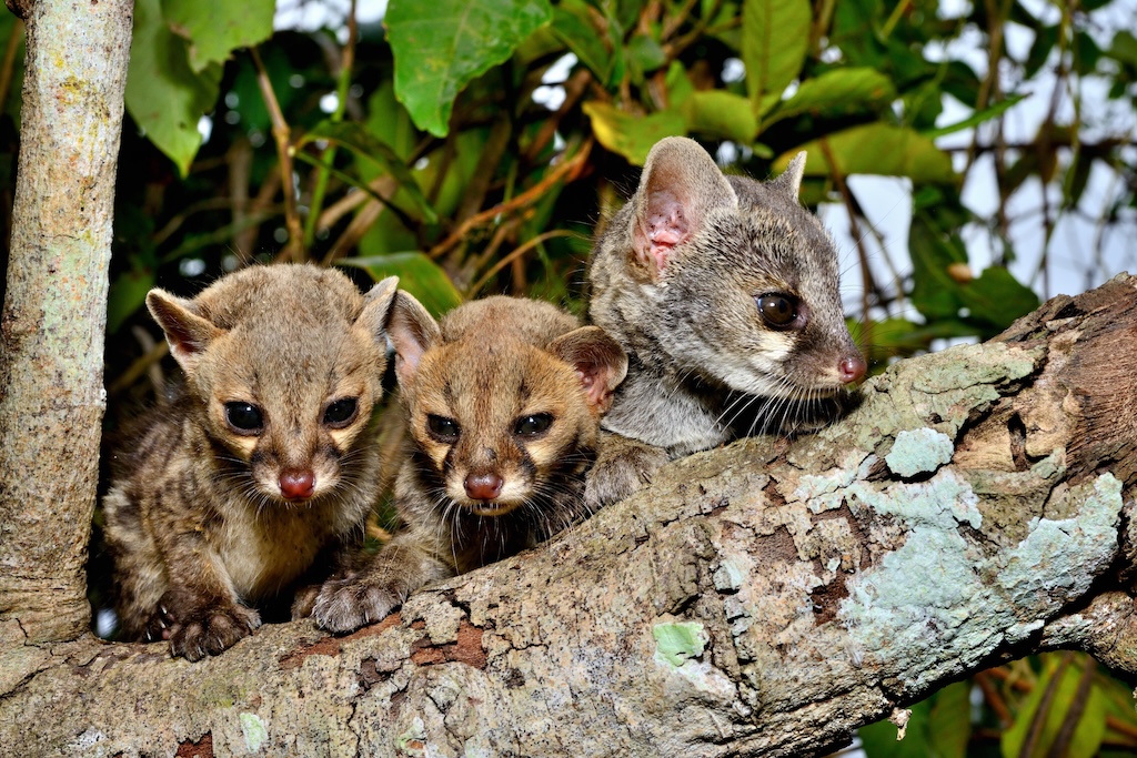
“We’re currently doing a big study on how agroforestry can help to provide habitat for birds. There also seems to be a bit of mammals that use cocoa agroforestry systems. In Ghana, we’re finding quite a bit of genets and civets that are in these systems. From Brazil, there’s a bit of research in the Atlantic Rainforest that shows that some monkeys use them as permanent habitat and others just as corridors to move through.”
Agroforestry is included in the climate commitments of around 40% of developing countries under the Paris Agreement, according to the study.
At the corporate level, the cocoa industry has made commitments to plant “millions of shade trees in agroforests to improve the sustainability of the sector”, the study says.
Blaser Hart tells Carbon Brief that the researchers hope the work will encourage the cocoa industry to better plan its agroforestry interventions, “rather than just haphazardly handing out trees here and there”.
Laurence suggests that policymakers should improve climate finance to support farmers in transitioning to sustainable agricultural systems, while chocolate producers and certification bodies should make stronger commitments to create “real demand for sustainable cocoa produced through agroforestry”.
Ultimately, the study notes that the methods it developed to assess the status of trees in agricultural systems can be used for other commodities grown in agroforests, such as coffee.


The post Growing trees for shade has ‘enormous’ potential for cutting cocoa emissions appeared first on Carbon Brief.
Growing trees for shade has ‘enormous’ potential for cutting cocoa emissions
Climate Change
Campaigners oppose Dangote’s planned Kenya refinery over climate and ecological risks
Climate and environment campaigners have urged the Kenyan government to halt plans for a proposed 700,000-barrel-per-day oil refinery backed by Africa’s richest man, Aliko Dangote, warning the project threatens one of East Africa’s most ecologically sensitive coastlines.
The refinery, which is planned to be situated in Lamu County on Kenya’s northern coast, will be East Africa’s largest refining project and is expected to take up to three years to build. Once finished, it would supply refined petroleum products to Kenya, Uganda, Tanzania and Rwanda, among others, helping to reduce the region’s dependence on imported fuels.
Campaigners are questioning the viability of such a large refinery at a time when renewable energy and electric transportation are expanding rapidly.
Mohamed Adow, director of a Kenya-based climate and energy think-tank Power Shift Africa, said the decision to give Dangote the green light for the refinery is “an extraordinary act of environmental recklessness and economic short-sightedness”, arguing it would tie Kenya to “yesterday’s energy system” just as global demand for petroleum products faces increasing uncertainty.
-
Nigeria gives fossil gas a bigger role as “transition fuel” in climate plan
Officials say the country needs time and money to ramp up renewables, but critics say betting on gas is a risky strategy that could prolong the “oil curse” -
Gas flaring soars in Niger Delta post-Shell, afflicting communities
Since the multinational sold its assets in Nigeria’s oil hub, data analysis for Climate Home News shows flaring has risen, harming locals and the climate


Campaigners argue the refinery risks coming online just as transport – the largest market for petrol and diesel – is beginning to electrify across the continent.
Kenya launched a National Electric Mobility Policy earlier this year to speed up the uptake of electric vehicles (EVs) and reduce the country’s roughly $5 billion annual fuel import bill. Ethiopia has already banned imports of non-electric vehicles and now has more than 100,000 EVs on its roads, while Rwanda is expanding its electric mobility programme with plans to convert its fleet of around 100,000 motorcycles to electric.
Adow said the project risks billions of dollars in investment in infrastructure that could become obsolete as the world moves away from oil.
“Building a refinery today assumes decades of robust demand for fuels that much of the world is actively trying to phase out,” he said in a statement.
Ecological concerns
Lamu – the proposed site for the project – is home to the UNESCO World Heritage-listed Lamu Old Town and an archipelago containing extensive mangrove forests, coral reefs and seagrass beds that support fisheries, tourism and coastal livelihoods.
Locating the refinery in Lamu would “place one of Africa’s largest fossil fuel developments in one of the continent’s most ecologically sensitive and culturally significant coastal regions,” Power Shift Africa said.
Major emitting countries knew of climate risks decades earlier than claimed
Sherelee Odayar, oil and gas campaigner at Greenpeace Africa, warned that a refinery of this scale could increase the risk of habitat destruction, marine pollution, oil spills and air pollution in one of East Africa’s most fragile coastal ecosystems.
She said the risks stem not only from the refinery itself – including storage tanks, pipelines and fuel handling facilities – but also from the large volumes of crude oil that would need to be shipped into Lamu and refined products exported by sea. Increased tanker traffic and fuel transfers, she said, would raise the likelihood of accidents in ecologically sensitive coastal waters.
Odayar added that Lamu’s low-lying, flood-prone coastline could compound those risks by damaging infrastructure and carrying contaminants from storage facilities into nearby fishing grounds and marine ecosystems.
“Lamu’s mangroves, coral reefs and seagrass beds are not expendable; they support fisheries, livelihoods and coastal protection,” Odayar added.
She said Kenyan authorities should suspend any approvals until an independent environmental and social impact assessment is completed, with genuine public participation and transparent scrutiny of the long-term economic, health and ecological risks.
“Any review must assess cumulative impacts on Lamu’s mangroves, coral reefs, seagrass beds and fishing livelihoods, alongside the wider economic risk of locking Kenya into costly fossil fuel infrastructure as the global energy transition accelerates”.
Dangote Group declined to answer questions from Climate Home News when contacted by phone.
Technological change threaten project’s future
The Kenya refinery would replicate Dangote’s 650,000-barrel-per-day refinery in Lagos, currently Africa’s largest, which has plans to more than double capacity to 1.4 million barrels per day by 2028.
Adow of Power Shift Africa said projects like this represent “a breathtaking failure to recognise where the global economy is heading”, pointing out that the East African refinery risks arriving when Africa is experiencing an unprecedented clean energy boom.
Referencing Africa’s solar boom, global electric vehicles uptake and the International Energy Agency’s projection that global oil demand is set to enter a decline later this decade, the think-tank founder said African governments risk anchoring the continent’s future to an industry facing mounting economic uncertainty.
Loss and damage fund delays first project approvals as needs dwarf resources
The organisation said the project faces a bigger threat aside from environmental opposition and that is technological change. “The danger is not simply that the refinery will pollute, it is that it will become obsolete long before it has paid for itself,” he added.
Kenyan President William Ruto said the project will create about 60,000 jobs for Kenyans and supply refined fuel to eight East and Central African countries.
GreenPeace Africa’s Odayar said the promise of ‘thousands of jobs’ cannot be used to hide the true cost of the investment which is that large fossil fuel projects often create temporary jobs while undermining existing livelihoods in fishing, tourism and small-scale local economies.
“The enormous capital required for a project of this scale could instead help accelerate Kenya’s renewable energy future through solar, wind, geothermal, storage and better energy access,” she added.
The post Campaigners oppose Dangote’s planned Kenya refinery over climate and ecological risks appeared first on Climate Home News.
Campaigners oppose Dangote’s planned Kenya refinery over climate and ecological risks
Lindsay Fenlock is a senior researcher in the Climate and Energy Program at the Center for International Environmental Law (CIEL). Nikki Reisch is a human rights lawyer and social justice advocate who leads the Climate & Energy Program at CIEL.
Much has been written about when fossil fuel companies knew their products cause harm to the climate, public health, and the environment. Less attention has been paid to just how long governments have known, too, and what they did or failed to do with that knowledge. That information is not just a matter of historical record – it’s a matter of legal responsibility.
A year ago this month, the world’s highest court affirmed that countries have been under an obligation to curb climate change since they knew about the foreseeable risks it posed and to remedy its harms. This historic advisory opinion opened the door for States to be held accountable not only for failing to act on climate change, but also for making it worse by perpetuating its primary cause: fossil fuel production and use.
While the ruling is clear about the content of climate duties under international law, it is silent on when those duties first applied to specific countries or how long they have been breaching them. The earlier governments knew about the drivers and dangers of climate change, the longer they have been under an obligation to prevent it, and the greater their potential liability for the resulting harms.
Once they were informed of the risks fossil fuels posed to the climate, States had a duty to do everything in their power to prevent those risks from materializing – and at a minimum, to refrain from exacerbating them. But, as trends in fossil fuel dependence and climate destruction make clear, they did not.
-
The loss and damage fund needs far more finance to deliver climate justice
The fledgling fund must also help vulnerable communities take action to recover from disasters by giving them direct access to grants -
A supercharged El Niño is coming – are we ready?
We need to urgently build resilience to more extreme weather and rising seas, protecting nature as an ally in adapting to climate impacts

Early knowledge
A new report from the Center for International Environmental Law shows that the governments of many major emitting countries have known since at least the 1960s that fossil fuel use was warming the planet and, if continued, could lead to dire impacts – including melting of the polar ice caps, catastrophic sea level rise, and extreme heat.
Yet some of the countries responsible for the largest cumulative shares of carbon emissions have claimed that global awareness of climate change emerged only in the late 1980s, around the time the Intergovernmental Panel on Climate Change (IPCC) was established and negotiations of a climate convention began.
Loss and damage fund delays first project approvals as needs dwarf resources
Why? Because admitting that they have known about the chief causes and foreseeable consequences of climate change for the better part of a century would mean they had a duty to prevent it that they’ve been flouting for decades.
Drawing on a wide range of publicly available government records and scientific studies, CIEL’s research exposes when knowledge of climate change made its way onto policymakers’ desks and into public discourse. The report synthesizes some of the groundbreaking research by scholars such as Naomi Oreskes on the history of American climate science, putting their findings into a legal context and broadening the discussion to other countries.
First findings in 19th century
The origins of the climate harms the world is experiencing today – more extreme storms, deadly heat waves, floods, and sea level rise – stem from around 1850, when industry began burning so much fossil fuel that the concentration of carbon dioxide in the atmosphere began to rise.
Scientists figured out quite quickly that the release of these ancient carbon stores could warm Earth. The first paper that modeled the potential warming impact of fossil fuel use, for example, came out in 1896, while the first studies that confirmed global temperatures were rising came out before World War II.
Government records show international cooperation on climate change research picking up around 1957, when countries worldwide coordinated funding for thousands of research projects as part of the International Geophysical Year (IGY).
The IGY spawned the world’s first program to monitor atmospheric carbon dioxide levels, and the 69 participating governments were apprised of the results. By this time, governmental scientific organizations in most of the world knew that continued fossil fuel use could heat the planet dramatically, with potentially significant adverse impacts. Many countries also became aware of industry research on climate change during this decade through their state-owned oil companies.
Big emitters knew
In the 1960s, the world’s top atmospheric scientists, chemists, and geophysicists concluded that fossil fuel emissions not only could warm the earth, but they were already doing so. They also concluded that continuing to release carbon dioxide into the atmosphere was likely to cause serious harm to food systems, ecosystems, human health, and communities, including through sea level rise and deadly extreme weather events. By the 1960s and 1970s, many governments had ample warning that continued reliance on fossil fuels could have profoundly dangerous global consequences.
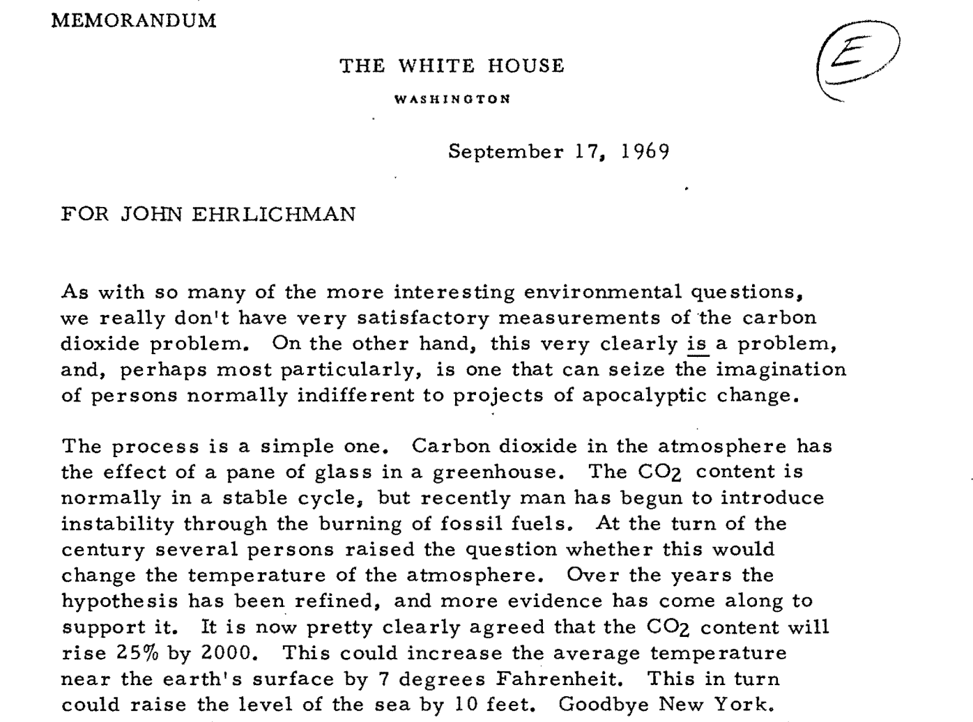
Evidence indicates that this information reached public officials — in some cases at the highest echelons of government. In the United States – the largest historic emitter of carbon dioxide – White House officials exchanged memos over what to do about the “carbon dioxide problem” during the 1960s and a presidential report published in 1965 unequivocally attributed warming to fossil fuels and warned about catastrophic levels of temperature and sea level rise if trends continued.
In the United Kingdom, the greenhouse effect was first raised in a parliamentary debate in 1969, and in France, a state-owned oil company published a magazine article about the dangers of atmospheric carbon dioxide in 1971, while the Canadian environment ministry regularly published articles about climate change in its employee magazine throughout the 1970s and 80s.
Even the most generous reading of this information shows that many of the world’s largest contributors to climate change, including the United States, Canada, Germany, and Australia, knew enough to change course over two decades before the first meeting of the IPCC in 1988, if not far earlier.
The story does not end there. As an illustrative compilation of publicly available, English-language evidence, CIEL’s report is not a complete survey of what all major emitters knew. And facts about what a given country knew are not, on their own, sufficient to secure accountability. But, together with evidence about how that knowledge was subsequently acted upon – or, as was often the case, denied, dismissed, and distorted – and about how climate impacts have unfolded, they solidify foundations for climate justice and repair.
The post Major emitting countries knew of climate risks decades earlier than claimed appeared first on Climate Home News.
Major emitting countries knew of climate risks decades earlier than claimed
Climate Change
Albanese rolls out the red carpet to data centre ‘energy vampires’, delays meaningful legislation
SYDNEY, Wednesday 15 July 2026 — Greenpeace Australia Pacific has called for an urgent pause on data centre approvals, after Anthony Albanese revealed the government’s AI legislation won’t be introduced until 2027.
The PM outlined plans for “greater clarity and speed for approvals” for data centre proponents, but, despite acknowledging the severe strain these facilities place on Australia’s land, water, and clean energy resources, will not bring legislation to Parliament until early next year.
Last month, Greenpeace called on the Federal Government to urgently implement a moratorium on the construction and approval of new data centres until appropriate regulations and safeguards are in place to protect the climate and communities.
Joe Rafalowicz, Head of Climate and Energy at Greenpeace Australia Pacific, said:
“The PM’s speech today shows that this government is kicking the can down the road, while Australians right around the country are calling for urgent regulations on AI data centres that are already being built in their backyard. We shouldn’t be talking about ‘faster decision making’ when there are no laws in place to protect our communities from this dangerous industry.
“We urgently need a moratorium on AI data centre approvals until there are binding rules in place to protect our communities, our climate and our environment. The Prime Minister is rolling out the red carpet for these water-guzzling energy vampires, with no plans to regulate them until at least 2027 — that is a betrayal of Australian communities and our national interest.
“Big tech companies are looking to make Australia their second home, but in the US, AI data centres are wreaking havoc on people’s health, drinking water and air by running their data centres on gas. They’ve set their own house on fire, and we shouldn’t be opening the door to let them do that here.
“No new data centres should be approved until there are clearly defined, enforceable regulations in place, including requiring 100% additional renewable energy, that protect people, our climate and our environment – and absolutely no new fossil fuels like gas.”
-ENDS-
Albanese rolls out the red carpet to data centre ‘energy vampires’, delays meaningful legislation


Campaigners oppose Dangote’s planned Kenya refinery over climate and ecological risks
Why Conventional Carbon Offsets Are Losing Boardroom Credibility

Major emitting countries knew of climate risks decades earlier than claimed
-
Greenhouse Gases11 months ago
Guest post: Why China is still building new coal – and when it might stop
-
Climate Change11 months ago
Guest post: Why China is still building new coal – and when it might stop
-

 Greenhouse Gases2 years ago
嘉宾来稿:满足中国增长的用电需求 光伏加储能“比新建煤电更实惠”
-

 Climate Change2 years ago
嘉宾来稿:满足中国增长的用电需求 光伏加储能“比新建煤电更实惠”
-
Climate Change2 years ago
Bill Discounting Climate Change in Florida’s Energy Policy Awaits DeSantis’ Approval
-

 Renewable Energy9 months ago
Sending Progressive Philanthropist George Soros to Prison?
-

 Carbon Footprint2 years ago
US SEC’s Climate Disclosure Rules Spur Renewed Interest in Carbon Credits
-
Greenhouse Gases1 year ago
嘉宾来稿:探究火山喷发如何影响气候预测