

Just 1% of England’s land will be needed for renewables to help meet the UK’s climate goals by 2050, according to a first-of-its-kind framework.
There is enough land in England to meet climate and nature goals, while also producing more food and building new homes, according to the UK government’s new “land-use framework”.
Speaking at the framework’s launch on Wednesday, environment secretary Emma Reynolds said she hoped it would put an end to the idea that England faces “false choices” over “solar panels versus farmland”, or “growth versus environment”.
The policy was first planned by the Conservative government in 2022, but has been delayed many times.
It has been broadly welcomed by environmental groups, with Tony Juniper, the chair of Natural England, calling it a “vital step forward” towards “more joined-up approaches” to land use.
Below, Carbon Brief outlines the main points of the framework relating to climate change, nature restoration, food production, renewable energy and housing.
- What is the land-use framework?
- What does the plan say about how land in England should be used?
- What does the framework mean for different sectors?
What is the land-use framework?
The government’s land-use framework for England aims to set out a “coherent national vision” for using land.
The 56-page report is the first of its kind in England.
It focuses solely on England, but notes that the government will “work closely” with the devolved governments in Scotland, Wales and Northern Ireland to share best practice and “collaborate on cross-border issues”.
It is a “blueprint” to inform better decisions on optimising land use to produce food, host renewable energy, restore nature and build more homes, says environment secretary Emma Reynolds in the foreword of the framework.
The plan hopes to end the “fragmented approach” to tackling these issues, which has led to a “confused picture and missed opportunities for land to deliver multiple benefits”, Reynolds says in the foreword. She adds:
“We can plant trees to reduce flood risk to homes and farmland, locate energy infrastructure alongside nature-rich food production and ensure nature recovery is at the heart of resilient growth and development.”
The report says it will play a “critical role” in helping to deliver national and global commitments, such as carbon budgets and national biodiversity and climate plans.
The framework commits to creating a long-term assessment of climate change impacts on land use at 2C and 4C of global warming.
It also commits to setting up a “land-use unit” in the Department for Environment, Food & Rural Affairs to produce a map of “national spatial priorities” in England for, among other things, food production, nature and housing.
The government says it will update the framework every five years, outlining progress and next steps on implementation.
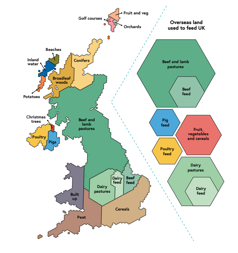
Currently, about 70% of land in the UK is used for agriculture – primarily livestock.
The chart below highlights how land is currently allocated in the UK (left) and how much overseas land is used to produce food for the UK (right).
The government’s land-use framework for England has been long-awaited and much-delayed.
The recommendation for the report first came in the 2021 National Food Strategy, an independent report led by businessman Henry Dimbleby.
It recommended creating a rural land-use framework to give “detailed assessments” of the best ways to use land in England.
The former Conservative government committed to produce such a report in a June 2022 food strategy.
This strategy said that a land-use framework for England would be released in 2023 “to ensure we meet our net-zero and biodiversity targets”, among other aims.
The publication was, however, delayed many times.
The Labour government launched a consultation on the framework in January 2025 and the final report was eventually released on 18 March 2026.
The framework is a “long-awaited opportunity for real change”, says Roger Mortlock, chief executive of the environmental charity Campaign to Protect Rural England (CPRE), in a statement.
Mortlock welcomes its “ambition”, but says that the way in which land tradeoffs are considered locally and nationally “will be key to its success”.
A report released by CPRE earlier this week, however, said that the framework is “unlikely to be the silver bullet many are hoping for”.
What does the plan say about how land in England should be used?
The framework uses high-resolution modelling – what it calls the “most sophisticated analysis” of its kind – to examine how England can use land to meet climate, nature, food and housing needs.
One key finding is that England has enough land to meet all of its objectives, if land is used efficiently.
This means that England has “enough land to deliver our objectives for nature restoration and development without reducing domestic food production or compromising on these objectives”, according to the framework.
It adds that efficient land use means “playing to the strengths” of England’s varied landscape. This involves, for example, prioritising the restoration of peatlands in north-west England and temperate rainforests in the south-west.
The chart below shows the percentage of land in England currently used for different purposes, as well as how this distribution will need to change by 2030 and 2050, if the UK is to meet its goals, according to the framework.
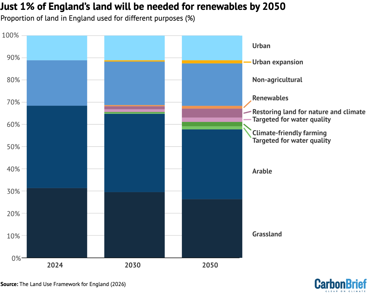
According to the framework, just 1% of England’s land will need to be taken up by renewables, such as solar and onshore wind, by 2050.
However, the framework does note that there is “inherent uncertainty” in projecting energy use by 2050 and says that the amount of land required for renewables may be nearer to “more than 2%”, depending on how quickly solar and wind is deployed in the future.
A further 6% of England’s land should be used for achieving climate and nature goals, according to the framework.
(A Defra official tells Carbon Brief that the framework’s projections for renewable energy and tree-planting were not as ambitious as those in the Climate Change Committee’s central pathway to net-zero, but are in line with the government’s carbon budget delivery plan for 2035.)
Speaking at the launch of the framework, environment secretary Emma Reynolds said that the framework shows that there are no “false choices” between “solar panels versus farmland” or “growth versus environment”, adding:
“The problem has never been scarcity of land. It has been a shortage of clarity.”
What does the framework mean for different sectors?
The framework sets out a “vision” for land use in several areas, such as housing, energy, food and nature by 2030 and 2050.
It also details what the government is currently doing to achieve these aims and makes pledges for more action down the line.
Below, Carbon Brief has detailed the key points around renewable energy, tree-planting and nature restoration, food production and housing.
Renewable energy
The report notes that the need to produce extra electricity to meet growing demand from, among other things, electric vehicles, heat pumps and data centres is “changing the way land is used across England”.
The UK plans to produce at least 95% of electricity from low-carbon sources, such as wind, solar and nuclear, by 2030.
Despite this, the report says that solar and wind will continue to make up a “small proportion of land use”. It says that, by 2030, much of this land will be “managed sustainably” for dual purposes, such as placing solar panels on the same land as growing crops.
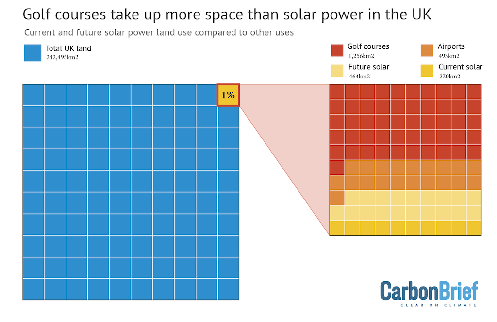
Currently, around 21,000 hectares of land in the UK is covered by solar panels – which, as Carbon Brief has previously noted, is much less than the land used for golf courses.
By 2035, an additional 129,000 hectares of land is estimated to be used for solar and wind energy in England, with some of this land also used to produce food at the same time.
If achieved, this will account for 1% of land in England and 2% of the UK’s agricultural area.
This estimate is based on the assumption that all extra solar will be installed on the ground, which the report says is a “highly conservative and unlikely scenario” given that many panels are anticipated to be placed on rooftops.
This makes the 2035 figure an “upper-bound” estimate, says the report.
By 2050, around 155,000 hectares – roughly equal to the size of Greater London – will be used for renewables, the report estimates, adding that this is based on trends from historical data and not future scenarios.
The report adds that it is possible that more land than this will be needed to meet energy goals past 2035, however, citing the “inherent uncertainty” in figuring out what the mix of electricity sources will look like by 2050.
By 2030, coordinated planning of electricity networks will encourage rural investment, “such as through new data centres”, the report claims.
By 2050, the report says that better land-use planning will lead to a “fairer and more efficient distribution of solar and wind infrastructure across England”.
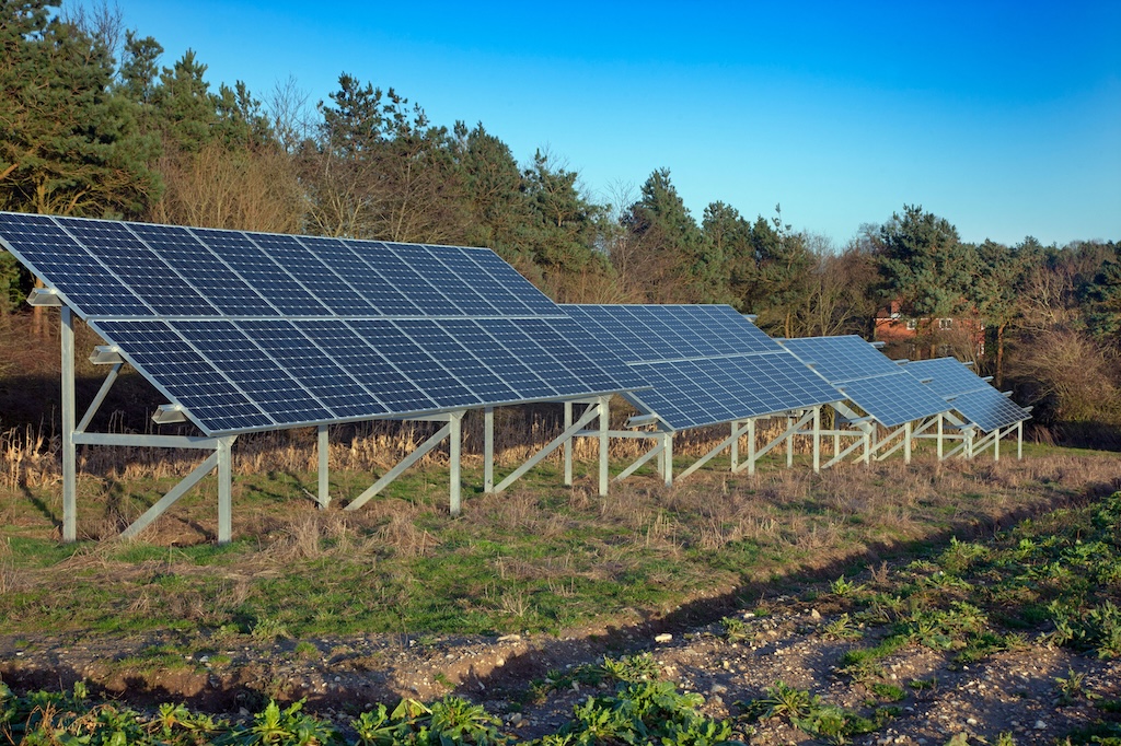
There will also be better electricity connections to renewables, much of which will be delivered alongside “productive agriculture”, such as by installing solar panels above crops – known as agrivoltaic farming.
The report says that any land-use change decisions should be made based on a number of factors, drawing from “local knowledge, values, data and priorities”.
It notes that development of wind and solar infrastructure in rural areas should give local communities the “opportunity to benefit from local clean energy”.
Tree-planting and nature restoration
According to the framework, 6% of England’s land will need to be used for achieving climate and nature goals by 2050.
This kind of land use includes restoring England’s carbon-dense peatlands, planting new woodlands and restoring heathland habitats.
As part of the analysis, the framework takes a detailed look at what parts of England would be best suited for nature restoration. It says:
“Habitat creation and restoration should be directed to the places where it can have the greatest ecological impact, help to reconnect fragmented landscapes, support priority species and deliver the greatest contribution to nature recovery.”
The chart below, taken from the framework, shows where in England has the greatest potential for nature restoration in dark green.
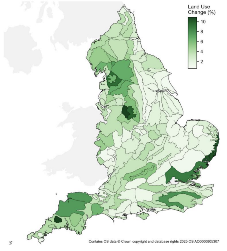
The analysis finds that north-west England has high potential for nature restoration, largely because it is home to the vast majority of the country’s carbon-rich, but degraded, peatlands.
Other areas identified include the south-west, which could be suitable for “grassland restoration and broadleaf woodland creation” and the south-east, where new grasslands could be planted, according to the framework.
The framework adds that the UK government remains committed to protecting 30% of land for nature by 2030, an international goal set under the Kunming-Montreal Global Biodiversity Framework.
However, it notes that, at present, just 7% of England’s land is protected for nature – with just four years to go until the deadline.
Speaking at the launch of the framework, nature minister Mary Creagh acknowledged that meeting the target remains a large challenge.
She added that her department was currently on a “data sprint” to try to account for all kinds of land that may not currently be classified as being protected for nature, despite serving this purpose.
Food production
The new framework extensively discusses how to balance food production with other uses for land, such as producing renewable energy and building homes.
The government says it is generally not suggesting land-use change on the country’s “best agricultural land”.
The framework focuses instead on using farmland to fulfil dual purposes, “rather than taking land out of production entirely”.
The goals outlined in the framework include increasing domestic food production in England, which the report says is “feasible according to our projections”.
Currently, the UK produces around 60% of its own food, importing the rest from abroad.
By 2030, the “vision” outlined in the framework says that farmers and other land managers will have better long-term clarity and more information on improved ways to use their land.
By 2050, meanwhile, farmlands will be managed to prioritise “sustainable food production and environmental benefits”, it says.
At this stage, the framework estimates that 480,000 hectares of farmland could be used primarily for food production, while also bringing environmental and climate benefits such as planting trees or restoring grassland habitats.
Agricultural land will be used to balance food production and other outcomes. A footnote in the report says that this will broadly lead to a “mosaic of different landscapes” – semi-natural land, low-intensity farmland and higher-intensity farmland.
It also says that, by 2050, farmland will be more resilient to climate change impacts through actions such as planting trees for flood and drought resilience.
All projected scenarios in the analysis behind the framework focus on producing food “more sustainably from less land”, the report notes.
The agricultural land-use change recommendations in the framework differ across the country. If focusing on improvements to water quality and biodiversity, for example, it recommends looking at areas with intensive agricultural production in the east of England.
This is due to these areas using high quantities of fertilisers, which can wash off fields and run into rivers and other waterways. This lowers water quality and harms plants and animals.
The government commits to developing sectoral growth plans, starting with horticulture and poultry, to provide a framework to boost production and “maintain food security”.
The government also promises to support making “under-used land” available for communities to grow food and recover nature, “where appropriate”. This refers to inactive land that is not suitable for other developments.
The report is a “step in the right direction”, says Tom Bradshaw, president of the National Farmers’ Union. He adds that it is “positive” to have “explicit recognition” of using land for multiple purposes and a government commitment to maintain food production.
Bradshaw notes that “challenges remain about delivering against the ambitious objectives as the first 2030 milestone approaches”.
Housing
Reynolds says that this framework can help to “speed up house-building and infrastructure delivery”.
The report says that, by 2030, improved planning will enable areas to facilitate housing and development “whilst protecting and enhancing the environment”.
It adds that, where appropriate, developments will be higher-density to “make the best use of land within our towns and cities”.
By 2030, biodiversity net gain – a planning requirement to improve habitats while building developments – and nature-based solutions will also be used to ensure development “leaves the natural environment in a measurably better state than it was in beforehand”, the report says.
It adds that timber production will be expanded to provide “low-carbon building materials”.
By 2050, meanwhile, the framework says planners will be able to more easily assess how suitable areas are for development “using a streamlined digital planning service and decision support tools”.
These tools – built on a range of data sources – are intended to reduce the number of homes built in areas at risk of flooding, the report says.
One in four homes in England are projected to be at risk of flooding by 2050, under a high-emissions scenario, the report outlines.
The report notes that the government is proposing a “default yes” to some planning applications for developments near well-connected transport stations.
High-demand areas “need to be powered locally and sustainably”, it notes, and using technologies such as rooftop solar to “make use of existing built land for electricity generation” can reduce land pressures elsewhere.




The post Q&A: What England’s new ‘land-use framework’ means for climate, nature and food appeared first on Carbon Brief.
Q&A: What England’s new ‘land-use framework’ means for climate, nature and food

Three countries have been named by the Paris Agreement’s compliance committee for failing to submit a nationally determined contribution (NDC) and repeatedly snubbing offers of help with their climate plans.
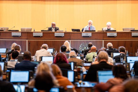
After months of internal debate over whether to identify serial non-responders, the Paris Agreement’s Implementation and Compliance Committee (PAICC) named the three countries which have failed to engage with it over their NDCs on Friday.
It named Democratic Republic of Congo, Senegal and North Korea in a footnote of its annual report, adding that it decided to name them “with a view to facilitating engagement”, adding that representatives of the three nations had been invited to its meeting in early 2027 “with the purpose of identifying any challenges and constraints”.
“The Committee noted the importance of Parties engaging with the Committee in a timely manner, while noting that some delays may be due to the national capabilities and circumstances of the Parties”, the report said.
-
Under US pressure, World Bank says it will back gas “where appropriate”
The US wants the World Bank to expand its gas support while climate campaigners are pushing for it to end – its head spoke this week of limited backing for the fossil fuel -
IPCC scientists vow to press on with climate reports despite political deadlock
After governments again failed to agree a timeline, nearly 120 IPCC authors pledged to complete their assessment on time and with full scientific rigour -
Paris Agreement committee snubbed over missing NDC climate plans
Many governments have still not submitted a nationally determined contribution to the UN, breaching a key requirement of the Paris Agreement


In July, PAICC said 12 countries had ignored its repeated attempts to discuss why they had not published an NDC as required every five years under the 2015 Paris accord.
Members of the committee had been divided over whether to name them, but at a September meeting decided to do so in their annual report to the annual climate COP summit.
By the time the report was published on Friday, only Congo, Senegal and North Korea “had not communicated an NDC or submitted a [Biennial Transparency Report] and had not yet responded to any of the Committee’s notifications, despite several reminders issued by the Committee in this regard”.
Rainforest and renewable energy ambitions
The silence from Congo and Senegal is notable because the former is home to much of the Congo Basin rainforest while the latter has sought billions of dollars in climate finance to support its renewable energy ambitions.
After Brazil, Congo has more rainforest than any country in the world. This forest, and the country’s peatlands, absorb huge amounts of greenhouse gas but are fast being lost to expanding farmland, charcoal production, logging and mining.
Senegal signed a Just Energy Transition Partnership with Canada and wealthy European nations in 2023, to help it meet its renewable energy targets under the-then government of Macky Sall. It was chair of the Least Developed Countries group between January 2022 and December 2023.

Tejas Rao, who is researching the PAICC as part of a doctoral thesis at Cambridge University, said the governments of the three countries should engage with the committee.
“Engagement costs these governments very little and the committee has shown it will listen,” he said.
“Silence leaves the committee with no basis to help, and it leaves the [governments] exposed to the narrative that they are simply disengaged,” he told Climate Home News.
Paris Agreement requirement
The 2015 Paris Agreement requires all parties to publish an NDC every five years outlining their emissions reduction targets, with each plan meant to be more ambitious than the country’s last NDC.
The latest set – the third round of plans, with new targets for 2035 – was due in February 2025. While most countries missed this deadline, all but around 30 – mostly small emitters but including Egypt, Vietnam and Argentina – have now submitted them.
Over the year, the PAICC – which is made up of government climate officials from developed and developing countries – has been communicating with governments that have not submitted NDCs and trying to overcome barriers to them doing so.
Some nations have cited exceptional circumstances as the reason for not submitting an NDC, a process that requires a significant amount of work in tracking emissions and consulting on how to curb them across the economy. For example, a letter from a Sudanese official to the PAICC, seen by Climate Home News, said that the country’s civil war had led to the suspension of its NDC preparation.