

Fossil-fuel drilling in Alaska’s Arctic National Wildlife Refuge (ANWR) could put polar bears at risk of “lethal” oil spills, new research suggests.
Former president Donald Trump passed a law to enable drilling in the refuge in 2017.
This followed decades of fierce debate between Democrats and Republicans about whether to allow extractive activities in the 7.7m-hectare (19m-acre) expanse, a haven for wildlife sitting on top of an estimated 11bn barrels of oil.
On his first day in office, US president Joe Biden suspended drilling inside the ANWR pending a review. In 2023, his administration cancelled the seven oil and gas licences issued for the reserve under Trump.
However, by law, the Biden administration is still required to hold a second lease sale for the ANWR by December 2024, unless Congress is able to pass legislation undoing the provision set out in Trump’s tax bill.
And with Trump pledging to “drill, baby, drill” if reelected to power later this year, a Republican victory in the next US election would likely see the refuge opened up for oil and gas extraction once again.
The new study, published in Biological Conservation, uses modelling to examine how a series of “worst-case scenario” oil spills could impact polar bears that use the refuge to raise young and feast on bowhead whale carcasses.
The research finds that a serious oil spill inside ANWR could expose up to 38 bears to lethal levels of oil and dozens more to harmful levels.
The risk of exposure to oil spills could be worsened by climate change, which is forcing polar bears to spend greater amounts of time on land in summer as sea ice melts away, the study lead author tells Carbon Brief.
Wild north
Republicans and Democrats have been at loggerheads about whether to drill for oil in the ANWR since the 1970s.
It is located in Alaska’s north slope, directly adjacent to a vast expanse of land that is a hotbed for oil and gas activity (see chart below). This activity includes the highly controversial Willow oil project, which was given final approval by Biden in 2023.

At present, there are currently around 2,000 oil and hazardous substance spills each year in Alaska, in areas where extractive activities already take place.
In 1989, Alaska faced one of the worst environmental disasters in US history when the Exxon Valdez oil tanker ran aground, spilling 11m gallons of oil.
Conservationists have fought to protect the ANWR, a wilderness supporting migratory caribou, wolves, all three North American bear species and hundreds of bird species. The refuge is also the home of the Indigenous Gwich’in and Iñupiat people.
But Republicans have long called for the ANWR to be opened up for drilling. According to Outside Magazine, Republicans have attempted to pass laws to enable drilling inside the ANWR nearly 50 times.
They were finally successful in 2017, when Trump passed a tax bill requiring oil and gas licensing rounds to be held for an area inside the ANWR.
However, on his first day in office in 2021, Biden issued an executive order suspending drilling in the ANWR pending an environmental review.
In 2023, interior secretary Deb Haaland cancelled the seven oil and gas licences issued in the ANWR under Trump, arguing the lease sale was “seriously flawed” for a number of reasons, including failure to “properly quantify downstream greenhouse gas emissions” from the projects.
Despite these efforts, the Biden administration is still required by law to conduct a second lease sale for the ANWR by December 2024, unless Congress is able to pass legislation undoing the provision set out in Trump’s tax bill.
Biden’s presidential campaign promised “no new drilling, period” on federal land and waters, but since entering office he has several times been compelled to hold new licensing rounds in various locations by Congress or the courts.
Dr Ryan Wilson, a wildlife biologist at the US Fish and Wildlife Service in Alaska and lead author of the new study, says his research could help to inform decisions about issuing licences within the ANWR. He tells Carbon Brief:
“There is still an opportunity to inform where development and infrastructure would be allowed for the upcoming lease sale.”
Bear behaviour
For the study, the researchers used modelling to simulate how a series of “worst-case scenario” oil spills could affect polar bears resting in the ANWR.
Polar bears are known to be “especially susceptible to oiling” from spills, the researchers say. This is because oil can damage their fur, leaving them unable to thermoregulate in their harshly cold habitat.
According to the researchers, the ANWR provides an “important habitat” for polar bears from the Southern Beaufort Sea subpopulation, a group of around 900 bears that are currently in decline.
The ANWR hosts the highest density of polar bear dens in the US.

When female polar bears are pregnant, they dig dens in the snow, where they give birth and care for their cubs for the first few months of their life. It is the “most vulnerable period in the polar bear’s life cycle”, according to Polar Bears International. Wilson tells Carbon Brief:
“We’re not sure why maternal polar bears are drawn to the ANWR coastal plain for denning, but records of denning events indicate that over the last 30-40 years there is a higher density of dens there than elsewhere on the northern coast of Alaska.”
The ANWR coastal plain also provides “important resting areas” and a “movement corridor” for bears during autumn, when sea ice is near its lowest levels, the researchers say.
At this time, polar bears feast on the remains of bowhead whale carcasses left behind by hunters from Indigenous communities.
To understand how oil spills might affect polar bears, the researchers simulated spills from three locations along the north-western coast of the ANWR coastal plain: Brownlow Point, Anderson Point and Camden Bay. (These sites are represented with hazard symbols on the map below.)

These regions have the highest oil potential – and are also areas where polar bears come ashore to feed on whale carcasses, according to the researchers.
For each spill site, the researchers simulated an underwater pipeline release of 4,800 barrels of oil every day for six days, totalling 28,000 barrels. They then tracked the path of the oil spill for 50 days.
They simulated the oil spills in autumn, when the maximum number of bears would be using the ANWR.
To estimate how many bears would be exposed, they overlaid trajectories of simulated polar bear movements with the oil spills.
They found that a spill at Brownlow Point would be the most deadly, exposing up to 38 bears to lethal levels of oil. Meanwhile, a spill at Anderson Point would expose up to 28 bears, while a spill at Camden Bay would expose up to 19 bears.
All three of the spills would also expose up to 50-60 bears to sub-lethal levels of oil each week, the researchers find.
Mounting risks
While the simulations track the movements of oil and polar bears over 50 days, they do not consider any efforts that might be made to clean up the oil and take bears to safety, the authors say.
Because of this, they describe their results as a “worst-case scenario that could help managers and oil producers prepare for the most impactful scenario they might encounter with an active oil spill”.
Wilson adds to Carbon Brief that the risk to bears from oil spills has increased because of climate change, which is causing sea ice cover in the Arctic Ocean to rapidly shrink, forcing bears to spend more time on the land surrounding the ocean, including the ANWR:
“The primary risk to polar bears in the Southern Beaufort Sea subpopulation is the loss of sea ice habitat due to climate change. The loss of sea ice is causing more polar bears to come on shore in summer and autumn for longer periods of time, which can lead to more human-polar bear conflicts, putting both bears and people at risk. This increased time on land also leads to greater risk to polar bears from an oil spill in the region.”
The study is “well-conceived and significant” says Prof Andrew Derocher, a polar bear researcher at the University of Alberta in Canada, who was not involved. He tells Carbon Brief:
“The risk to polar bears from an oil spill remains an ongoing concern and for a population like the one in the Southern Beaufort Sea subpopulation, which has already declined in abundance due to climate change, the risk of additional mortality from an oil spill is a serious concern. An oil spill in Alaska as modelled would clearly have significant negative impacts on polar bears there.”
One aspect not covered in the study is how an oil spill would likely affect polar bear prey, including ringed and bearded seals, he says:
“If there were population-level impacts on the seals, this could be an additive impact that would further slow polar bear population recovery. In addition, there is a very high likelihood that polar bears would feed on dead and dying wildlife that were oiled in a spill – specifically, seals, walrus, possibly belugas and birds. Polar bears are consummate scavengers and this secondary form of impact isn’t addressed by this paper.”
He adds the study raises the important issue of being prepared for the environmental impacts of an oil spill in the Arctic:
“I believe that no jurisdiction is prepared for a significant oil spill in the Arctic. Our ability to respond is limited by preparedness, infrastructure and staff.”


The post Alaska refuge drilling could threaten polar bears with ‘lethal’ oil spills appeared first on Carbon Brief.
Alaska refuge drilling could threaten polar bears with ‘lethal’ oil spills

Next week, diplomats from around the world will descend on Yerevan, Armenia, to negotiate a series of decisions under the UN Convention on Biological Diversity (CBD).
Between 19 and 30 October, 196 parties will gather to hammer out the precise wording of the dozens of legal texts that make up the decisions under the Conference of the Parties (COP) to the CBD.
This year’s summit is particularly significant, as it marks the halfway point between the agreement of the Kunming-Montreal Global Biodiversity Framework and the deadline for achieving its targets.
The CBD has found that countries are currently not on track to meet 22 out of the framework’s 23 targets.
During the fortnight, delegates will also be negotiating decisions relating to the two supplemental protocols to the CBD: the Cartagena Protocol, which covers biosafety; and the Nagoya Protocol, which covers access and benefit-sharing for the use of genetic resources.
(The Cartagena and Nagoya Protocols, which are each governed by a “meeting of the parties”, or “MOP”, have fewer parties than the CBD as a whole, with 173 and 141, respectively.)
Carbon Brief is tracking the progress of countries towards consensus on dozens of negotiating texts using the interactive table below.
The tracker includes texts from the COP, as well as the MOPs for the Cartagena and Nagoya protocols. It also includes draft decisions from the most recent subsidiary body meetings, as these form the starting point for the negotiations in Yerevan.
The CBD has three subsidiary bodies: the subsidiary body on scientific, technical and technological advice (SBSTTA), the subsidiary body on implementation (SBI) and the subsidiary body on article 8(j) and other provisions (SB8J).
SB8J focuses on issues related to the Indigenous peoples and local communities. It was established at COP16 in Cali, Colombia, in 2024.
The first two columns of the interactive tracker list the topic of each agenda item and the relevant body, with subsequent columns including dates, page counts and links to the original documents.
The table is searchable and can be sorted using the arrows in the header.
Areas of disagreement in UN draft texts are denoted by square brackets. Counting the brackets in a particular iteration of a text therefore gives a sense of how far parties are from reaching consensus.
The bracket column is colour-coded, with dark green indicating a low number of brackets and red indicating a high number of brackets remaining.
Texts can also present parties with choices using “options” or alternatives (“alt”), which are counted together in the sixth column of the table.
The key discussions in Yerevan will centre around two agenda items in particular. The first is the global review, which will assess progress towards the GBF and make recommendations for accelerating action.
The second is finance, which can be separated into two parts: resource mobilisation and the financial mechanism. On resource mobilisation, biodiverse global south countries are likely to push for an increased amount of international finance for conservation.
Disagreement over the creation of the financial mechanism led to the suspension of COP16 in Cali in October 2024, as parties failed to find agreement on the mobilisation of finance before the end of the summit.
Global south countries want the establishment of a separate financial mechanism under the control of the CBD; global north countries largely prefer to maintain the existing mechanism, which sits under the Global Environment Facility.
At the resumed session of COP16 in Rome in early 2025, countries agreed on a roadmap that would lead to the establishment of a permanent mechanism.
related

Analysis: Lula presidency saved at least 20,000km2 of Brazilian Amazon since 2022
Why land-use emissions have fallen by a third this century – in six charts

Analysis: 84% of nations miss deadline to identify ‘nature-harming’ subsidies by 2025
UK withdraws millions in funding from world’s second-largest rainforest in Congo
The post Interactive: Tracking negotiating texts at the COP17 biodiversity summit appeared first on Carbon Brief.
Interactive: Tracking negotiating texts at the COP17 biodiversity summit
A beacon of love
On an outer island of Fiji, two thousand nautical miles from Sydney, is a shining light of hope and resilience for our troubled world.
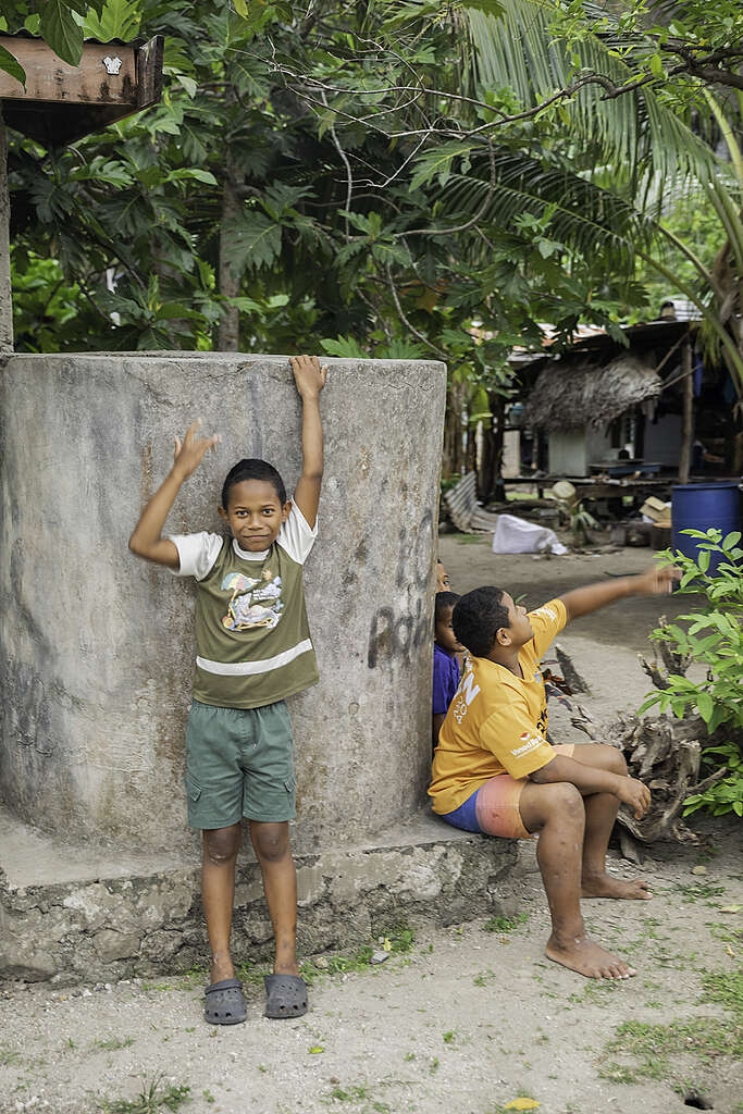
The island of Kioa is home to a Tuvaluan community who migrated from their atoll of Vaitupu in the late 1940s. It is a land of warm hearts, big smiles, and deep cultural roots; a place where the sound of a conch still summons the island together, where islanders paddle out to fish in carved outrigger canoes, and healthy happy children walk barefoot to school.
Here, culture is life. Kioans live sustainably through their traditional knowledge and practices. The island is alive with song, dance and the rhythms of a life tied to the tides, the winds, and the seasons.
Facing the future
Greenpeace has been lucky to have a relationship with Kioa for a number of years now, and we are continually learning from this remarkable community.
Last week, as part of our Voyaging Oceania project, we returned to the island. Our purpose was twofold —- to carry messages from the island to leaders gathering in Nadi this week for the Pacific Pre-COP, and to support the Kioa community in their efforts to improve water security for the island.
Unlike Tuvalu itself, with its eight atolls, Kioa is a mountainous, forested and richly fertile island. It will remain habitable far into the future. Kioans did not initially migrate from Vaitupu due to climate change, but the move was prophetic. They now have a lifeboat.
However, even Kioa faces challenges on our rapidly warming planet, in particular when it comes to water. Climate change is shifting once reliable rainfall patterns. On top of this, the island is already feeling the effect of this year’s intensifying El Niño event, which for Fiji means reduced rainfall and prolonged dry spells.
Right now, fresh water has to be carefully rationed, and is only available for a few hours a day. During last week’s visit aboard our campaigning ship Oceania, Greenpeace was privileged to work with the Kioa community on a new solar-powered water distribution project for the island.
Designed and led by the island, the project involves using a solar pump to move water from a reliable source to a storage tank and then using gravity to distribute the water around the village.
It was a lesson in how local knowledge and ingenuity can be the backbone of today’s climate solutions. To build a dam around the source, the local community knew the exact spot where they could gather gravel at low tide to mix with the cement. They took only what was needed, knowing that all resources must be carefully conserved. Kioa has no roads and no machinery, and it was an all-of-island effort to carry the materials up to the project site, including many heavy bags of sand and rock.
Such projects truly bring to life the vision of a resilient, locally-led, fossil fuel free Pacific.