Connect with us

Published

on

Over the past decade, research has emerged suggesting that ramping up reforestation around the world could make a substantial contribution to tackling climate change.

Studies have estimated that the CO2-absorbing power of newly planted trees could add up to mitigation “potential” of 10bn tonnes (GtCO2) per year – more than the annual emissions of the US.

Achieving this would require planting trees across 678m hectares – an area twice the size of India.

But the uncertainty around those figures is large due to a range of factors, such as where sufficient trees already exist, how much climate mitigation those trees offer and where people actually want additional trees to be planted.

In our new study, published in Nature Communications, we unpack eight years of research into reducing these uncertainties.

We have quantified, for example, how the carbon-sucking power of trees changes when you let forests grow back naturally versus planting monoculture or mixed-species plantations.

We figured out how much carbon could be removed at different price points and mapped where trees – somewhat counterintuitively – actually act to warm, rather than cool, our climate.

But, as we shrank the uncertainty, we also shrank the estimate itself.

Our research provides the most precise estimate of global reforestation area to date – 195m hectares, or 71% less than earlier estimates.

Reforesting an area this size could capture 2GtCO2 per year.

Mapping reforestation opportunity

Maps of global reforestation potential have been cited in thousands of scientific publications, inspired large-scale tree-planting movements and been used by the International Panel on Climate Change (IPCC) in its flagship reports.

However, they have also been very controversial.

Critics have pointed out, for example, that these maps failed to account for natural disturbances that prevent forest growth, ignored existing trees and overlooked the people that live, steward and often depend on those lands for their wellbeing.

In our new study, we resolved to produce a map that addresses these past critiques.

We began by searching for existing maps of reforestation “opportunity”.

Our search uncovered 89 such maps, although most of those we identified are national or sub-national. Some places – such as Brazil’s Atlantic Forest – have many maps, but we found that most of the globe was only covered by a single older, more controversial map.

The map below shows where we found existing maps at the global, regional, national and sub-national levels.
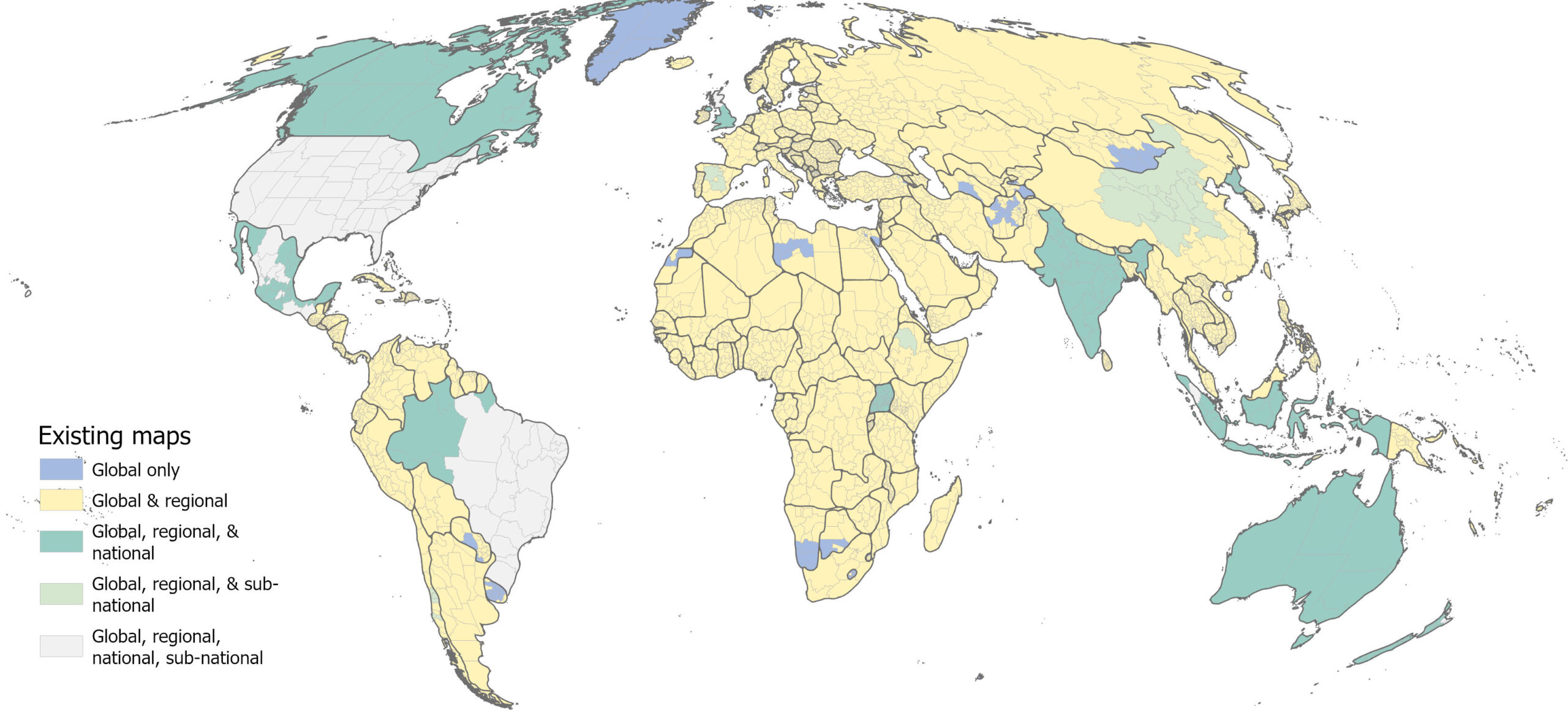
Coverage of peer-reviewed reforestation maps published 2011-2022 (n=89) by Global Administrative Areas v 4.1 level 1 unit
Existing coverage of peer-reviewed maps of reforestation potential, all published between 2011 and 2022. The colours indicate the coverage of the map: global only (blue), global and regional (yellow), global, regional and national (teal), global, regional and sub-national (light green) and global, regional, national and sub-national (grey). Source: Fesenmyer et al. (2025)

Thus, we set about creating a new global map that built upon the methods of past efforts, tackled prominent critiques and incorporated newly available layers.

Our new map accounts for albedo, for example – how restoring tree cover can, in some locations, actively heat the Earth, rather than cool it, by affecting how much sunlight is absorbed or reflected.

It excludes native grasslands and other ecosystems where carpeting the land with trees would harm biodiversity and exacerbate the risk of wildfire. And it layers in additional safeguards, such as food security, to ensure that reforestation outcomes are more likely to be beneficial to people.

These constraints left us with up to 195m hectares of reforestation opportunity across the world.

A reforestation ‘menu’

Not all reforestation opportunities are created equal – different communities may want to implement reforestation for different reasons, such as restoring floodplains or re-establishing iconic ecosystems that have been lost.

So, alongside the reforestation opportunity, our map shows other factors that communities or decisionmakers may use to help them prioritise areas for reforestation.

We show, for example, where natural regeneration may be most likely to occur and where biodiversity benefits may be greatest, given proximity to existing forest. We show where reforestation opportunity exists on slopes and floodplains – and therefore is more likely to provide benefits for the local watershed. We show places where people have strong rights and secure land tenure, to avoid exacerbating social inequities.

Perhaps unsurprisingly, it is hard to find places that tick all of these complex boxes. But, it is still possible to achieve multiple objectives in one location.

In fact, our study finds that 83% of reforestation opportunities occur close to existing forest, while 81% occur in places that are expected to have low conflicts with rural livelihoods.

More than half of the opportunity that we identify also occurs in countries with explicit restoration goals – places such as Brazil’s Atlantic Forest, where we are working with local partners and communities to restore 1.2m hectares of forest. Forest restoration there contributes to national climate goals, supports sustainable economic development and connects habitat for wildlife.

Alongside the paper, we present the Global Reforestation Hub, which allows users to explore this menu of reforestation options, drill down to reforestation potential at county level and see what opportunities meet a given set of objectives.

For example, a government interested in climate mitigation and protection from floods might use the tool to find the places within their country where both goals might be achieved via reforestation.

The screenshot below shows the Global Reforestation Hub. Countries are coloured by their total reforestation opportunity, from low (white) to high (dark blue). The table shows the amount of land available for – and the CO2 mitigation potential of – reforestation given different priorities and constraints.
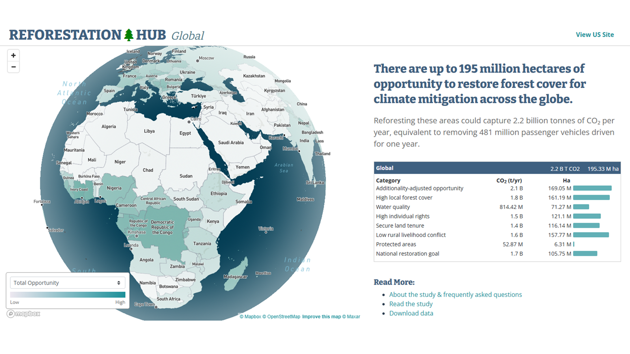
The Global Reforestation Hub homepage
The Global Reforestation Hub homepage.

Smaller can be better

Reforestation remains one of the most cost-effective climate removal options, but it cannot – and should not – happen everywhere.

While there are certainly opportunities to plant and regrow trees beyond what we have mapped here, we created these maps to show where the climate mitigation opportunities – and their co-benefits – are most concentrated.

Prioritising other motivations, such as human health, habitat for specific wildlife species or local considerations, would also increase the total reforestation opportunity area. For example, our maps don’t include the potential for reforestation in dense urban areas, but trees in those areas can be highly beneficial for human health.

Our study prioritised mapping opportunities for climate change mitigation – and we were deliberately conservative, erring on the side of caution when determining which places to include.

The result is a map that shows the places where reforestation offers both the greatest climate benefits and the fewest downsides for both people and nature.

During a year when the UN climate COP will be hosted in the most iconic forest of all, our study is less a critique of the pre-existing numbers and more an effort to create the most precise and pragmatic maps of reforestation potential. This can help ensure that we get the reforestation part of the climate equation right.
The post Guest post: Why the global area for regrowing trees is 71% smaller than thought appeared first on Carbon Brief.

Guest post: Why the global area for regrowing trees is 71% smaller than thought

Continue Reading

Climate Change

South Africa’s offshore oil push meets grassroots resistance in court

Published

on

Layers of red dust coat South Africa’s Saldanha Bay, a legacy of the one billion-plus tonnes of iron ore exported from what was once a quiet coastal fishing town in the 1970s. Now the government wants to turn this area into the “oil and gas hub of South Africa”, but opposition from local communities and civil society could force a change of plan.

Since 2014 South Africa has developed a strategy for taking “full advantage” of its marine resources, known as Operation Phakisa. It has resulted in the mapping of more than 95% of the country’s nearly 3,000-kilometre coastline for offshore oil and gas exploration.

The plan seeks to “drill 30 exploration wells in 10 years”, which it estimates could lead to the production of an average of 370,000 barrels of oil and gas per day over 20 years, with Saldanha Bay earmarked as a key logistics hub. It also aims to develop other marine sectors like aquaculture, maritime transport and ocean tourism.

However, two major court cases against the government and oil giants Shell and TotalEnergies have challenged those plans, as coastal residents, allied with national civil society groups, have pushed back against oil concessions held by the multinationals, arguing they were not consulted, and that towns like Saldanha Bay could face social and environmental harms from the fossil fuel extraction.

    Melissa Groenink-Groves, programme manager at legal nonprofit Natural Justice, said the cases in South Africa could set a precedent for the whole region. “When communities win in the courts, the successes serve as inspiration for other communities to advocate [for] their rights in their own contexts,” she explained.

    She added that the legal challenges to Operation Phakisa also develop climate litigation in the African context, and could impact how environmental impact assessments are conducted going forward.

    Globally, as the oil and gas industry sets its sights on the ocean, with over 85% of new discoveries in 2024 made offshore, scientists and activists warn it could threaten marine life and coastal communities, and weaken the ocean’s ability to trap excess heat from the atmosphere, fuelling planetary warming further.

    A demonstration against TotalEnergies' offshore oil exploration effort in South Africa.
    A demonstration against TotalEnergies’ offshore oil exploration effort in South Africa. (Photo: Ashraf Hendricks/GroundUp News)

    Taking oil companies to court

    About 300 kilometres north of Saldanha Bay, the Aukotowa Fisheries Cooperative, backed by nonprofits The Green Connection and Natural Justice, has taken TotalEnergies to court over its plans to drill for oil and gas in a 30,000-square-kilometre block off South Africa’s west coast.

    The oil exploration block is in a biodiverse marine area bordering Namibia and South Africa known as the Orange Basin, which is a “highly relevant” sanctuary for endangered species, according to Nelson Mandela University’s Institute for Coastal and Marine Research.

    Among other grievances, the cooperative maintains that the company’s environmental impact assessment was flawed, failing to consider the project’s contribution to climate change, and that the government “placed the profits of a multinational corporation above the livelihoods of vulnerable coastal communities”. The Western Cape High Court concluded hearings in late March and is expected to deliver a ruling later this year.

    Walter Steenkamp, chairperson of the Aukotowa Cooperative, is concerned that the oil and gas drilling will lead to increased inequality, asking “for whom is the development? Definitely not for us.”

    In a written statement, TotalEnergies told Climate Home News that it “is a responsible operator fully committed to complying with all applicable South African legislation”.

    Southeast Asia’s fragile grids threaten billions in clean energy investment

    Communities and climate impacts at stake

    On the other side of the country, along South Africa’s eastern coastline, community-based nonprofit Sustaining the Wild Coast and partner organisations challenged Shell and Impact Africa’s exploration permit, arguing that the firms had failed to consult impacted communities – a legal requirement under South African law.

    Co-plaintiff Sinegugu Zukulu also said in 2022 that “oil and gas will lead to more emissions, and in the face of climate change, this is wholly irresponsible”.

    Following two rulings against the companies by lower courts, the case is now before South Africa’s highest Constitutional Court, which has reserved judgment since September 2025. A ruling against the companies would be final, effectively ending the exploration permit.

    Legal expert Groenink-Groves said oil exploration applications under Operation Phakisa have been “granted largely without properly assessing the devastating impact an oil spill could have on small-scale fishers, the risks of drilling in ultra-deep waters, [and] without accounting for climate change impacts associated with oil and gas exploitation”.

    She added that exploration applications have often failed to consider coastal management laws and in some cases, cross-border and regional environmental risks.

    Shell and South Africa’s Department of Mineral and Petroleum Resources did not respond to written requests for comment.

    Co-plaintiff in the case against Shell Sinegugu Zukulu.
    Sinegugu Zukulu, co-plaintiff in the case against Shell. (Photo: Tom van der Schijff)

    South Africa’s offshore oil ambitions

    Fishers around South Africa, many of whom have for generations relied on marine resources for survival, say the country’s offshore oil and gas push is sacrificing their livelihoods for profit.

    “Why do they want to destroy our heritage? We can’t afford to say yes to oil and gas because the ocean is our source of life,” said Carmelita Mostert, a member of advocacy group Coastal Links and third-generation Saldanha Bay fisher.

    Yet with unemployment above 30%, alongside high levels of poverty and wealth inequality, the government sees Operation Phakisa as a vehicle for socioeconomic development.

    South Africa’s Minister of Mineral and Petroleum Resources Gwede Mantashe has described the court cases as “anti-development”, and claimed that the environmental organisations are funded by the CIA.

    Sifiso Dladla, a campaigner with human rights organisation groundWork, argued that the close relationship between the government and the fossil fuel industry – including its 3% contribution to gross tax revenue – limits the potential success of movements pushing for an inclusive energy system. Politicians “need money to win elections. Mining companies need the government to protect them,” he said.

    Patrick Bond, a political economist and sociology professor at the University of Johannesburg, said Operation Phakisa only makes economic sense if its social and environmental harms are ignored, adding that “if a genuine social cost of carbon analysis were done in any African fossil fuel project, there would be few – if any – able to justify the projects economically”. 

    At a global scale, Bond said oil multinationals have the financial backing of European governments – including France’s $2.8 billion stake in TotalEnergies – which can help make local resistance more effective where it has international allies to amplify the messages.

    For Saldanha Bay fisher Mostert, the fight is about protecting the livelihoods of coastal communities. “It is my hope that we can stand strong and protest,” she said. “If oil and gas is not allowed, our lives will be much easier and better – but if oil and gas goes ahead we will be in absolute agony.”

    The post South Africa’s offshore oil push meets grassroots resistance in court appeared first on Climate Home News.

    South Africa’s offshore oil push meets grassroots resistance in court

    Continue Reading

    Climate Change

    Millions of kilograms of marine life taken from Australia’s marine protected areas every year, FOI finds

    Published

    on

    SYDNEY, Tuesday 11 August 2026 — New data obtained by Greenpeace Australia Pacific has found millions of kilograms of marine life are being taken from Australian marine parks by commercial fishers annually, as the government begins its review of the country’s Marine Parks Network.

    The data, released to Greenpeace in response to a Freedom of Information request, relates to 18 of Australia’s 60 Commonwealth marine parks, and shows almost 2.2 million kg of marine life is being fished each year, raising concerns about the true catch numbers across all marine protected areas.

    Greenpeace is calling for the Labor government to use the once-in-a-decade Marine Parks Network review, announced last fortnight, to ban industrial activities, including bottom trawling, longlining and oil and gas mining, from Australia’s Marine Parks Network, and increase fully-protected ocean sanctuaries within the network.

    Elle Lawless, Senior Campaigner at Greenpeace Australia Pacific, said:

    “It’s chilling to think of the true scale of destruction happening inside all of Australia’s marine parks, and how much of our precious ocean wildlife, like dolphins, turtles or seabirds, could be pulled out of protected areas as bycatch.

    “We’re talking about 6,600 kilograms of wildlife in one day, and that does not include what’s caught in the other 42 marine parks, many of which allow destructive fishing like longlining.

    “Australia has made significant progress in securing 52% of its oceans in marine parks; however, this intent is undermined by zones that allow damaging industrial fishing activities, such as bottom trawling and longlining. The review of Australia’s Marine Parks Network is a critical opportunity to fix what isn’t working and finally give our oceans the real protection they deserve.

    You wouldn’t expect someone to bulldoze a national park on land, so why should they be allowed to trawl in a marine park?”

    “Greenpeace Australia Pacific welcomes the Albanese Government’s review of the Commonwealth Marine Parks Network as a rare opportunity to strengthen our marine parks and ban industrial fishing in Australia’s marine protected areas.”

    The documents reveal that the south-west network has the largest catch volume, at 887,160kg per year, followed by the Coral Sea network, which extends out from the Great Barrier Reef, losing significant wildlife at 808,840kg annually.

    —ENDS—

    Notes:

    • More than half of Australia’s Marine Parks Network allow extractive industries, including industrial fishing and oil and gas mining.
    • The data, supplied by the Department of Agriculture, Fisheries and Forestry, does not specify how much of the catch is fish or bycatch, like non-target fish, turtles or seabirds, and is available on request.

    Millions of kilograms of marine life taken from Australia’s marine protected areas every year, FOI finds

    Continue Reading

    Climate Change

    Marine Parks Explained

    Published

    on

    Australia’s network of marine parks is the largest in the world, covering more than half (52%) of Australia’s Commonwealth waters. You could be forgiven for assuming that a marine park is much like a national park on land: a highly protected place where people can enjoy nature while conservation efforts help habitats recover and wildlife thrive. You wouldn’t expect someone to bulldoze a national park, so why should they be allowed to bottom trawl in a marine park?

    The reality is that not all marine parks are equally protected. Australia’s Marine Parks Network is divided into different zoning categories, with each zone determining which activities are permitted and the level of protection provided.

    More than half of the Commonwealth Marine Parks Network allows industrial activities like oil and gas mining, and industrial fishing.

    Our survival, and the survival of our planet, depends on the ocean. The ocean produces more oxygen than all of our forests combined, sustains communities and regulates the earth’s temperature. It’s home to wondrous wildlife and important ecosystems like coral reefs and kelp forests.

    We love our big blue backyard

    Australia’s ocean is teeming with life that is found nowhere else on earth. Schools of colourful fish, vibrant coral reefs, endemic shark nurseries, pods of dolphins, families of whales, playful seal pups and threatened Jurassic-era turtles call Australian waters home.

    Since time began, from the turquoise waves to the deep blue, the ocean has connected our shorelines and communities, fed us, guided us and grounded us. We are intrinsically connected to our big blue backyard – more than 85% of us live within 50km of the shoreline. For tens of thousands of years, people have lived in harmony with the ocean and the wildlife within it, caring for and being sustained by its rich waters. Australia’s waters are some of the most unique and abundant places on Earth but our Marine Parks Network is falling short to properly protect them. 

    Australia’s marine parks aren’t living up to their name

    © Greenpeace / Harriet Spark

    The Australian Commonwealth Marine Parks Network covers commonwealth waters 5.5km from the coast. The network is divided into 7 regional management areas, overall the network contains 60 marine parks. Zoning types determine what activities are allowed in each area. Over half of the network allows industrial activities, risking our most precious and threatened ocean wildlife.

    Within many of our marine parks, destructive industries are allowed to fish, trawl, dig and mine using barbaric and cruel methods. Here are some of the zones explained:

    • Bottom Trawling: Special Purpose (trawl) zones allow bottom trawling. This covers 10 marine parks totalling almost 13 million hectares. Bottom trawlers bulldoze the seafloor with weighted nets, deforesting our underwater forests; a cruel, indiscriminate and inefficient way to fish.
    • Other Industrial Fishing: Includes “Habitat Protection Zones, ““Multi Use Zones” and “Special Purpose Zones.” Fishing methods vary from park to park but many marine parks in these zones allow industrial fishing like longlining. Longlining involves setting lines that can be 100km long, bristling with deadly hooks designed to catch a specific fish species. But longlining is not a selective method of fishing – significant numbers of sharks, rays, turtles, dolphins and seabirds can be harmed or killed as bycatch in the process.
    • Oil and Gas Mining: Many “Special Purpose” and “Multi Use” zones allow seismic blasting and oil and gas mining. 30 marine parks or 65 million hectares of Australia’s highest conservation value areas for ocean wildlife are open for mining and exploration of oil and gas.
    • Ocean Sanctuaries: National Park and Sanctuary zones are fully and highly protected marine parks designed to conserve wildlife and their habitat, where fishing, mining, and other industrial activities are not allowed.

    Industrial fishing is one of the biggest threats to the ocean

    Marine parks on the east coast that allow bottom trawling. 10 marine parks across the whole network allow bottom trawling totalling almost 13 million hectares of ocean habitat for precious wildlife.

    In May, Greenpeace Australia Pacific sailed our campaigning vessel Oceania through some of Australia’s most beautiful and threatened marine parks. Our crew visited Jervis and Hunter marine parks to document their beauty, showcase what’s at risk and aim to expose the industrial fishing activities in these protected waters. Both of these marine parks allow bottom trawling and longlining methods of industrial fishing.

    Industrial fishing is ripping the ocean apart across the planet. Longlining, also known as longline fishing, is an industrial fishing method that involves the use of a fishing line with thousands of baited hooks. These fishing lines can stretch over 100 kilometers in length and are set to capture a fish species, often tuna or billfish species. But it is not a selective method of fishing  and often results in significant bycatch. This includes a range of non-target species like sharks, rays, sea turtles, marine mammals, and seabirds which are often injured or killed as bycatch.

    Bottom trawling involves dragging heavy weighted nets along the ocean floor. This fishing method is popular with commercial fishing companies, because it makes it easy to catch large quantities of fish in one go. But it also damages the seafloor, releasing carbon and can kill or injure non-target ocean life like coral, fur seals, dolphins and seabirds. You may have watched the reality of bottom trawling (and the benefits of ocean sanctuaries) in Ocean with David Attenborough, if not, add it to your watch list!  

    Fully protected ocean sanctuaries that ban industrial fishing and mining can protect ocean wildlife and underwater wonderlands for generations to come. Vast, robust sanctuaries create blue havens where ocean wildlife are safe from nets and hooks, and can truly rest, recover, thrive and replenish out into the surrounding waters. Ocean sanctuaries ensure a healthy ocean full of life.

    A once-in-a-decade chance to fix what’s falling short

    We have a unique opportunity to turn the tide.

    The Australian Government is asking for your feedback on how our Commonwealth Marine Parks Network is managed. This is our once-in-a-decade chance to protect ocean wildlife, ban industrial fishing and create more ocean sanctuaries.

    As part of the review the Government is asking for submissions from the public to hear from you on what improvements are needed to better protect our vast network of marine parks. Writing a submission is a powerful way to influence government decisions and create real change.

    This is the moment to ban industrial activities like bottom trawling and oil and gas mining. But only if they hear from YOU. Add your name!

    Greenpeace is calling on the Australian government to:

    1. Ban industrial activities from Australia’s Marine Parks Network: Ban industrial activities, such as industrial fishing, seismic blasting and oil and gas mining, from Australia’s marine parks.

    2. Create more ocean sanctuaries: Increase fully protected sanctuaries in Australia’s marine parks based on science principles.

    3. Connect Australia’s Marine Parks Network to the High Seas: mCreate seascape connectivity by linking Australian marine parks to new high seas ocean sanctuaries.

    References

    Substantiation that more than half of the Marine Parks Network permits industrial activity comes from a peer-reviewed systematic literature review (Phillips et al. 2025, PLOS One, https://doi.org/10.1371/journal.pone.0307324). The study found that within the Commonwealth Marine Parks Network specifically, “all zones are considered partially protected areas, meaning areas where extractive activities are permitted, except ‘Pink zones’ (Preservation Zones; IUCN Ia) and ‘Green Zones’ (IUCN II).” In other words, every Commonwealth marine park zone type other than the network’s strict no-take sanctuary and national park zones (IUCN Ia and II) permits some form of extractive industrial activity. Since no-take zones are the minority zone type across the network by area, this supports the conclusion that the majority of the network’s area is zoned to permit industrial activity.

    DCCEEW Australian Marine Parks spatial dataset (https://fed.dcceew.gov.au/datasets/erin::australian-marine-parks/explore), filtered by zone type. This confirms that 38.43% of the network’s area is zoned as Sanctuary or National Park zones (IUCN Ia and II). These are the no-take categories excluded from the peer-reviewed study’s definition of partially protected/industrial-permitting zones. The remaining 61.57% of the network falls within the zone categories the study classifies as permitting industrial activity (per The MPA Guide definition of “industrial” applied in Phillips et al. 2025), directly corroborating the peer-reviewed finding with current Commonwealth-specific spatial data.

    For further information on activities permitted within the Marine Parks Network Zoning, you can refer to the Management Plans zoning and rules for each Marine Parks Network area, for example: Temperate East, Coral Sea, North.

    Marine Parks Explained

    Continue Reading

    Trending

    Copyright © 2022 BreakingClimateChange.com