

The Greenland ice sheet melt season for this year is over, resulting in the 28th year in a row in which Greenland has lost ice.
This has been a spiky year for Greenland – a mix of highs from abundant snow in winter and lows from some very high melt days in summer.
Those spikes of high snowfall delayed the onset of the melt season in June and reduced melt substantially in August. Fresh snow is a brighter white than old glacier ice, so summer snow effectively acted as a shiny protective blanket – just when the high melt season was getting going.
The 2023-24 year, as the year before, had strong melt rates throughout the northern-hemisphere summer, but also above average snowfall during winter and in June. As a result, the balance between accumulated snow and melting ice on Greenland’s surface ended above the 1981-2010 average.
The increase in both melt and snowfall are exactly what scientists expect in a warming climate. But, overall, Greenland has again lost more ice than it gained – even though, as in previous years, Greenland was comparably cool compared to North America and Europe.
High “calving” rates – the breaking off of icebergs at the face of the ice sheet – meant that Greenland lost 80bn tonnes of ice over the 12 months from September 2023 to August 2024. The last year to see a net gain of ice is still 1996.
This marks the 10th year of these annual reviews – see our previous annual analysis for 2023, 2022, 2021, 2020, 2019, 2018, 2017, 2016 and 2015.
Surface melt
Greenland’s annual cycle covers the 12 months from the previous September up to the end of August. Over this period, we calculate the “surface mass budget” (SMB) for the ice sheet.
The SMB is akin to the bank account for the surface of the Greenland ice sheet. It is the balance between gains (from snowfall) and losses (from ice melt and runoff).
As the ice sheet largely gains snow from September, accumulating ice through autumn, winter and into spring, we start the ice budget year on 1 September.
Then, as the year warms up into late spring, the ice sheet begins to lose more ice through surface melt than it gains from fresh snowfall, generally from the mid of June.
This melt season usually continues until the middle or end of August, the end of the surface budget year.
Snowfall is the only way for the ice sheet to gain mass. Therefore, for the size of the ice sheet to remain constant, this snow must outweigh all other ways the ice sheet can lose ice – iceberg calving, melt at the base of the ice sheet and evaporation from the surface.
According to our calculations, the Greenland ice sheet ended the year 2023-24 with an overall SMB of about 367bn tonnes (Gt). This is the 19th highest SMB in a dataset that goes back 44 years, and it is close to the 1981-2010 average of 348 Gt.
The past year’s SMB is illustrated in the maps and charts below, based on data from the Polar Portal. The blue line in the upper chart shows the day-to-day SMB. Large snowfall events become visible as “spikes”. The blue line in the lower chart depicts the accumulated SMB, counted from the beginning of the “mass balance year” on 1 September 2023. In grey, the long-term average and its variability are shown. For comparison, the red line shows the record-low year of 2011-12.
The map shows the geographic spread of SMB gains (blue) and losses (red) for 2023-24, compared to the long-term average. This shows that southern Greenland had a relatively wet year compared to the long-term average, but the north-west and west lost more than usual. The spikes of snow and melt are clear in the graphs on the right.

Heat over Europe and North America, cool over Greenland
While southern Europe sweltered through multiple heatwaves, northern Europe (with the exception of Arctic Scandinavia) had a rather cool and rainy July, followed by a warmer and sunnier late summer. Svalbard also suffered record temperatures and record amounts of glacier loss this year.
And, yet, Greenland was spared these bouts of heat.
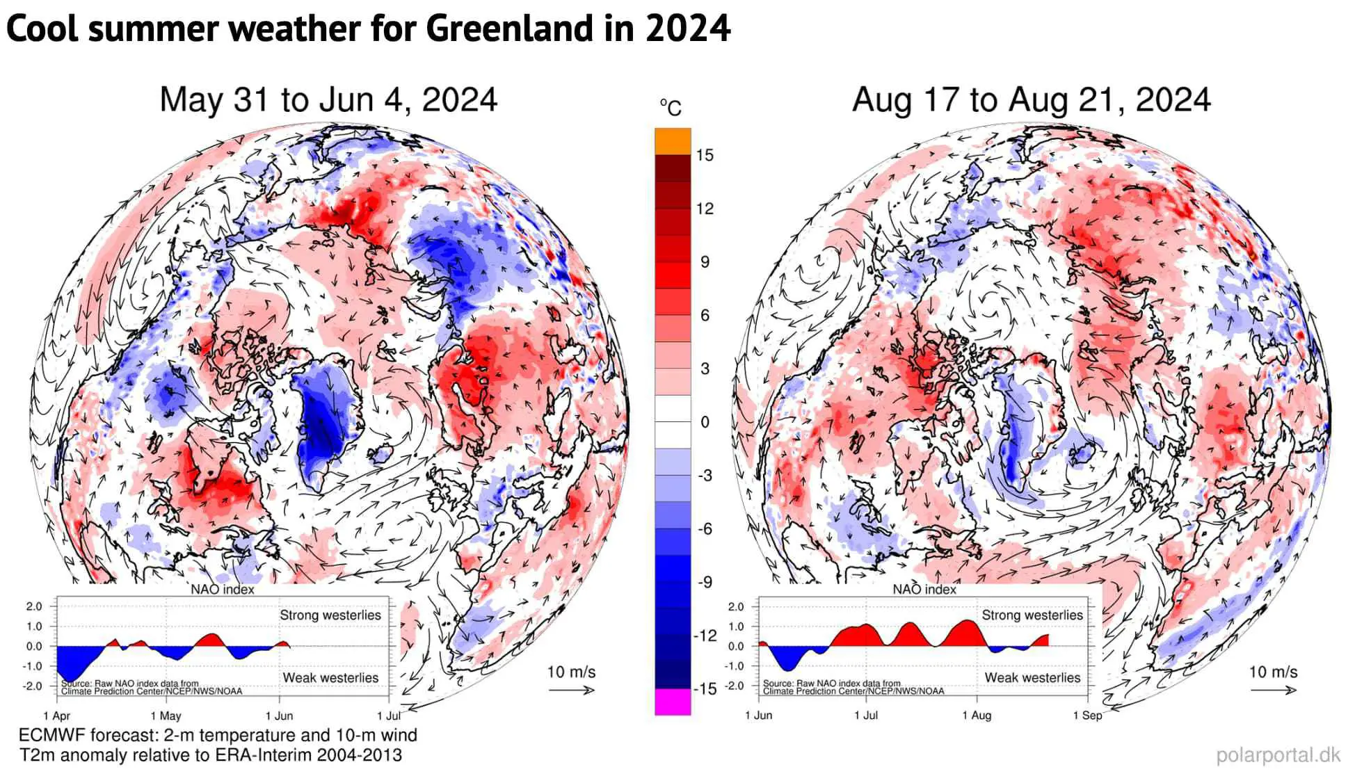
As in previous summer seasons, the comparatively wet and cool spells over the Greenland ice sheet were due to “blocking” weather patterns with ridges over North America and Europe and a trough in between over Greenland.
These high-pressure weather systems have a huge impact on weather extremes. Strong persistent blocks over North America and Europe were present in the course of the summer. This resulted in widespread heat near the cores of these high pressure areas and several heavy rainfall events in various European countries in May and June.
In such a blocked flow, the jet stream is shaped like the Greek capital letter Omega (Ω). With the jet stream bulging up to the north over Canada and northern Europe, troughs of low pressure are found at each “foot” of the omega – including over Greenland.
Svalbard was caught in one the opposite part of the omega with high temperatures and warm air directly over the islands, bringing large amounts of ice melt.
This contrast between Greenland on the one side and Svalbard and the eastern part of Canada is also a common pattern and shows how focusing on extremes in one region of the world means missing out on the opposite extreme in a different region.
The maps below show two examples of these recurring circulation patterns from late May/early June and mid-August. The blue shading shows the cool weather over Greenland (in the centre of the map), while the red shading shows the high temperatures over Canada, Europe and Svalbard .
Snow accumulation
However, the surface mass budget is not just about ice melt.
September, October and November all saw above-average snowfall. Then, as in 2022-23, a rather dry period followed in late winter, followed by spikes in snow in March, April and May.
As a result, the accumulated SMB was close to the 1981-2010 average as melting began.
Subsequently, in June, several large snow fall events brought an emergency blanket back to the ice sheet, delaying the start of the “ablation” – or melt – season to 24 June, 11 days later than the 1981-2010 median. (The ablation season is defined as the first day of three days in a row with an SMB below -1Gt.)
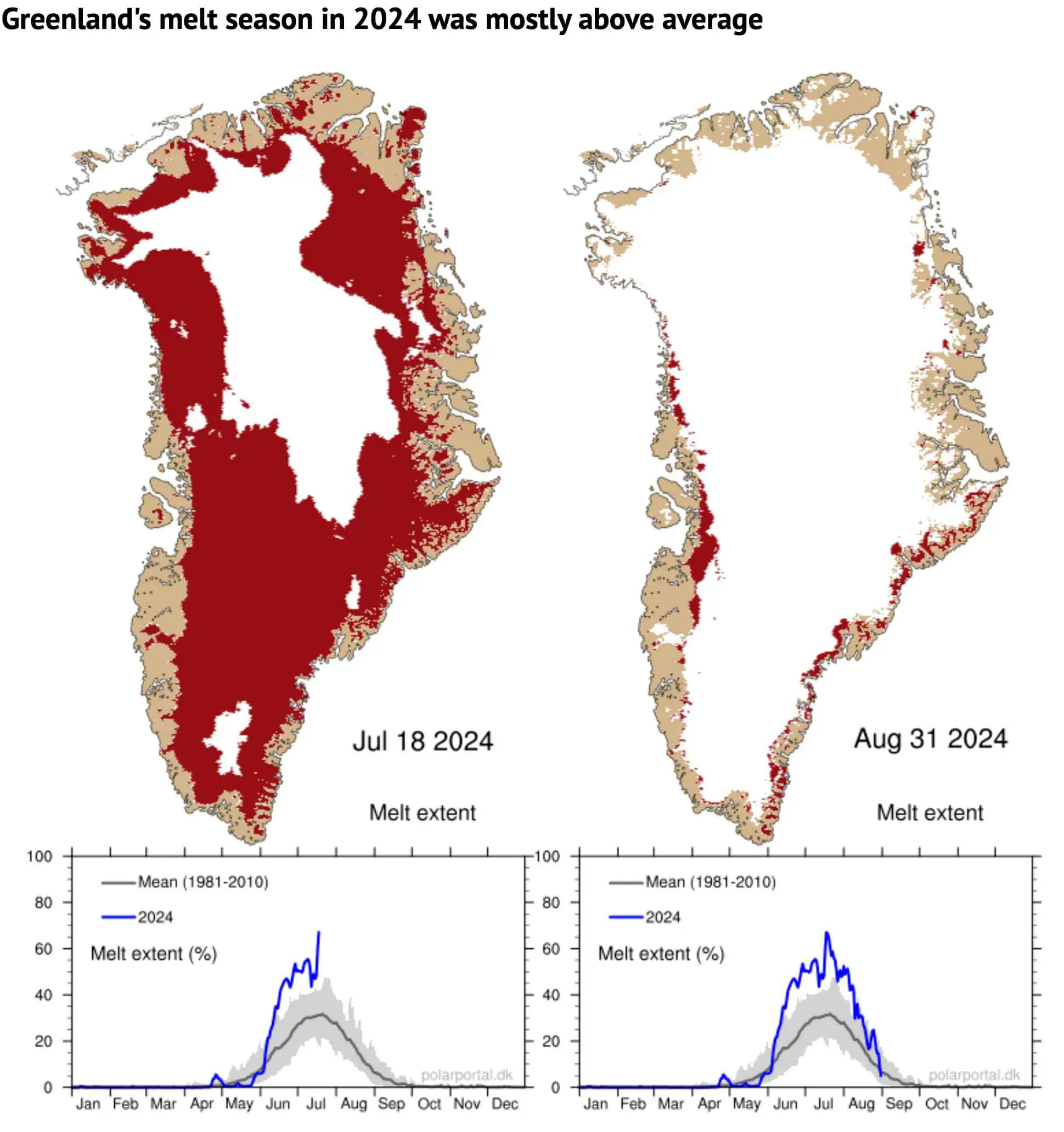
The melt area was well above the average for the period of 1981-2010 during most of June, July and August – despite another spike in snow in August.
The left map shows the area of ice melt on 18 July – the day with the maximum melt extent (67%) of this summer (shaded in red). The map on the right shows the situation at the end of the season on 31 August when the ice sheet was well back into the winter pattern.
The charts beneath show the daily extent of melting across the ice sheet as a percentage (blue line), with the 1981-2010 average shown in grey.
The total mass budget
The surface budget is just one component of the “total” mass budget (TMB) of the Greenland ice sheet:
TMB = SMB + MMB + BMB
Here, MMB is the “marine” mass balance, consisting of the breaking off – or “calving” – of icebergs and the melting of the front of glaciers where they meet the warm sea water. BMB is the “basal” mass balance, which refers to ice losses from the base of the ice sheet. This makes a small, but non-zero, contribution to the TMB and mainly consists of frictional effects and the ground heat flux.
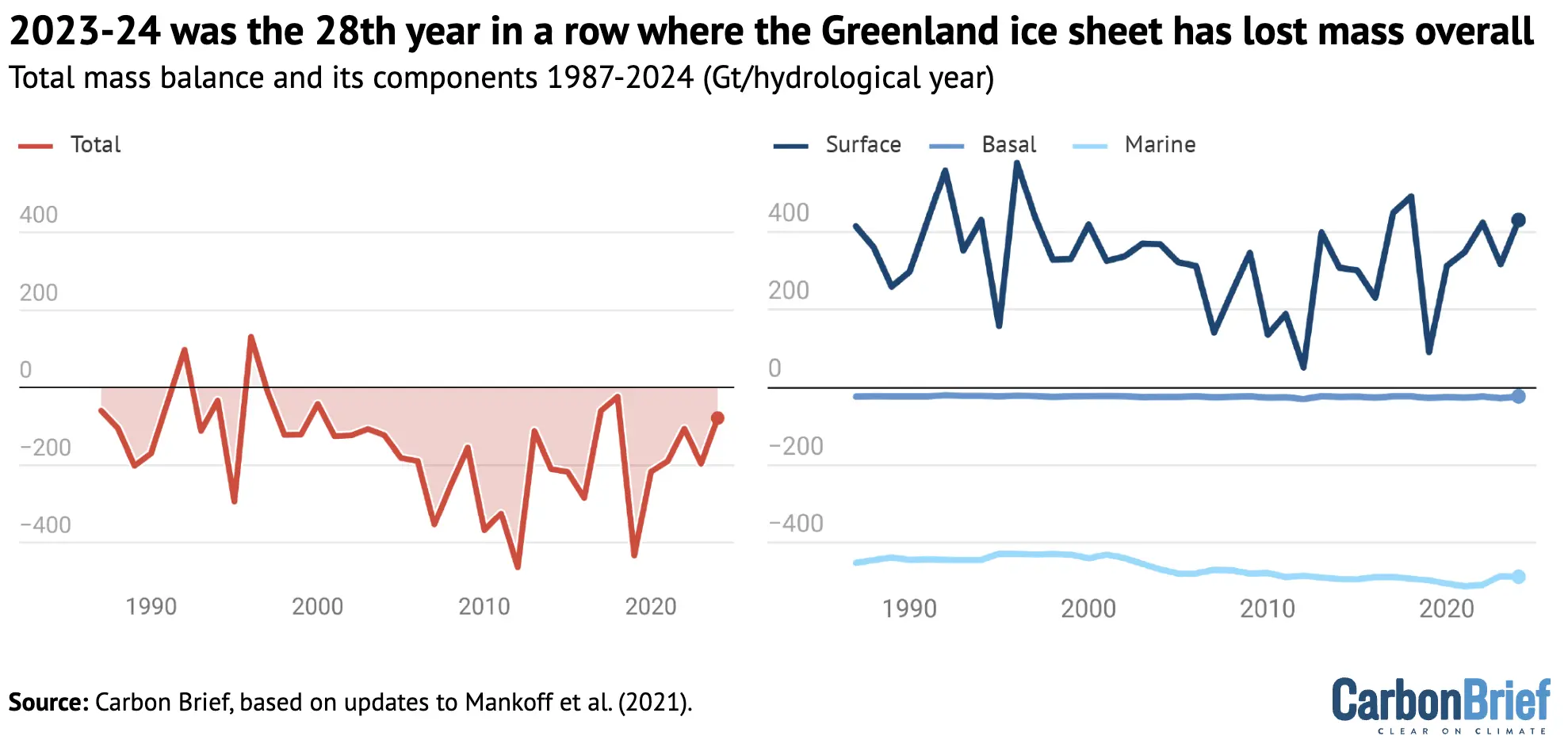
The figure below shows how much ice the Greenland ice sheet has lost (red) going back to 1987, which includes the SMB (blue), MMB (green) and BMB (orange).
For 2023-24, the TMB ended with a loss of 80Gt of ice. This means that 2023-24 was the 28th year in a row with a Greenland ice sheet overall mass loss. As the chart shows, Greenland last saw an annual net gain of ice in 1996.
Satellite data
Using data from the GRACE satellites, we can also estimate how much ice Greenland lost – independently from our calculations above.
The distance of these twin satellites changes slightly due to tiny gravity differences caused by mass changes. In addition, we can measure the speed at which ice flows through control points on the ice sheet where we know the thickness and shape of the ice. Thus, we can estimate MMB, the amount of ice being lost by the process of calving and submarine melting.
This data is openly available, allowing us to monitor the whole ice-sheet budget.
The map and graph below show the gain (blue) and loss (red) in the mass of ice. The difference in these mass changes over a glaciological year (September-August) is the TMB of the ice sheet for that particular year.

According to the GRACE satellite data, most of the ice loss over 2023-24 occurred along the edge of the ice sheet, in particular along the west coast. This is backed up both by PROMICE observations and model data. In the interior of Greenland, a small increase in ice mass is found, as there is usually little or no snow melt in this region.
The graph illustrates the month-by-month development in changes of mass measured in gigatonnes, relative to April 2002. The left axis on the graph shows how this ice mass loss translates into a sea level rise contribution, where 100Gt corresponds to 0.28mm of global sea level rise.
Our calculations and the GRACE satellite data are entirely independent ways of estimating Greenland’s TMB, yet the results are quite closely aligned. From April 2002 to May 2024, the ice sheet losses amounted to 4,756Gt (calculations) and 4,911Gt (satellites) of ice.
As 1Gt of water is equivalent to a cube of 1 km by 1 km by 1 km, 360 of these cubes is equivalent to 1mm of sea level rise averaged around the whole globe.
This means that, since 2002, the Greenland ice sheet alone has contributed around 14mm to global average sea level rise.


The post Guest post: How the Greenland ice sheet fared in 2024 appeared first on Carbon Brief.

When José Antonio Kast took office as Chile’s new president in March, one of his first moves was to put the brakes on plans to expand two protected marine parks – raising doubts about the country’s high-profile bid to host the headquarters of the High Seas Treaty.
But during the UN General Assembly last month, the right-wing leader reaffirmed his leftist predecessor’s ambition for Chile to host the landmark global pact, which came into effect in January and provides a legal framework to protect the waters of the high seas beyond national jurisdiction that cover about two-thirds of the world’s oceans.
Hailing the country’s “maritime vocation”, Kast’s government said the bid to host the treaty’s secretariat in the port city of Valparaíso was state policy and testament to its commitment to multilateralism.
“For the government of Chile, it is of high interest to achieve this recognition, and we will carry out all the efforts to obtain the necessary support,” Foreign Minister Francisco Pérez Mackenna was quoted as saying by local media.
-
At pre-COP, UN climate chief warns of heat threat to mothers and babies
The spotlight on maternal health came on the first day of the pre-COP31 meeting in Fiji, where Pacific concerns are set to top the agenda as ministers gather for talks -
Big banks behind “net zero” alliance continued lending to coal firms
New data shows coal finance has stayed steady at the global level since 2022, as international efforts to cut the ties between lending and emissions faded -
Jordan’s mega-plan for water security risks locking in fossil gas demand
A giant desalination plant will help Jordan confront water scarcity, but solar power’s limited role in the energy-hungry project has raised questions about how climate adaptation finance is being spent


Tough competition from Chinese, Belgian bids
But to garner the votes it needs, Chile must fend off competing bids by Belgium – which has proposed its well-connected capital, Brussels – and China, whose well-funded bid includes the provision of free premises in the coastal city of Xiamen and five years of free utility costs.
Parties to the treaty, formally called the Agreement on Marine Biological Diversity of Areas Beyond National Jurisdiction (BBNJ), will choose the headquarters at their first summit (COP1), in New York from January 11 to January 22, 2027. They will seek consensus, falling back on a two-thirds majority in successive secret ballots.
Chile has offered to provide a restored waterside warehouse “at its own expense” as office space, pitching itself to developing countries as a Global South alternative to Europe-centred Brussels. Among richer countries, it is promoting its democratic credentials and greater transparency as an alternative to China.
Rolling back environmental safeguards at home?
While the South American country remains the top pick among environmental campaigners and other civil society groups, critics of Kast’s government say recent policy moves may make it harder for the country to garner the support it needs.
On March 12, the day after Kast took office, the Environment Ministry withdrew 43 decrees awaiting legal approval, including a push to expand the Mar de Juan Fernández and Nazca-Desventuradas marine parks – vast protected areas in Chile’s Pacific Ocean waters. Both remain under review, the ministry told Climate Home News.
The decrees also included an emission standard for coal power plants and regulations for Chile’s new biodiversity and protected areas service.
A month after holding up the decrees, Kast questioned aspects of Chile’s urban wetlands protection law, suggesting it was sometimes an unjustified obstacle to much-needed housing development, and his administration has also sought to ease the rules on salmon farming in the world’s second-largest producer.
In August, the Constitutional Court struck down the salmon farming reform after a challenge by opposition lawmakers and warnings from green groups including Greenpeace, which said it could help farms relocate into protected areas such as the Kawésqar National Reserve.
Valparaíso mayor Camila Nieto, from former leftist President Gabriel Boric’s party, backs the bid to host the High Seas Treaty, but said she hoped “the government’s support also translates into public policies consistent with the goals of protecting and conserving the oceans”.
“The decisions a country makes on environmental matters can influence international perceptions of its commitment to protecting the oceans. That is something we cannot ignore,” Nieto told Climate Home News.

China’s bid stirs concerns over data access, fishing
Chile’s past record on marine protection – it has protected 43% of its jurisdictional waters – could yet give it an edge.
“Chile deserves it for its conservation record as a state. For more than 15 years Chile has been following this path,” Liesbeth van der Meer, executive director at conservation group Oceana in Chile, told Climate Home News.
Concerns in some quarters about the rival bid by China – for example, over a potential conflict of interest due to the vast Chinese fishing industry – may also weigh in Chile’s favour, experts say.
Chinese-flagged vessels did about 30% of detected high seas fishing between 2022 and 2024, according to an Oceana analysis of Global Fishing Watch data. China also sponsors five of the International Seabed Authority’s 31 deep-sea mining exploration contracts, more than any other country.
The secretariat would host sensitive marine data, making transparency paramount, experts say.
China says hosting the secretariat in Xiamen would help make the treaty more globally representative, fostering cooperation between rich and developing countries and aiding equitable access to marine science and technology.
Wang Yi, China’s minister of foreign affairs, said in a statement that the country has “all along championed true multilateralism” and “firmly defended” UN institutions. Given Xiamen’s $38-billion ocean industry, the city lives up to the treaty’s “significance and promising future”, he added.
Meanwhile, Chile is proposing the treaty’s first high seas marine protected area for the Salas y Gómez and Nazca ridges, a chain of more than 110 seamounts stretching about 4,000 km from off Peru to Rapa Nui (Easter Island) that is rich in endemic fish and other marine species.
The ridges are “a true oasis of productivity”, said Carlos Gaymer, director of the Centre for Ecology and Sustainable Management of Oceanic Islands at Universidad Católica del Norte and co-author of a 2021 scientific review of the area.
The water is so clear that phytoplankton thrive around 200 metres down, feeding zooplankton, small fish and, up the chain, sharks and seabirds. Whales, turtles and sharks use the ridges as “a real highway” across the Pacific, Gaymer said. Parts of the Nazca ridge are likely nursery grounds for jack mackerel and swordfish.
Chile has already asked the body that regulates the industry in the area – the South Pacific Regional Fisheries Management Organisation (SPRFMO) – to close the ridges to all fishing vessels. According to Chilean data, more than 80% of fishing in the area involves Chinese vessels.
Meeting on the Chilean request in early September, SPRFMO’s scientific committee agreed only to recommend closing the area to bottom fishing. SPRFMO’s commission will take the final decision at its next meeting, in early 2027.
For Gaymer, Chile’s push to close the area to fishing should be seen as a “starting point” for the treaty proposal.
“Every time there’s a new expedition, species new to science appear,” Gaymer said. “If you don’t protect areas like these … those species simply disappear from the planet.”
The post Race to host High Seas Treaty HQ heats up as Chile reaffirms bid appeared first on Climate Home News.
Race to host High Seas Treaty HQ heats up as Chile reaffirms bid
Mohamed Adow is the founder and director of Power Shift Africa.
What does it mean to ask a continent to adapt to a crisis it did little to create? For Africa, that question has stopped being philosophical as it is answered every day in flooded communities, failed harvests, disappearing livelihoods and public budgets stretched by disasters they cannot afford.
Africa produces a negligible share of global emissions, but between 1970 and 2021 it accounted for around 35% of climate-related deaths worldwide. The continent is therefore confronting a brutal contradiction that is exemplified by the fact that those who have contributed least to the climate crisis are carrying some of its heaviest costs.
And that explains why, for us, it is worrying that much of the climate debate treats adaptation as a technical exercise. Build better infrastructure, they say. Improve early-warning systems, they urge. Develop drought-resistant crops, they preach. Strengthen disaster preparedness, they yell. All of these things matter, but they do not answer the harder question of why some people and countries are so much more vulnerable in the first place.
At pre-COP, UN climate chief warns of heat threat to mothers and babies
That is the question we have spent the last couple of years trying to answer, and it culminates in our recently launched thought-provoking report that shows how Africa’s vulnerability is not an accident of geography, but has instead been shaped by history, economics and power.
Colonial extraction, unequal development, debt dependency, global economic asymmetries and exclusion from international decision-making have all constrained the resources and choices available to African countries, and climate change is intensifying those existing inequalities, shows the report, titled “A Just Transition for Adaptation: A Framework and Vision for Africa”.
Widening adaptation finance gap
I say it is ‘thought-provoking’ because it asks us to rethink adaptation itself – not as a collection of projects designed to help people cope with climate impacts, but as a question of justice, power and structural change.
That distinction might not sit well with some people, but for Africa it matters, because there is a danger in asking vulnerable countries simply to become more “resilient”. Resilient