Connect with us

Published

on

The past three years have been exceptionally warm globally.

In 2023, global temperatures reached a new high, after they significantly exceeded expectations.

This record was surpassed in 2024 – the first year where average global temperatures were 1.5C above pre-industrial levels.

Now, 2025 is on track to be the second- or third-warmest year on record.

What has caused this apparent acceleration in warming has been subject to a lot of attention in both the media and the scientific community.

Dozens of papers have been published investigating the different factors that could have contributed to these record temperatures.

In 2024, the World Meteorological Organization (WMO) discussed potential drivers for the warmth in a special section of its “state of the global climate” report, while the American Geophysical Union ran a session on the topic at its annual meeting.

In this article, Carbon Brief explores four different factors that have been proposed for the exceptional warmth seen in recent years. These are:

Carbon Brief’s analysis finds that a combination of these factors explains most of the unusual warmth observed in 2024 and half of the difference between observed and expected warming in 2023.

However, natural fluctuations in the Earth’s climate may have also played a role in the exceptional temperatures, alongside signs of declining cloud cover that may have implications for the sensitivity of the climate to human-caused emissions.

An unusually warm three years

Between 1970 and 2014, average surface temperatures rose at a fairly steady rate of around 0.18C per decade.

Set against this long-term trend, temperature increases during the period from 2015 to 2022 were on the upper end of what would be expected.

The increases seen in 2023, 2024 and 2025 were well outside of that range.

The high temperatures of the past three years reflect a broader acceleration in the rate of warming over the past decade.

However, the past three years were unusually warm, even when compared to other years in the 2010s and 2020s.

Record-breaking warmth in 2023 meant that it beat the prior warmest year of 2016 by 0.17C – the largest magnitude of a new record in the past 140 years.

The year 2024 then swiftly broke 2023’s record, becoming the first year where average global temperatures exceeded 1.5C above pre-industrial levels.

The 10 months of data available for 2025 indicates that the year is likely to be slightly cooler than 2023 – though it is possible it may tie or be slightly warmer.

The figure below shows global surface temperatures between 1970 and 2025. (The figures for 2025 include uncertainty based on the remaining three months of the year.)

It includes a smoothed average based on temperature data for 1970-2022 that takes into account some acceleration of warming – and then extrapolates that smoothed average forward to 2023-25 to determine what the expected temperature for those years would have been. (This follows the approach used in the WMO’s “state of the global climate 2024” report.)

Chart showing annual global surface temperatures and the long-term average warming
Global average surface temperature changes between 1970 and 2024 using the WMO average of six groups that report global surface temperature records (dark blue), estimated 2025 temperatures and uncertainties (red) based on the first nine months of the year and a long-term average locally linear smooth (light blue).

This approach calculates how much warmer the past three years were than would be expected given the long-term trend in temperatures.

It shows that 2023 was around 0.18C warmer than expected, 2024 was a massive 0.25C warmer and 2025 is likely to be 0.11C warmer.

Researchers have identified a number of potential drivers of unexpected warmth over 2023-25. Here, Carbon Brief looks at the evidence for each one.

A weirdly behaving El Niño event

El Niño is a climate pattern of unusually warm sea surface temperatures (SSTs) in the tropical Pacific that naturally occurs every two to seven years. Strong El Niño years generally have warmer global temperatures, with the largest effect generally occurring in the months after El Niño conditions peak (when SSTs reach their highest levels in the tropical Pacific).

A relatively strong El Niño event developed in the latter half of 2023, peaking around November before fading in the spring of 2024.

This event was the fourth-strongest El Niño ever recorded, as measured according to SSTs in the Niño 3.4 region in the central tropical Pacific. However, it was notably weaker than the El Niño events in both 1998 and 2016.

This can be seen in the chart below, which shows the strength of El Niño events (red shading) since the 1980s. (The blue shading indicates La Niña events – the opposite part of the cycle to El Niño, which results in cooler SSTs in the tropical Pacific.)
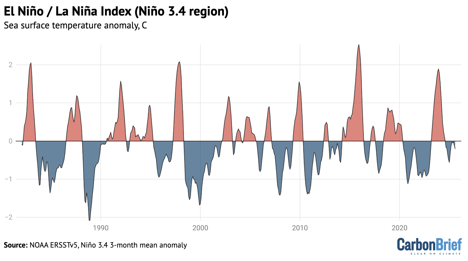
Char showing El Niño and La Niña Index (Niño 3.4 region)
NOAA’s Niño 3.4 region Oceanic Niño Index using detrended data from ERSSTv5.

(It is worth noting that measuring the strength of El Niño events is not entirely straightforward. Other tools used by scientists to monitor changes to El Niño – such as the US National Oceanic and Atmospheric Administration’s (NOAA’s) multivariate ENSO index – show the 2023-24 event was much weaker than indicated in the Niño 3.4 dataset.)

Global surface air temperatures tend to be elevated by around 0.1-0.2C in the six months after the peak of a strong El Niño event – defined here as when SSTs in the Niño 3.4 region reach 1.5C above normal.

The figure below shows the range of global temperature change for the 12 months before and 22 months after the peak of all 10 strong El Niño events since 1950. The light line represents the average of past strong El Niño events, the dark blue line the temperature change observed during the 2023-24 event and the shaded blue area the 5-95th percentile range.
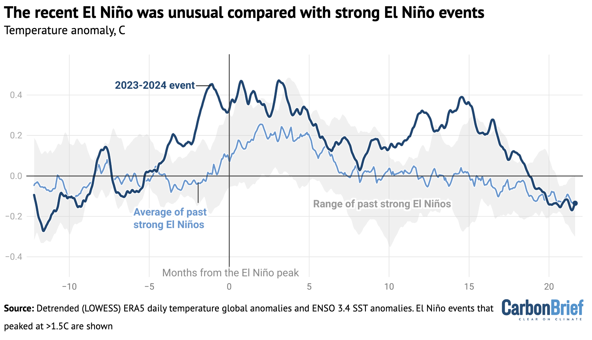
Chart showing that the recent El Niño was unusual compared with strong El Niño events
Global mean surface temperatures for the 12 months prior to peak El Niño conditions and the 22 months following for strong El Niño events. Calculations by Carbon Brief using data from Copernicus/ECMWF’s ERA5 and NOAA’s Oceanic Niño Index.

The figure shows the 2023-24 El Niño was quite unusual compared to other strong El Niño events since 1970. Global temperatures rose to around 0.4C above expected levels – which is on the high side of previous El Niños.

The heat also came early, with high temperatures showing up around four months before the El Niño event peaked. This early heat is unlike any other El Niño event in modern history and is one of the reasons why 2023’s global temperatures were so unexpectedly warm.

Global temperatures remained elevated for a full 18 months after the El Niño peaked, well after conditions in the tropical Pacific shifted into neutral conditions – and even after mild La Niña conditions developed at the end of 2024 and into early 2025.

This figure does not explain how much of this unusual heat was actually caused by El Niño, compared to other factors, but it does suggest that El Niño behaviour alone does not fully explain unusually high temperatures in recent years.

Based on the historical relationship between El Niño and global temperatures, Carbon Brief estimates that El Niño contributed a modest 0.013C to 2023 temperatures and a more substantial 0.128C to 2024 temperatures, albeit with large uncertainties. (See “methodology” section at the end for details.)

However, it is possible that this 2023 estimate is too low. There are some suggestions in the literature that 2023-24 El Niño’s early warmth may have been caused by the rapid transition out of a particularly extended La Niña event. There are indications that temperatures have spiked in similar situations further back in the historical temperature record.

Falling sulphur dioxide emissions

Sulphur dioxide (SO2) is an aerosol that is emitted into the lower atmosphere by the burning of coal and oil. It has a powerful climate cooling effect – Carbon Brief analysis shows that global emissions of SO2 have masked about one-third of historical warming.

Global SO2 emissions have declined around 40% over the past 18 years, as countries have increasingly prioritised reducing air pollution, including through the installation of scrubbers at coal plants.

These declines have been particularly concentrated in China, which has seen a 70% decline in SO2 emissions since 2007. In addition, a rule introduced for international shipping in 2020 by the International Maritime Organization (IMO) has resulted in an 80% decline in the sulphur content of shipping fuel used around the world.

The decline of SO2 emissions is shown in the figure below.

Chart showing that China and international shipping are large drivers of recent SO2 emissions decline
Annual SO2 emissions from China, international shipping and the rest of the world. Data from the Community Earth atmospheric Data System (CEDS).

Shipping in particular has been suggested as a potential culprit for recent temperatures, given that ships emit SO2 over oceans where the air tends to be cleaner and so emissions have a bigger effect.

Seven of the eight studies that have explored the temperature impact of the IMO regulations have suggested a relatively modest effect, in the range of 0.03-0.08C. However, one study – led by former NASA scientist Dr James Hansen – calculated a much stronger effect of 0.2C that would explain virtually all the unusual warmth of recent years.

The figure below shows Carbon Brief’s estimate of the global average surface temperature changes caused by the low-sulphur shipping fuel rules, using the estimates produced by all eight studies. The central estimate (dark blue line) is relatively low, at around 0.05C, but the uncertainty range (light blue shading) across the studies remains large.
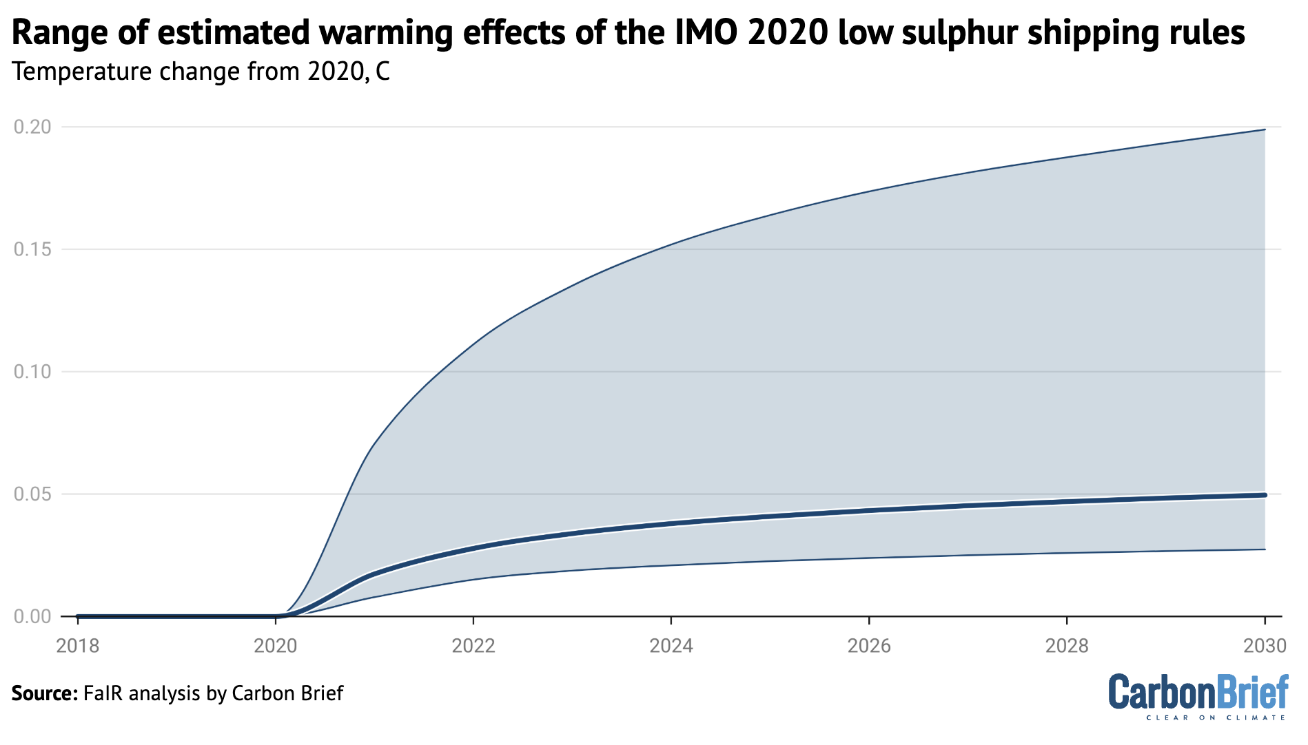
Chart showing the range of estimated warming effects of the IMO 202 low sulphur shipping rules
Range (5th to 95th percentile) and central estimate (50th percentile) of simulated global average surface temperature responses to the IMO 2020 regulations across the radiative forcing estimates in the literature. Analysis by Carbon Brief using the FaIR model.

Overall, Carbon Brief’s analysis finds that around 0.04C of warming over 2020-23 and 0.05C of warming over 2020-24 can be attributed to SO2 declines from shipping and other sources.

However, this approach might slightly overstate the effects of SO2 on the exceptional temperatures of the past three years, as shipping and other SO2 declines would have had some effect on 2021 and 2022 as well.

It is also worth noting that the total effects of SO2 declines on global temperatures have been considerably larger and are estimated to be responsible for around one-quarter of all warming since 2007.

However, these SO2 decreases occurred over a long period of time and do not clearly explain the recent spike in temperatures.

An unusual volcanic eruption in Tonga

In early 2022, the Hunga Tonga-Hunga Ha’apai underwater volcano erupted spectacularly, sending a plume 55km into the atmosphere. This was by far the most explosive volcanic eruption since Mount Pinatubo erupted in 1991.

This was a highly unusual volcanic eruption, which vaporised vast amounts of sea water and lofted it high into the atmosphere. Overall, around 146m metric tonnes of water vapour ended up in the stratosphere, which is the layer of the atmosphere above the troposphere.

Water vapour is a powerful greenhouse gas. While it is short-lived in the lower atmosphere, it can stick around for years in the stratosphere, where it has a significant warming effect on the climate.

The figure below shows the concentration of water vapour in the stratosphere between 2005 and mid-2025. It shows how the 2022 eruption increased atmospheric concentrations of the greenhouse gas by around 15%. More than half the added water vapour has subsequently fallen out of the upper atmosphere.
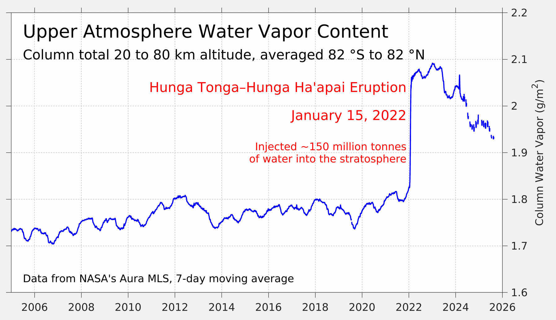
Chart showing upper atmosphere water vapour content
Upper atmosphere water vapor content from NASA’s Aura MLS satellite. Figure from Dr Robert Rohde.

Most early studies of the Hunga Tonga-Hunga Ha’apai volcano focused specifically on the effects of stratospheric water vapour. These tended to show strong warming in the lower stratosphere and cooling in the middle-to-upper stratosphere, but only a slight warming effect on global surface temperatures of around 0.05C.

Hunga Tonga-Hunga Ha’apai had much lower sulphur emissions than prior explosive eruptions, such as Pinatubo and El Chichon. However it put 0.51.5m tonnes of sulphur into the stratosphere – the most from an eruption since Pinatubo.

Studies that included both sulphur and water vapour effects tend to find that the net effect of the eruption on surface temperatures was slight global cooling, concentrated in the southern hemisphere.

By using the estimates published in a 2024 study published in Geophysical Research Letters, which used the FaIR climate emulator model, Carbon Brief estimates that the Hunga Tonga-Hunga Ha’apai eruption cooled global surface temperatures by -0.01C in 2023 and -0.02C in 2024.

This suggests that the eruption was likely only a minor contributor to recent global surface temperatures.

A stronger-than-expected solar cycle

The source of almost all energy on Earth is the sun. Over hundreds of millions of years, variations in solar output have a big impact on the global climate.

Thankfully, over shorter periods of time the sun is remarkably stable, helping keep the Earth’s climate habitable for life. (Big changes – such as ice ages – have more to do with variations in the Earth’s orbit than changes in solar output.)

However, slight changes in solar output do occur – and when they do, they can influence climate change over shorter periods of time. The most important of these is the roughly 11-year solar cycle, which is linked with the sun’s magnetic field and results in changes in the number of sunspots and amount of solar energy reaching Earth.

The figure below shows a best-estimate of changes in total solar irradiance since 1980, based on satellite observations. Total solar irradiance is a measure of the overall amount of solar energy that reaches the top of the Earth’s atmosphere and is measured in watts per metre squared.
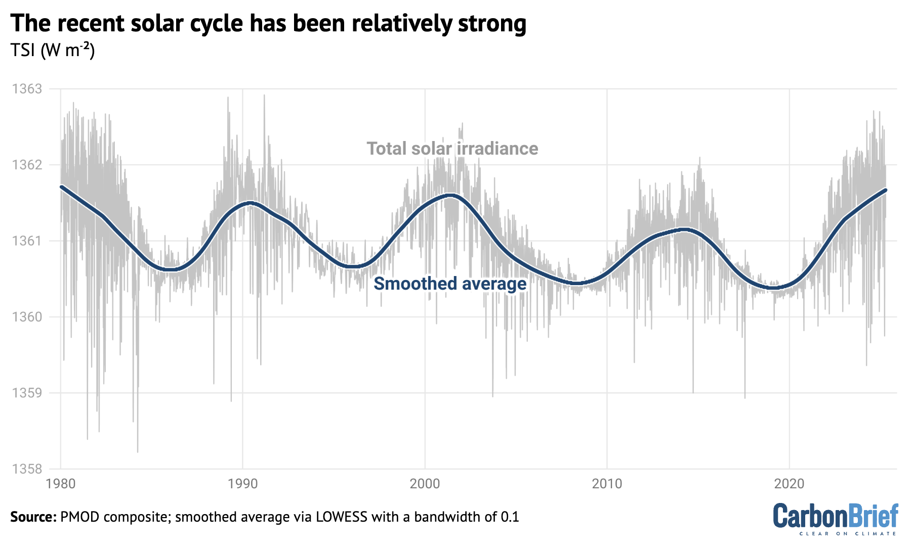
Chart showing the recent solar cycle has been relatively strong
Total solar irradiance from the PMOD composite (blue) along with a smoothed average (red) from 1980 to 2025.

The 11-year solar cycle is relatively modest compared to the sun’s total output, varying only a few watts per metre squared between peak and trough – amounting to around 0.01% of solar output. However, these changes can result in variations of up to 0.1C in global temperatures within a decade.

The most recent solar cycle – solar cycle 25 – began around 2020 and has been the strongest solar cycle measured since 1980. It was stronger than most models had anticipated and likely contributed to around 0.04C global warming in 2023 and 0.07C in 2024.

Putting together the drivers

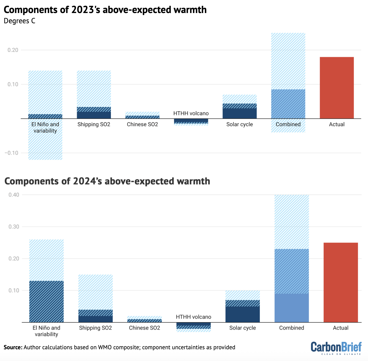
By combining earlier estimates of different factors contributing to 2023 and 2024 global surface temperatures, about half of 2023’s unusual warmth and almost all of 2024’s unusual warmth can be effectively explained.

This is illustrated in the figure below, which shows the five different factors discussed earlier – El Niño, shipping SO2, Chinese SO2, the Hunga Tonga-Hunga Ha’apai volcano and solar cycle changes – along with their respective uncertainties.

The sum of all the factors is shown in the “combined” bar, while the actual warming compared to expectations is shown in red.

The upper chart shows 2023, while the lower one shows 2024.
Charts showing the components of 2023 and 2024's above-expected warmth
Attribution of 2023 and 2024 anomalous warmth. Blue bars show individual factors and their uncertainties, the orange bar shows the combined effects and combination of uncertainties and the green bar shows the actual warming compared with expectations. Adapted from Figure 12 in WMO’s state of the global climate 2024 report.

It is important to note that the first bar includes both El Niño and natural year-to-year variability; the height of the bar reflects the best estimate of El Niño’s effects, while the uncertainty range encompasses year-to-year variability in global temperatures that may be – at least in part – unrelated to El Niño.

The role of natural climate variability

Large natural variability to the Earth’s climate is one of the main reasons why the combined value of the different drivers of expected warmth in 2023 has an uncertainty range that exceeds the observed warming – even though the best-estimate of combined factors only explains half of temperatures.

Or, to put it another way, there is up 0.15C difference in global temperatures year-on-year that cannot be explained solely by El Niño, human-driven global warming, or natural “forcings” – such as volcanoes or variations in solar output.

The figure below shows the difference between actual and expected warming in the global temperature record for every year in the form of a histogram. The vertical zero line represents the expectation given long-term global warming and the other vertical lines indicate the warming seen in 2023, 2024 and 2025.

The height of each blue bar represents the number of years over 1850-2024 when the average global temperature was that far (above or below) the expected level of warming. 
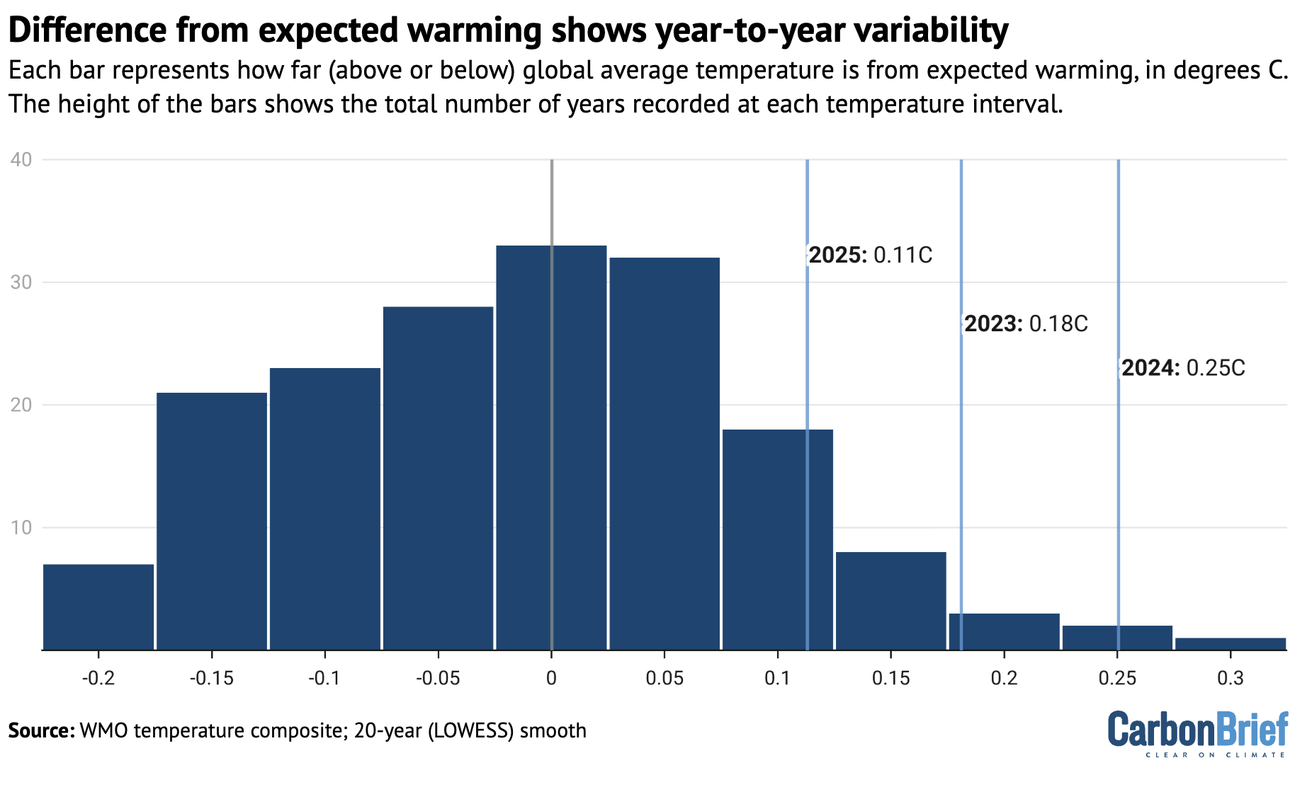
Chart showing that the difference from expected warming shows year-to-year variability
Histogram of residuals between actual and expected warming for all years since 1850, with the values for the past three years highlighted. Expected warming based on a 20-year locally linear smooth of the data.

Based on the range of year-to-year variability, temperatures would be expected to spike as far above the long-term trend as they did in 2023 once every 25 years, on average. The year 2024 would be a one-in-88 year event, whereas 2025 would be a less-unusual, one-in-seven year event.

These likelihoods for the past three years are sensitive to the approach used to determine what the longer-term warming level should be.

In this analysis, Carbon Brief used a local smoothing approach (known as locally estimated scatterplot smoothing) to determine the expected temperatures, following the approach used in the WMO “state of the climate 2024” report.

This approach results in a warming of 1.28C in 2023 and 1.30C in 2024, against which observed temperatures are compared.

Other published estimates put the longer-term warming in 2024 notably higher.

Earlier this year, the scientists behind the “Indicators of Global Climate Change” (IGCC) report estimated that human activity caused 1.36C of recent warming in 2024. They also found a slightly lower overall warming level for 2024 – 1.52C, as opposed to the WMO’s 1.55C – because they looked exclusively at datasets used by IPCC AR6. (This meant estimates from the Copernicus/ECMWF’s ERA5 dataset were not included.)

Based on climate simulations, the IGCC report finds the likelihood of 2024’s warmth to be a one-in-six year event and 2023’s a one-in-four event.

Using the same assumptions as the IGCC, Carbon Brief’s approach calculates that 2024 would be a less-common, one-in-18 year event.

However, the IGCC estimate of current human-induced warming is based on the latest estimates of human and natural factors warming the climate. That means that it already accounts for additional warming from low-sulphur shipping fuel, East Asian aerosols and other factors discussed above.

Therefore, the results from these two analyses are not necessarily inconsistent: natural climate variability (including El Niño) played a key role – but this came in addition to other factors. Natural fluctuations in the Earth’s climate alone would have been unlikely to result in the extreme global temperatures seen in 2023, 2024 and 2025.

A cloudy picture

Even if unusual recent global warmth can be mostly attributed to a combination of El Niño, falling SO2 emissions, the Hunga Tonga-Hunga Ha’apai volcano, solar cycle changes and natural climate variability, there are a number of questions that remain unanswered.

Most important is what the record warmth means for the climate going forward. Is it likely to revert to the long-term average warming level, or does it reflect an acceleration in the underlying rate of warming – and, if so, what might its causes be?

As explained by Carbon Brief in a 2023 article, climate models have suggested that warming will speed up. Some of this acceleration is built into the analysis presented here, which includes a slightly faster rate of warming in recent years than has characterised the period since 1970.

But there are broader questions about what – beyond declining SO2 and other aerosols – is driving this acceleration.

Research recently published in the journal Science offered some potential clues. It found a significant decline in planetary reflectivity – known as albedo – over the past decade, associated with a reduced low-level cloud cover that is unprecedented in the satellite record.

The authors suggest it could be due to a combination of three different factors: natural climate variability, changing SO2 and other aerosol emissions and the effects of global warming on cloud reflectivity.

Natural climate variability seems unlikely to have played a major role in reduced cloud cover, given that it was relatively stable until 2015. However, it is hard to fully rule it out given the relatively short satellite record.

Reductions in SO2 emissions are expected to reduce cloud reflectivity, but the magnitude of the observed cloud reflectivity changes are much larger than models simulate.

Models might be underestimating the impact of aerosols on the climate. But, if this were the case, it would indicate that climate sensitivity might be on the higher end of the range of model estimates, because models that simulate stronger aerosol cooling effects tend to have higher climate sensitivity.

Finally, cloud cover might be changing and becoming less reflective as a result of warming. Cloud responses to climate change are one of the largest drivers of uncertainty in future warming. One of the main reasons that some climate models find a higher climate sensitivity is due to their simulation of less-reflective clouds in a warming world.

The Science study concludes that the 2023 heat “may be here to stay” if the cloud-related albedo decline was not “solely” caused by natural variability. This would also suggest the Earth’s climate sensitivity may be closer to the upper range of current estimates, it notes.

Methodology

Carbon Brief built on work previously published in the IGCC 2024 and WMO state of the global climate 2024 reports that explores the role of different factors in the extreme temperatures in 2023, 2024 and 2025.

The impact of El Niño Southern Oscillation (ENSO) on the temperatures was estimated using a linear regression of the annual mean global temperature anomaly on the Feb/Mar Niño 3.4 index. This resulted in an impact of −0.07C, 0.01C and 0.13C for 2022, 2023 and 2024 respectively (with a 95% confidence interval of ±0.13 ºC).

It is important to note that the uncertainties in the ENSO response estimated here also incorporate other sources of unforced internal (modes of variability in other basins such as AMV), and potentially some forced variability. The bar in the combined figure is labelled “El Niño and variability” to reflect this.

For details on calculations of the temperature impact of shipping and Chinese SO2 declines, see Carbon Brief’s explainer on the climate impact of changing aerosol emissions.

Solar cycle 25 was both slightly earlier and slightly stronger than prior expectations with a total solar irradiance anomaly of 0.97 watts per metre squared in 2023 relative to the mean of the prior 20 years. This resulted in an estimated radiative forcing of approximately 0.17 watts per metre squared and an estimated global surface temperature increase of 0.07C (0.05C to 0.10C) with a one- to two-year lag based on a 2015 study. Thus, the impact on 2023 and 2024 is around 0.04C and 0.07C, respectively (+/- 0.025C). This is a bit higher warming than is given by the FaIR model, as the 2015 study is based on global models that have ozone responses to the UV changes, which amplifies the temperature effects a bit.

The Hunga Tonga-Hunga Haʻapai volcanic eruption added both SO2 and water vapour to the stratosphere (up to 55km in altitude). The rapid oxidation of SO2 to sulphate aerosol dominated the radiative forcing for the first two years after the eruption. As a result, the net radiative forcing at the tropopause was likely negative; −0.04 watts per metre squared and −0.15 watts per metre squared in 2022 and 2023, respectively, implying a temperature impact of -0.02C (-0.01C to -0.03C) calculated using the FaIR model.


The post Analysis: What are the causes of recent record-high global temperatures? appeared first on Carbon Brief.

Analysis: What are the causes of recent record-high global temperatures?

Continue Reading

Climate Change

Woodside’s own modelling reveals catastrophic oil spill risk at Scott Reef

Published

on

What if Australia’s worst offshore oil spill hasn’t happened yet?

I’m terrified by the thought.

Our new report in partnership with Environs Kimberley analyses Woodside’s own oil spill modelling and it reveals a worst-case blowout at the corporation’s proposed Browse gas project at Scott Reef could be up to 30 times larger than the Montara oil spill – one of Australia’s worst environmental disasters to date.

Woodside’s own modelling warns that oil pollution could spread across Scott Reef, the Kimberley coast and beyond, with impacts Woodside itself describes as “severe”, “potentially irreversible” and “catastrophic”.

Montara oil spill
Montara oil field on fire © A Crude Injustice

What’s at stake?

Scott Reef really is like nowhere else on Earth.

Scott Reef is Australia’s largest freestanding oceanic reef, a pristine marine ecosystem that has thrived for around 15 million years. About 270 kilometres off the Kimberley coast, it supports more than 2,000 marine species, including endangered pygmy blue whales, nesting green sea turtles, the endangered dusky sea snake and ancient corals.

Yet Woodside wants to drill up to 57 toxic wells around and underneath it, causing decades of deafening seismic blasting, light and noise pollution, shipping traffic and, of course, the risk of a ‘catastrophic’ oil spill.

fish shoals at scott reef

What did Woodside’s modelling find?

Before Browse can be approved, Woodside is required to assess what could happen if something goes wrong. We analysed the corporation’s own environmental assessment documents, and the findings are deeply concerning.

Woodside’s modelling shows that the most severe Browse scenario would be the worst oil spill in Australian history, releasing up to 893,739 barrels of condensate into the Timor Sea. For context, the Montara oil spill released 30,000 barrels of oil.

A blowout of this scale could see oil spread hundreds of kilometres, reaching some of Australia’s most important marine environments, extending into Indonesian and Timor-Leste waters and even washing up along parts of the Kimberley coast. Entrained oil – oil mixed throughout the water column – is predicted to travel up to 863 kilometres from the spill site.

The modelling identifies potential impacts to at least nine marine parks, eight reefs and three Indigenous Protected Areas, as well as important habitats for endangered species, including pygmy blue whales, green sea turtles, seabirds and other marine life.

The potential Browse oil spill reach and the marine parks at risk © Greenpeace

These aren’t just places on a map. They are globally significant marine ecosystems that support ancient coral reefs, endangered wildlife, tourism, fisheries and coastal communities. A spill of this scale wouldn’t simply affect one reef; it has the potential to impact an entire connected marine ecosystem.

Why this matters now

The most important thing is that Browse has not yet been approved. That means there is still time to stop Browse and the serious risks outlined in Woodside’s own modelling.

The science has been done. The risks have been modelled. The decision now rests with the Australian Government.

Governments are often forced to respond after environmental disasters happen. This is one of those rare moments where they have the opportunity to act before one does.

What you can do

Together, we still have the power to stop Woodside and save Scott Reef.

You can help by:

The more people who support saving Scott Reef, the harder it is for governments to approve Woodside’s drilling plans – Browse.

Together, we can ensure a reef that has existed for millions of years is known for its incredible biodiversity – not as the site of Australia’s worst oil spill.

Let’s save Scott Reef.

What if Australia’s worst offshore oil spill hasn’t happened yet?

Continue Reading

Climate Change

REPORT: ‘Catastrophic” Browse Oil Spill Report

Published

on

Analysis by Greenpeace and Environs Kimberley shows that a severe oil spill at Scott Reef could be the worst in Australian history — Woodside has labeled the impact of such a spill ‘catastrophic’.

According to the fossil fuel company the impacts to Scott Reef ‘would likely be severe and potentially irreversible’. Oily pollution could reach as far as the Kimberley coast to the coasts of Indonesia and Timor Leste while endangered marine species live, breed, forage and migrate within the potential disaster zone: whales, seabirds, turtles and other marine life are all at risk.

Report Summary

GPAP illustration of a 'worst case' senario oil spill based on Woodside's own modeling.
GPAP illustration of a ‘worst case’ senario oil spill based on Woodside’s own modeling.

Key Findings

  • The most severe Browse scenario would be the worst oil spill in Australian history – up to 30 times bigger than the 2009 Montara oil spill disaster. According to Woodside, the environmental impact of such a spill would be ‘catastrophic’.
  • Scott Reef and Sandy Islet could be covered in oily pollution. Woodside has conceded that the impacts to Scott Reef from a major spill ‘would likely be severe and potentially irreversible’.
  • A blowout of this scale could see oil washing up on the Western Australian Kimberley Coast, and affect at least nine marine parks, eight reefs, three Indigenous Protected Areas, and several islands in Australian, Indonesian and Timor Leste waters.
  • Endangered and vulnerable marine species live, breed, forage and migrate within the potential disaster zone: whales, seabirds, turtles and other marine life are all at risk.
  • A Browse oil spill threatens important tourism, diving, surfing and fishing hotspots, with potential ‘long term impacts’ for tourism operators in the Kimberley or visiting Rowley Shoals or Scott Reef.
Browse and Montara: Location and extent in the Timor Sea: GPAP illustration based on maps from ‘The Montara Oil Spill: A 2009 Well Blowout in the Timor Sea’ and a Browse loss of well containment.

Scott Reef: An ancient oceanic reef system

Scott Reef, located around 270 kilometres off the Western Australian Kimberley coast, is one of Australia’s largest oceanic reef systems. Ancient Scott Reef has been thriving for 15 million years, having adapted to changing seas. Today, it is a haven for marine life, providing vital habitat for more than a thousand species, including corals, fish, sharks and rays.

The deep waters surrounding the reef are home to 29 known species of whale and dolphin, including endangered pygmy blue whales, which travel along the Western Australian coast and stop at Scott Reef during their annual migration to forage and feed. The dusky sea snake, also classified as endangered, lives at Scott Reef. Sandy Islet, part of Scott Reef, is a nesting ground for a small population of genetically distinct green sea turtles, a species classified as vulnerable.

If Woodside, Australia’s largest oil and gas company, were to gain approval to drill for gas at Scott Reef, the ecosystem would face a barrage of industrial impacts, including seismic blasting, gas flaring, underwater noise, artificial lighting, pipe- laying, and fast-moving vessels over years of construction and operation. Add to that the risk of a major oil spill that could be Australia’s worst environmental disaster, with consequences spreading far beyond Scott Reef.

GPAP illustration of drilling sights at Scott Reef.

A disaster worse than Montara, according to Woodside itself

” Woodside’s ‘worst case’ scenario is a blowout at the Torosa gasfield, directly under Scott Reef.”

People, places and wildlife at risk

Woodside’s modelling shows that an oil spill at Scott Reef could affect eight reefs, at least nine marine parks and three Indigenous Protected Areas. In the event of a worst-case oil spill, Scott Reef and Sandy Islet, being closest to the wellhead, would be worst affected.

Woodside’s modelling finds that the impacts to Scott Reef from a major spill like this ‘would likely be severe and potentially irreversible’. The impacts of an oil spill are not confined to Scott Reef – according to Woodside’s modelling, ‘hydrocarbon spills resulting from the proposed Browse to NWS Project have the potential to significantly impact shoreline habitats at Scott Reef, Ashmore Reef, Cartier Island and Rowley Shoals.’

Oil from a blowout could also reach neighbouring countries, including Pulau Rote, Savu, Sumba and West Timor in Indonesia, and Timor Leste. This is not an exhaustive list of all places that could be affected by an oil spill at Scott Reef. Once oil hits the water, its spread is influenced by the wind, tides, currents and other external conditions. An oil spill from the Browse project could have a less or more severe impact than the modelling indicates. Equally, Woodside cannot rule out other sites being affected.

A disaster for marine life

Woodside’s oil spill modelling shows that a blowout from the Browse project would put whales, turtles, seabirds, coral, significant feedstocks such as plankton and seagrass, fish, dolphins and other marine life at risk. According to Woodside, a Browse oil spill would:

  • Directly threaten the coral at Scott Reef, with ‘potential for near total coral mortality in the worst affected areas’; a severe spill could also harm coral at Seringapatam Reef and the Rowley Shoals.
  • ‘Significantly impact’ the plankton, seagrass and macroalgae that support the entire food chain.
  • ‘Significantly impact bird species, including protected species’, which are ‘particularly vulnerable’ to oil spills.

A spill would not only threaten birds at Scott Reef, but those that nest or breed at Ashmore Reef and Cartier Island, Browse Island, islands along the Kimberley coastline (such as the Lacepede Islands) and Rowley Shoals. Woodside’s oil spill modelling specifically notes the potential risk to thirteen species of seabirds.

Oil spills also threaten whales and other cetaceans, especially concentrations of oil on the surface of the water. This can cause ‘sublethal and lethal effects’, especially when feeding, as whales and other marine mammals have been found to aspirate oil when breathing through an oil slick at the sea surface, thus absorbing hydrocarbons directly into their lungs, leading to sublethal and lethal impacts.

According to Woodside’s modelling, a Browse oil spill could be particularly harmful to the spinner dolphins living at Scott Reef with the potential for ‘a significant portion of this local population to be impacted in the event of a worst-case hydrocarbon spill’.

Marine reptiles, including the green sea turtles found at Scott Reef, are also at risk. Woodside’s modelling warns that an oil spill could cause ‘significant mortality amongst adults and hatchlings’, leading to ‘the potential for longer-term impacts on the Scott Reef – Browse Island genetic stock of green turtles’. Further, an oil spill could have lasting impacts on the breeding populations of olive ridley turtles, flatback turtles and hawksbill turtles. Essentially, all marine life found at or near the sea surface could be impacted by such a spill.

GPAP illustration of pygmy blue whale and humpback whale migration path through Scott Reef and a 'worst case' oil spill senario based on Woodside's own modeling.
GPAP illustration of pygmy blue whale and humpback whale migration path through Scott Reef and a ‘worst case’ oil spill senario based on Woodside’s own modeling.

Woodside cannot be trusted

In Woodside’s inadequate response plan, Woodside states that it considers an oil spill to be ‘highly unlikely’ and the threat to the environment and wildlife to be ‘acceptable’. We do not believe these are credible assertions. For instance, the WA Environmental Protection Authority (EPA), which is assessing Woodside’s Browse to NWS proposal, did not agree. In August 2024, it emerged that the EPA advised Woodside that its Browse development posed ‘unacceptable’ risks to WA’s environment.

A potential oil spill from the Torosa field was one of the risks cited by the EPA in its preliminary decision not to approve the project. Woodside has subsequently revised its plans to drill for gas at Scott Reef, proposing to use unproven new technology that the company claims would bring a spill under control more quickly, reducing the spill time from 77 days to 13 days.

However, an independent assessment commissioned by Woodside did not support these claims. Instead, the expert questioned whether the piece of equipment proposed by Woodside — a capping stack — could be deployed in practice, and the time it would likely take to do so.

While Woodside has also claimed that a ‘pyrotechnic shear ram’ would reduce the spill time to as little as 24 hours, the company’s expert noted that this had yet to be ‘used in anger’ and that ‘there remains a risk’ that it fails to function.

Woodside’s alarming track record

Woodside’s stated ability to prevent or control a disaster is undercut by its poor environmental and safety track record. There have been numerous incidents at Woodside’s facilities over the last decade threatening the safety of its workers and the environment. These include:

  • Whale calf collision: In August 2023, a tugboat operated by a Woodside contractor hit a whale calf in the Port of Dampier. The incident was only confirmed by the Department of Biodiversity, Conservation and Attractions (DBCA) after media inquiries.
  • Explosion at Pluto LNG plant: In May 2023, an explosion forced Woodside to shut down and evacuate its Pluto LNG facility. Woodside was accused by unions of downplaying the incident. Eighteen months later, Woodside was again forced to put Pluto LNG into an emergency shutdown after the control systems failed.
  • Oil spill near Ningaloo: In May 2025, Woodside spilled 16,000 litres of ‘hydrocarbons’ into the ocean near World Heritage listed Ningaloo Reef while decommissioning its Griffin facility. Three months later, the government regulator ordered Woodside to stop decommissioning operations at Griffin and nearby Stybarrow following a series of ‘preventable health and safety incidents’ at both sites.
  • Oil spill in Cossack field: In 2016, a Woodside oil rig in the Cossack field leaked over 10,500 litres of oil into the ocean due to a degraded seal.
  • Northern Endeavour clean-up debacle: Woodside evaded a $362 million decommissioning bill for its Northern Endeavour oil platform in the Timor Sea by offloading it onto a one-person operation. When the buyer went bankrupt, the Federal Government had to step in, eventually putting a levy on offshore oil and gas companies to recover the clean up costs.
  • Cost-cutting and corrosion: In 2021, Woodside announced a 30% cut in operating costs, focusing on maintenance, despite repeated warnings from the government regulator about corrosion at its oil and gas facilities. The warnings continued. In July 2023, the regulator blamed Woodside’s ‘inadequate maintenance’ for serious corrosion of the flare bridge and support structure at its North Rankin complex.
  • Abandoned infrastructure: Woodside finished extracting oil from the Enfield field in 2018. In 2019, the government regulator ordered Woodside to remove the Nganhurra Riser Turret Mooring (RTM), an 83-metre-long, 2,452 tonne piece of infrastructure. Woodside instead tried to sink the RTM near the World Heritage-listed Ningaloo Reef. After a public outcry, Woodside finally removed the RTM in October 2023.

A lasting legacy for our oceans: Save Scott Reef from Woodside’s pollution

Woodside’s Browse proposal to drill for oil and gas presents unacceptable risks to Scott Reef and the web of life it supports from Western Australia to Indonesia.
Greenpeace Australia Pacific and Environs Kimberley are calling on the WA and Federal Governments to save Scott Reef by rejecting Woodside’s Browse project once and for all.

What you can do

Together, we still have the power to stop Woodside and save Scott Reef.

You can help by:

REPORT: ‘Catastrophic” Browse Oil Spill Report

Continue Reading

Climate Change

Browse Oil Spill Report

Published

on

Analysis by Greenpeace and Environs Kimberley shows that a severe oil spill at Scott Reef could be the worst in Australian history — Woodside has labeled the impact of such a spill ‘catastrophic’. According to the fossil fuel company the impacts to Scott Reef ‘would likely be severe and potentially irreversible’. Oily pollution could reach as far as the Kimberley coast to the coasts of Indonesia and Timor Leste while endangered marine species live, breed, forage and migrate within the potential disaster zone: whales, seabirds, turtles and other marine life are all at risk.

GPAP illustration of a ‘worst case’ senario oil spill based on Woodside’s own modeling.

Key Findings

  • The most severe Browse scenario would be the worst oil spill in Australian history – up to 30 times bigger than the 2009 Montara oil spill disaster. According to Woodside, the environmental impact of such a spill would be ‘catastrophic’.
  • Scott Reef and Sandy Islet could be covered in oily pollution. Woodside has conceded that the impacts to Scott Reef from a major spill ‘would likely be severe and potentially irreversible’.
  • A blowout of this scale could see oil washing up on the Western Australian Kimberley Coast, and affect at least nine marine parks, eight reefs, three Indigenous Protected Areas, and several islands in Australian, Indonesian and Timor Leste waters.
  • Endangered and vulnerable marine species live, breed, forage and migrate within the potential disaster zone: whales, seabirds, turtles and other marine life are all at risk.
  • A Browse oil spill threatens important tourism, diving, surfing and fishing hotspots, with potential ‘long term impacts’ for tourism operators in the Kimberley or visiting Rowley Shoals or Scott Reef.

Browse and Montara: Location and extent in the Timor Sea: GPAP illustration based on maps from ‘The Montara Oil Spill: A 2009 Well Blowout in the Timor Sea’ and a Browse loss of well containment.

Scott Reef: An ancient oceanic reef system

Scott Reef, located around 270 kilometres off the Western Australian Kimberley coast, is one of Australia’s largest oceanic reef systems. Ancient Scott Reef has been thriving for 15 million years, having adapted to changing seas. Today, it is a haven for marine life, providing vital habitat for more than a thousand species, including corals, fish, sharks and rays.

The deep waters surrounding the reef are home to 29 known species of whale and dolphin, including endangered pygmy blue whales, which travel along the Western Australian coast and stop at Scott Reef during their annual migration to forage and feed. The dusky sea snake, also classified as endangered, lives at Scott Reef. Sandy Islet, part of Scott Reef, is a nesting ground for a small population of genetically distinct green sea turtles, a species classified as vulnerable.

If Woodside, Australia’s largest oil and gas company, were to gain approval to drill for gas at Scott Reef, the ecosystem would face a barrage of industrial impacts, including seismic blasting, gas flaring, underwater noise, artificial lighting, pipe- laying, and fast-moving vessels over years of construction and operation. Add to that the risk of a major oil spill that could be Australia’s worst environmental disaster, with consequences spreading far beyond Scott Reef.

GPAP illustration of drilling sights at Scott Reef.

A disaster worse than Montara, according to Woodside itself

” Woodside’s ‘worst case’ scenario is a blowout at the Torosa gasfield, directly under Scott Reef.”

People, places and wildlife at risk

Woodside’s modelling shows that an oil spill at Scott Reef could affect eight reefs, at least nine marine parks and three Indigenous Protected Areas. In the event of a worst-case oil spill, Scott Reef and Sandy Islet, being closest to the wellhead, would be worst affected.

Woodside’s modelling finds that the impacts to Scott Reef from a major spill like this ‘would likely be severe and potentially irreversible’. The impacts of an oil spill are not confined to Scott Reef – according to Woodside’s modelling, ‘hydrocarbon spills resulting from the proposed Browse to NWS Project have the potential to significantly impact shoreline habitats at Scott Reef, Ashmore Reef, Cartier Island and Rowley Shoals.’

Oil from a blowout could also reach neighbouring countries, including Pulau Rote, Savu, Sumba and West Timor in Indonesia, and Timor Leste. This is not an exhaustive list of all places that could be affected by an oil spill at Scott Reef. Once oil hits the water, its spread is influenced by the wind, tides, currents and other external conditions. An oil spill from the Browse project could have a less or more severe impact than the modelling indicates. Equally, Woodside cannot rule out other sites being affected.

A disaster for marine life

Woodside’s oil spill modelling shows that a blowout from the Browse project would put whales, turtles, seabirds, coral, significant feedstocks such as plankton and seagrass, fish, dolphins and other marine life at risk. According to Woodside, a Browse oil spill would:

  • Directly threaten the coral at Scott Reef, with ‘potential for near total coral mortality in the worst affected areas’; a severe spill could also harm coral at Seringapatam Reef and the Rowley Shoals.
  • ‘Significantly impact’ the plankton, seagrass and macroalgae that support the entire food chain.
  • ‘Significantly impact bird species, including protected species’, which are ‘particularly vulnerable’ to oil spills.

A spill would not only threaten birds at Scott Reef, but those that nest or breed at Ashmore Reef and Cartier Island, Browse Island, islands along the Kimberley coastline (such as the Lacepede Islands) and Rowley Shoals. Woodside’s oil spill modelling specifically notes the potential risk to thirteen species of seabirds.

Oil spills also threaten whales and other cetaceans, especially concentrations of oil on the surface of the water. This can cause ‘sublethal and lethal effects’, especially when feeding, as whales and other marine mammals have been found to aspirate oil when breathing through an oil slick at the sea surface, thus absorbing hydrocarbons directly into their lungs, leading to sublethal and lethal impacts.

According to Woodside’s modelling, a Browse oil spill could be particularly harmful to the spinner dolphins living at Scott Reef with the potential for ‘a significant portion of this local population to be impacted in the event of a worst-case hydrocarbon spill’.

Marine reptiles, including the green sea turtles found at Scott Reef, are also at risk. Woodside’s modelling warns that an oil spill could cause ‘significant mortality amongst adults and hatchlings’, leading to ‘the potential for longer-term impacts on the Scott Reef – Browse Island genetic stock of green turtles’. Further, an oil spill could have lasting impacts on the breeding populations of olive ridley turtles, flatback turtles and hawksbill turtles. Essentially, all marine life found at or near the sea surface could be impacted by such a spill.

GPAP illustration of pygmy blue whale and humpback whale migration path through Scott Reef and a ‘worst case’ oil spill senario based on Woodside’s own modeling.

Woodside cannot be trusted

In Woodside’s inadequate response plan, Woodside states that it considers an oil spill to be ‘highly unlikely’ and the threat to the environment and wildlife to be ‘acceptable’. We do not believe these are credible assertions. For instance, the WA Environmental Protection Authority (EPA), which is assessing Woodside’s Browse to NWS proposal, did not agree. In August 2024, it emerged that the EPA advised Woodside that its Browse development posed ‘unacceptable’ risks to WA’s environment.

A potential oil spill from the Torosa field was one of the risks cited by the EPA in its preliminary decision not to approve the project. Woodside has subsequently revised its plans to drill for gas at Scott Reef, proposing to use unproven new technology that the company claims would bring a spill under control more quickly, reducing the spill time from 77 days to 13 days.

However, an independent assessment commissioned by Woodside did not support these claims. Instead, the expert questioned whether the piece of equipment proposed by Woodside — a capping stack — could be deployed in practice, and the time it would likely take to do so.

While Woodside has also claimed that a ‘pyrotechnic shear ram’ would reduce the spill time to as little as 24 hours, the company’s expert noted that this had yet to be ‘used in anger’ and that ‘there remains a risk’ that it fails to function.

Woodside’s alarming track record

Woodside’s stated ability to prevent or control a disaster is undercut by its poor environmental and safety track record. There have been numerous incidents at Woodside’s facilities over the last decade threatening the safety of its workers and the environment. These include:

  • Whale calf collision: In August 2023, a tugboat operated by a Woodside contractor hit a whale calf in the Port of Dampier. The incident was only confirmed by the Department of Biodiversity, Conservation and Attractions (DBCA) after media inquiries.
  • Explosion at Pluto LNG plant: In May 2023, an explosion forced Woodside to shut down and evacuate its Pluto LNG facility. Woodside was accused by unions of downplaying the incident. Eighteen months later, Woodside was again forced to put Pluto LNG into an emergency shutdown after the control systems failed.
  • Oil spill near Ningaloo: In May 2025, Woodside spilled 16,000 litres of ‘hydrocarbons’ into the ocean near World Heritage listed Ningaloo Reef while decommissioning its Griffin facility. Three months later, the government regulator ordered Woodside to stop decommissioning operations at Griffin and nearby Stybarrow following a series of ‘preventable health and safety incidents’ at both sites.
  • Oil spill in Cossack field: In 2016, a Woodside oil rig in the Cossack field leaked over 10,500 litres of oil into the ocean due to a degraded seal.
  • Northern Endeavour clean-up debacle: Woodside evaded a $362 million decommissioning bill for its Northern Endeavour oil platform in the Timor Sea by offloading it onto a one-person operation. When the buyer went bankrupt, the Federal Government had to step in, eventually putting a levy on offshore oil and gas companies to recover the clean up costs.
  • Cost-cutting and corrosion: In 2021, Woodside announced a 30% cut in operating costs, focusing on maintenance, despite repeated warnings from the government regulator about corrosion at its oil and gas facilities. The warnings continued. In July 2023, the regulator blamed Woodside’s ‘inadequate maintenance’ for serious corrosion of the flare bridge and support structure at its North Rankin complex.
  • Abandoned infrastructure: Woodside finished extracting oil from the Enfield field in 2018. In 2019, the government regulator ordered Woodside to remove the Nganhurra Riser Turret Mooring (RTM), an 83-metre-long, 2,452 tonne piece of infrastructure. Woodside instead tried to sink the RTM near the World Heritage-listed Ningaloo Reef. After a public outcry, Woodside finally removed the RTM in October 2023.

A lasting legacy for our oceans: Save Scott Reef from Woodside’s pollution

Woodside’s Browse proposal to drill for oil and gas presents unacceptable risks to Scott Reef and the web of life it supports from Western Australia to Indonesia.
Greenpeace Australia Pacific and Environs Kimberley are calling on the WA and Federal Governments to save Scott Reef by rejecting Woodside’s Browse project once and for all.

What you can do

Together, we still have the power to stop Woodside and save Scott Reef.

You can help by:

Browse Oil Spill Report

Continue Reading

Trending

Copyright © 2022 BreakingClimateChange.com