
English version below
Es ist Zeit für die Maria S. Merian aufzubrechen zur Forschungsmission MSM129. Im ersten Teil dieser Mission überquert das Schiff den Atlantik – beginnend in Warnemünde – um nur knapp 10 Tage später St. John‘s in Kanada zu erreichen. Im zweiten Teil geht es dann von St. John‘s durch die Labradorsee zur Spitze von Grönland und von dann bis nach Reykjavik. Dieser Blog soll das Forschungsschiff und seine Bewohner die ganze Reise über begleiten und euch einen Einblick in die Forschung und das Leben an Bord geben.

Also fangen wir doch gleich mit dem ersten Teil der Fahrt an und der Frage danach, was das Ziel dieser Forschungsreise ist.
Auf jeder Forschungsfahrt bringen die jeweiligen Forschungsgruppen ihre eigenen Messgeräte mit, die sie für ihre Projekte brauchen. Gleichzeitig gibt es aber auch Messgeräte die permanent auf dem Schiff installiert sind. Fest installierte Sensoren sammeln Informationen über oberflächennahe Wassertemperatur, Salzgehalt und Chlorophyll oder auch Strömungsgeschwindigkeit. Die Deutsche Allianz Meeresforschung (DAM) hat es sich zur Aufgabe gemacht diese Unterwegsdaten (so genannt, weil sie während der Fahrt – also unterwegs – gemessen werden) langfristig und nachhaltig für Wissenschaft und Gesellschaft zu erhalten und nutzbar zu machen. Dazu gehört, unter anderem, die Qualitätskontrolle und die Bereitstellung in annähernder Echtzeit der Daten.
Bei dieser Ausfahrt stehen diese Unterwegsdaten im Fokus und werden zum eigentlichen Grund der Forschungsfahrt. Das besondere dabei: es treffen die Mitarbeiter*innen aus dem Datenmanagement, die normalerweise von Land aus arbeiten, mit den Wissenschaftler*innen vor Ort zusammen. Ziel der Ausfahrt soll es sein die Verarbeitung und Bereitstellung der Unterwegsdaten zu optimieren. An dieser Aufgabe beteiligen sich gleich mehrere Institute: das MARUM in Bremen, Alfred-Wegner-Institut in Bremerhaven, das Institut für Ostseeforschung in Warnemünde, das Institut für Chemie und Biologie des Meeres Wilhelmshaven und der Uni Oldenburg sowie das GEOMAR Helmholtz Zentrum in Kiel.

(Foto: Stefanie Brechtelsbauer)

Den Hafen von Warnemünde haben wir bereits am 25.05 bei bestem Wetter verlassen. Inzwischen befinden wir uns schon etwas weiter entfernt von der Küste und haben die ersten Gewitter erlebt. Es sind noch nicht alle Messgeräte eingeschaltet – einige dürfen nicht immer und überall genutzt werden, denn auch auf dem Wasser müssen Ländergrenzen beachtet werden. Auf unserem Weg durch Kattegat, Skagerrak und an der Ostküste Großbritanniens vorbei kreuzen wir einige nationale Gewässer. Erst in internationalen Gewässern haben wir die Erlaubnis alle Messgeräte dauerhaft anzuschalten.

The journey begins
It’s time for the Maria S. Merian to embark on the research mission MSM129. In the first part of this mission, the ship will cross the Atlantic—starting in Warnemünde and reaching St. John’s in Canada around 10 days later. In the second part, it will travel from St. John’s through the Labrador Sea to the tip of Greenland and then on to Reykjavik. This blog will accompany the research ship and its inhabitants throughout the journey, providing you with insights into the research and life on board.

So let’s start with the first part of the journey and the question of what the goal of this research trip is.
On every research trip, the respective research groups bring their own measuring devices that they need for their projects. At the same time, there are also devices permanently installed on the ship. Fixed sensors collect information about surface water temperature, salinity, and chlorophyll, as well as current speed. The German Marine Research Alliance (DAM) has made it its mission to preserve and make these underway data (so-called because they are measured while underway) long-term and sustainably usable for science and society. This includes, among other things, quality control and the provision of the data in near real-time.
This expedition focuses on these underway data and has become the main reason for the research trip. The special aspect of this is that data management staff, who normally work from land, will join the scientists on site. The goal of the trip is to optimize the processing and provision of the underway data. Several institutes are involved in this task: MARUM in Bremen, Alfred Wegener Institute in Bremerhaven, the Institute for Baltic Sea Research in Warnemünde, the Institute for Chemistry and Biology of the Marine Environment in Wilhelmshaven and the University of Oldenburg, as well as the GEOMAR Helmholtz Center in Kiel.

(Photo: Stefanie Brechtelsbauer)

(Photo: Gregor Börner)
We left the port of Warnemünde on May 25th in the best weather. By now, we are already a bit further away from the coast and have experienced the first thunderstorms. Not all measuring devices are switched on yet—some cannot be used all the time and everywhere because, even on the water, national borders must be respected. On our way through the Kattegat, Skagerrak, and along the east coast of Great Britain, we cross several national waters. Only in international waters are we allowed to turn on all the measuring devices permanently.


Color Theory
Look at this core below (figure 1) and describe the colors and values you see.
Fig. 1) A small section of core: 401-U1611B-41R-2W from expedition 401
Some dark gray stripes, some light gray stripes, maybe some yellowish tones in the lightest stripes. Congratulations! You are applying color theory. Color theory is about describing the behavior of colors, such as mixing, color contrast, and color harmony. How colors look together and how they’re made is the basics of color theory application. It is often used by painters, but color theory is not just applicable for artists. It is necessary for the scientific world, including analysis of the ocean floor. Color theory is used as an aid for the functional applications of color as a science. To practice color science we need to first understand the international standards and practices for imaging.
In color science, we use CIELAB which stands for Commission International de l’Eclairage, or the International Commission on Illumination. They provide the recommendations for lighting, vision, color, and imaging. L*a*b* (pronounced “L star”, “a star”, and “b star”) stands for the coordinates that define a color numerically. The a* and b* signals relate to color, or chromaticity. A is related to redness or greenness. This means that a positive “a*” value (+a*) is more red, and a negative “a*” value (-a*) is more green. B is related to yellowness or blueness, so +b* is more yellow, and -b* is more blue. The values of a* and b* range from -128 to 128. The L* is the lightness channel and represents a value (black to white). L* is on a scale from 0-100, 0 being the whitest white we perceive, and 100 being the blackest black. The color of something can be found in this represented 3-axis model (figure 2).
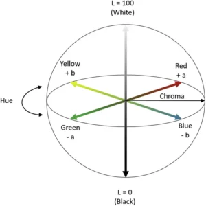
Fig. 2) model of the CIELAB color space using 3-axis
CIELAB is designed to approximate human vision and is great for perceiving small differences in color. Unlike RGB or CMYK, the colors CIELAB defines are not defined by a monitor or printer, but instead relate to the CIE standard observer. The standard observer is an averaging of the results of color matching experiments under that particular laboratory’s conditions to create a set base value for future reflectance recordings. For ocean coring, machines like the Section Half Multisensor Logger (SHMSL) use the CIELAB system for imaging cores.
The SHMSL
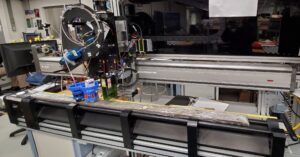
Fig 3.) photo of the Section Half Multisensor Logger on the JOIDES Resolution scanning an ocean core.
The SHMSL measures two things, spectral reflectance and magnetic susceptibility. These are used to create core descriptions. Since the SHMSL uses CIELAB, it requires a standard observer to set the “base” values. To set the standard observer, the SHMSL has a color reflectance control set (figure 4). The reflectance control set is similar to the ColorChecker used in professional photography (figure 5). These color patches have a known spectral reflectance value and are designed to mimic the values of natural objects, or in this case potential sediment and hard rock colors. The SHMSL is calibrated using this control set and a white standard. It then uses this recorded reflectance value to adjust future values.
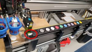
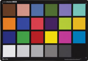
Fig. 4) A photo of the SHMSL color reflectance control set (left). Fig. 5) A photo of the Macbeth ColorChecker commonly used in photography (right).
Once calibrated and properly set up, the SHMSL is ready to read a core! Below is a finished reading of a core (figure 6). The three graphs at the bottom show the L*, a*, and b* values along the length of the core.
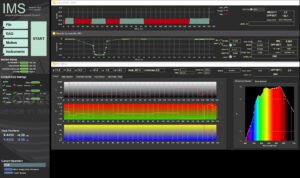
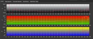
Fig. 6.1) Main IMS- SHMSL Data Acquisition Display (top). Fig 6.2) A zoomed in photo of the Main IMS- SHMSL Data Acquisition Display focusing only on the L*a*b* graph (bottom).
The numbers at the bottom of each L*, a*, and b* graphs match with the length of the core in cm. For example, at 20cm this reading shows that the core had a L* value above 80, an a* value around -30, and a b* value of around 47. This means the color was lighter in value, more green than red and more yellow than blue. A color with these values looks roughly like this (figure 7):
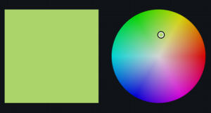
Fig. 7) A photo of a pale, yellow-greenish color.
Machines like the SHMSL are important for identifying colors on ocean cores. As we humans age, the differences in color vision grow wider due to the yellowing of our lens over time. A person in their 50s will see colors in a more yellow tint than someone in their teens due to aging. The SHMSL sets a standard for the lighting and imaging in the laboratory, narrowing the divide to provide the most accurate reading of color on the core possible.
Applying to the core
So now we know how to read the machine, but what does the color of an ocean core actually tell us? Color differences are used to quantify how an object’s color can change over time from light exposure, heat, and humidity. In the case of ocean cores, “spectral data can be used to estimate the abundances of certain compounds,” (TAMU). This means, the light values of a core may tell us about potential organic content. For example, green cores may be an indication of glauconite (depending on location and geological time) which could indicate an ancient shallow marine environment. Look back at figure one. Based on what we know of this area of the ocean floor, this type of color contrast and coloration is a clear example of a dolomotisation sequence (the formation of dolomite). Colors are powerful tools used for studying our oceans, and our oceans are full of colorful knowledge waiting for those with eyes to see it.
Sources:
- Berns, R. S. (2016). Color science and the visual arts a guide for conservators, curators, and the curious. Los Angeles Getty Conservation Institute.
- TAMU. (2026). GCR Section Half Multisensor Core Logger (SHMSL) User Guide. Atlassian.net; Texas A&M University. https://tamu-eas.atlassian.net/wiki/spaces/LMUG/pages/7341017839/SHMSL+User+Guide. Updated 06 March 2026
- Erick Bravo, Imaging Specialist for X401 aboard the JOIDES Resolution. Accessed 28 June 2026.
- Ly, Bao & Dyer, Ethan & Feig, Jessica & Chien, Anna & Bino, Sandra. (2020). Research Techniques Made Simple: Cutaneous Colorimetry: A Reliable Technique for Objective Skin Color Measurement. The Journal of investigative dermatology. 140. 3-12.e1. 10.1016/j.jid.2019.11.003.
- Macbeth ColorChecker. (2026). Imatest.com. https://www.imatest.com/wp-content/uploads/2022/01/msccc_colorchecker_classic_front.jpg
- Banaś, W. (2024). Convert LAB to RGB – colordesigner.io. Colordesigner.io. https://colordesigner.io/convert/labtorgb
Image sources:
Figure 1: Source 3
Figure 2: Source 4
Figure 3-4,6: Source 2
Figure 5: Source 5
Figure 7: Source 6
Written by OCA 2026 Mentor, Kellan Moss
By Naomi Krauzig (GEOMAR)
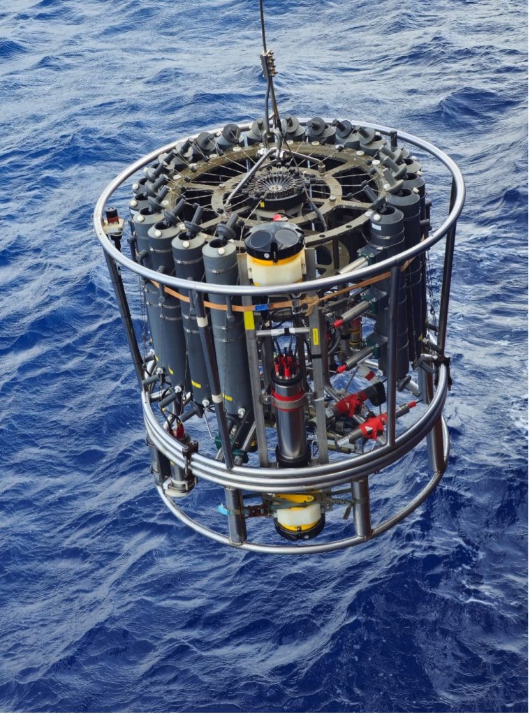
As the research vessel METEOR heads north toward Germany, the CTD Lab has become quiet.
For the past four weeks, the CTD rosette (named after the three core variables it measures: conductivity, temperature, and depth) has been one of the busiest instruments on board. Day and night, it disappeared beneath the waves and returned with information about the entire water column.
Now the final station has been completed and the CTD rosette has been stored away for the last time. It feels like the right moment to reflect on a tool that has accompanied generations of oceanographers -and on a ship that has done the same.
Introduced in the 1970s, Conductivity-Temperature-Depth (CTD) systems revolutionized ocean observation by providing continuous measurements throughout the water column. When METEOR III entered service in 1986, the CTD was already the workhorse of physical oceanography. In the 1990s, it gained a trusted companion: the Lowered Acoustic Doppler Current Profiler (LADCP), capable of measuring ocean currents from the surface to the seafloor.
Aboard METEOR, the CTD rosette now also carries a suite of additional sensors measuring oxygen, chlorophyll, turbidity, photosynthetically active radiation, nitrate, and even particles and plankton through an Underwater Vision Profiler. At the same time, its Niskin bottles collect seawater samples for analyses of oxygen, nutrients, salinity, and other properties, providing a detailed picture of the water column.
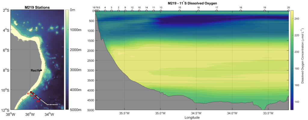
During M219, this classic CTD/LADCP system helped us reveal some of the hidden “highways” of the tropical Atlantic. Along the 11°S section off Brazil, a key location for monitoring the Atlantic Meridional Overturning Circulation, CTD measurements identified distinct water masses through their temperature, salinity, and oxygen signatures. At the same time, the LADCPs captured the currents carrying them: the warm, northward-flowing North Brazil Undercurrent in the upper ocean and the colder, southward-flowing Deep Western Boundary Current nearly two kilometers below.
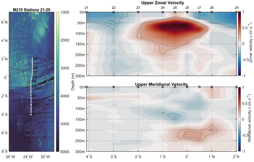
Further north, along 23°W, we crossed the equator and encountered one of the strongest subsurface currents in the world ocean: the Equatorial Undercurrent. Hidden just beneath the surface, this powerful eastward-flowing jet transports enormous amounts of water, heat, oxygen, nutrients, and carbon across the Atlantic: roughly one hundred times the discharge of the Amazon River!
While these observations allow us to investigate water masses, currents, and the circulation of the tropical Atlantic, they also carried an additional meaning for many on board.
For four decades, CTD rosettes have been lowered from the deck of METEOR III in every ocean of the world, helping scientists understand complex ocean processes, monitor changes, and train generations of oceanographers. During more than 11,940 days at sea, thousands of stations have been completed from her deck. Countless students, technicians, crew members, and scientists have contributed to these observations, and many have built their careers around the data collected aboard this vessel.
To take part in the final cruise -and the final CTD cast- of METEOR III was a privilege. Over the course of this voyage, it became impossible not to notice the connection many people have with this vessel. For some, METEOR has been a second home for years. Colleagues became lifelong friends, sometimes even family, and countless memories were made during deployments, watches, and transits at sea. The research vessel, the discoveries, and even the familiar CTD rosette hold a special place in many hearts.
As we pack the last equipment and the laboratories become emptier, it is difficult not to wonder what comes next. METEOR IV will soon continue the tradition, equipped with new capabilities and ready to tackle the scientific questions of the coming decades. New technologies will undoubtedly expand how we observe the ocean, yet some traditions are likely to endure.
https://www.oceanblogs.org/m219/2026/06/27/no-cruise-without-a-ctd/
By Joelle Habib (Laboratoire d’Océanographie Villefranche)
When I was a kid, I wanted to be a photographer. I still do, actually. But somewhere along the way, science intervened, and it gave me something I never expected: the chance to be an underwater photographer. Not the National Geographic kind who chases polar bears or waits weeks for a penguin to do something interesting. My subjects are smaller. Much, much smaller. I get to photograph the invisible life of the deep ocean, the tiny animals and sinking particles that most people never know exist. And the camera I use to do it descends to 6000 meters below the surface.
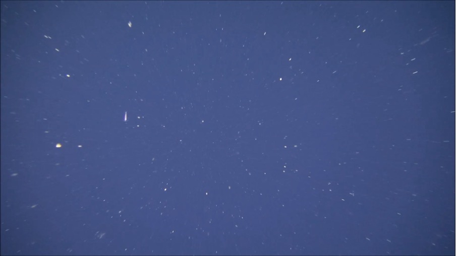
This instrument is called the UVP, or Underwater Vision Profiler. On this cruise, we deployed a UVP6 attached to the CTD rosette, profiling down to 4000 meters depth. The instrument activates automatically once its pressure sensor detects it is moving downward, takes up to 20 pictures per second all the way to the bottom of the cast. But before we talk about what the UVP gives us and why it matters, we need to talk about what it actually photographs: zooplankton and particles.
If you have ever watched SpongeBob SquarePants, you already know a zooplankton. Sheldon J. Plankton, the tiny villain who is perpetually trying to steal the Krabby Patty formula, is one. And funnily enough, the most abundant zooplankton across all the world’s oceans, is indeed this small crustacean: the copepod.
Here is the basic idea: a plankton is any organism that drifts with the ocean currents rather than swimming against them. If it photosynthesizes like a plant and contains chlorophyll pigments, it is a phytoplankton. If it is an animal, it is a zooplankton. A jellyfish is a zooplankton, just a very large one. Zooplankton graze on phytoplankton, on each other, and on anything small enough to eat. Now for the process that connects all of this to climate, to carbon, and to why we are out here on a research vessel in the middle of the equatorial Atlantic: the biological pump.
The biological pump is the ocean’s mechanism for pulling carbon out of the atmosphere and locking it away in the deep sea. Here is how it works: phytoplankton at the surface absorb CO₂ from the atmosphere and convert it into organic matter through photosynthesis. When they die, or when zooplankton eat them, defecate, excrete, and die themselves, all of that organic carbon does not simply disappear. It becomes marine snow! Yes, it snows in the ocean!!! Marine snow consists of a continuous rain of particles, aggregates, fecal pellets, shed exoskeletons, … Every flake of marine snow is a fragment of life that once existed at the surface, now on a one-way journey into the deep. This is the gravitational pump, one of the most important carbon sinks on Earth, and it is one of the pumps that the UVP was built to observe.
Marine snow seen by PELAGIOS (Pelagic In situ Observation System) in the Tropical Atlantic; 23°W; 100 m depth. Photo Credit: Henk-Jan Hoving
So why image and count particles rather than simply collecting water samples or relying on sediment traps? Because the abundance and size distribution of marine particles are two of the major factors controlling biological carbon sequestration in the ocean, and traditional methods cannot capture them at high resolution throughout the water column. Vertical profiles of particle images can reveal the processes that determine particle size, type, and distribution, and combined with information on carbon content and sinking velocity, they provide high-resolution information on how the biological pump operates at depth. The UVP allows for the remote collection of large datasets on particle abundances and their size distributions, enabling much higher spatial and temporal resolution than traditional methods. But particles are only one part of the story, the UVP also tracks zooplankton and their daily migrations: every night, zooplankton rise from the deep to feed near the surface, then sink back down before dawn, actively carrying carbon into the deep ocean in their own bodies. Without imaging tools like the UVP, this active carbon flux is nearly impossible to quantify.
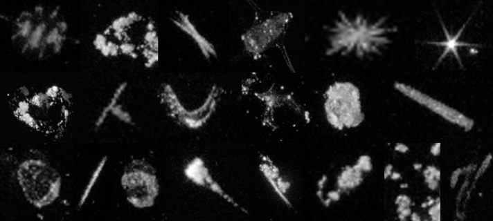
Each image you see here was taken in complete darkness, somewhere between the ocean surface and 4000 meters below. The UVP6 illuminates a tiny volume of water, with a single red flashing light, capturing only the particles and organisms that happen to drift through that small window at that exact moment.
The instrument captures everything larger than 100 micrometers, roughly the width of a human hair. In the images you will see two types of things: fuzzy, irregular blobs of varying sizes: Marine snow aggregates. And more defined, structured shapes, sometimes with appendages, antennae, or transparent shells. Those are the zooplankton.
Every image is a small portrait of a world that already existed long before we had the tools to see it. I am so lucky I am able to see parts of that hidden life in this lifetime.


-
Climate Change11 months ago
Guest post: Why China is still building new coal – and when it might stop
-
Greenhouse Gases11 months ago
Guest post: Why China is still building new coal – and when it might stop
-

 Greenhouse Gases2 years ago
嘉宾来稿:满足中国增长的用电需求 光伏加储能“比新建煤电更实惠”
-

 Climate Change2 years ago
嘉宾来稿:满足中国增长的用电需求 光伏加储能“比新建煤电更实惠”
-

 Renewable Energy8 months ago
Sending Progressive Philanthropist George Soros to Prison?
-
Climate Change2 years ago
Bill Discounting Climate Change in Florida’s Energy Policy Awaits DeSantis’ Approval
-

 Carbon Footprint2 years ago
US SEC’s Climate Disclosure Rules Spur Renewed Interest in Carbon Credits
-
Greenhouse Gases12 months ago
嘉宾来稿:探究火山喷发如何影响气候预测