

Neighbourhoods in England that are home to the most minority-ethnic people are 15 times more likely to face extreme heat than the least diverse areas, according to Carbon Brief analysis.
People with the lowest carbon footprints – who therefore contribute less to climate change – are also more likely to live in areas that experience high temperatures.
This is based on Carbon Brief analysis that combines satellite data on heat exposure with data on per-capita emissions, ethnicity and levels of deprivation across England.
Thousands of deaths in the UK have been attributed to heat in recent years and the threat is expected to grow as climate change worsens.
But heat is also felt differently across the country, with certain groups both more exposed and more vulnerable to dangerous temperatures.
Broadly, the analysis shows how those subject to the “urban heat island” effect in English cities, often in low-quality housing and with little access to green space, are more likely to experience extreme heat.
Experts tell Carbon Brief that policymaking should reflect the reality of climate change “amplifying” inequalities across society and provide help to those most in need, such as more heat-resilient social housing.
Heat threat
As greenhouse gas emissions and global temperatures rise, more people in the UK are likely to become ill or even die due to extreme heat.
Heat has killed around 6,000 people in England over the past three years, according to government figures. This is roughly double the number killed over the same period between 2016 and 2018.
Scientists have repeatedly linked extreme heat – and the resulting deaths – to climate change.
In June 2025 alone, more than 260 people died in London due to a heatwave, according to a recent attribution study that linked the event to climate change.
Government advisor the Climate Change Committee (CCC) estimates that the number of heat-related fatalities in the UK each year is set to triple by 2050, without adaptation measures.
Around half of homes in the country are already at risk of overheating and the CCC expects this to reach 90%, if global temperatures rise by 2C above pre-industrial levels.
However, these risks will not fall equally across society, with children, the elderly and disabled people more vulnerable to heat-related illness. There is also evidence that poorer communities and people of colour are more vulnerable to extreme heat.
Such communities also tend to have lower carbon footprints than those that are whiter and wealthier.
This fits with the broader concept of climate justice, which describes how people who are least responsible for climate change often end up bearing the brunt of its effects.
Carbon footprints
To investigate these issues, Carbon Brief combined detailed satellite data on heat exposure across England, provided by 4 Earth Intelligence, with neighbourhood-level carbon footprints compiled by the Centre for Research in Energy Demand Solutions (CREDS).
The CREDS dataset provides estimates of per-person carbon footprints, indicating how much the average person in each neighbourhood is contributing to climate change.
Due to data availability, this analysis focuses exclusively on England, the nation that experiences the most extreme heat in the UK.
Every neighbourhood is scored based on its “heat hazard”, meaning the likelihood that it will experience higher relative temperatures during hot weather, compared to surrounding areas.
The analysis then zooms in on the 10% worst-affected neighbourhoods in England. These neighbourhoods have a heat hazard score of 4 or 5, meaning that they face higher exposure to heat than 90% of areas around the country. (For a full explanation, see Methodology.)
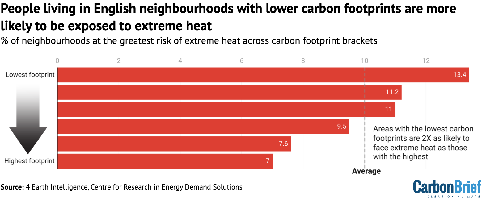
The figure below shows that neighbourhoods with lower carbon footprints are twice as likely to face high heat hazard scores than areas with higher carbon footprints.
Specifically, it shows that 13.4% of neighbourhoods with the lowest carbon footprints are among the English areas most exposed to heat hazards. In contrast, only 7.0% of neighbourhoods with the highest carbon footprint are among the most heat-exposed areas.
Neighbourhoods in England with lower carbon footprints are often in dense, urban areas, where people tend to be less reliant on cars and more likely to live in energy-efficient flats.
Areas with higher carbon footprints are commonly found in rural areas, where travelling by car can be a necessity due to limited public transport.
Also, particularly in south-east England, people in these rural neighbourhoods are often wealthier, meaning they spend more money on flights and other high-emitting luxuries.
Ethnicity and deprivation
Carbon Brief also analysed the heat threat facing deprived neighbourhoods in England and those that are home to more people of colour.
Information about how many people identify as black, Asian and other minority ethnicities in each neighbourhood is based on 2021 census data, via the Office for National Statistics.
As the chart below shows, there is a clear correlation between the number of people of colour living in a neighbourhood and the likelihood of it facing extreme heat during periods of hot weather.
The most ethnically diverse neighbourhoods – where roughly half or more of the population are people of colour – are 15 times more likely to have high heat hazard scores than the least ethnically diverse neighbourhoods, where almost everyone is white.

Among the most diverse areas are parts of Newham in east London, Saltley in Birmingham and Spinney Hills in Leicester, all of which are inner-city areas.
The least diverse neighbourhoods range from coastal parts of Redcar and Cleveland in North Yorkshire to the rural villages of south Somerset. None of England’s hottest 1% of neighbourhoods are in this bracket.
Additionally, Carbon Brief assessed the relationship between levels of poverty and heat risk, based on England’s indices of deprivation dataset. This covers several measures of deprivation, including income, employment and health.
People living in the most deprived English neighbourhoods are more than three times as likely to face high levels of heat hazard as those in the least deprived neighbourhoods, as shown in the figure below.
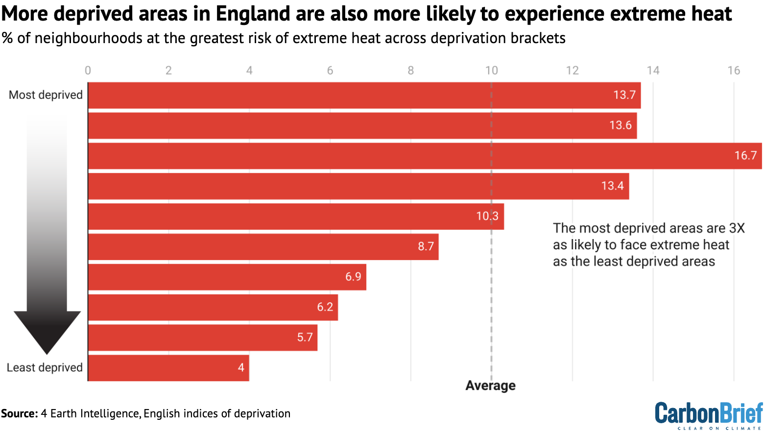
The correlation between poverty and extreme heat is less extreme than the one between heat exposure and ethnicity.
While many of England’s most deprived areas are in cities, they are also clustered in some rural and coastal areas – such as parts of Cornwall and Lincolnshire – which tend to be cooler.
Urban heat island
The key phenomenon captured by this analysis is the urban heat island effect. This describes how cities – and particularly areas with dense buildings, roads and stretches of concrete that absorb heat – tend to be hotter than the surrounding countryside.
Cities such as London, Manchester and Birmingham have reached temperatures up to 5C hotter than the surrounding areas in recent decades, due to this effect.
The diagram below shows how air flows circulate between rural and urban areas, forming “heat domes” over cities.
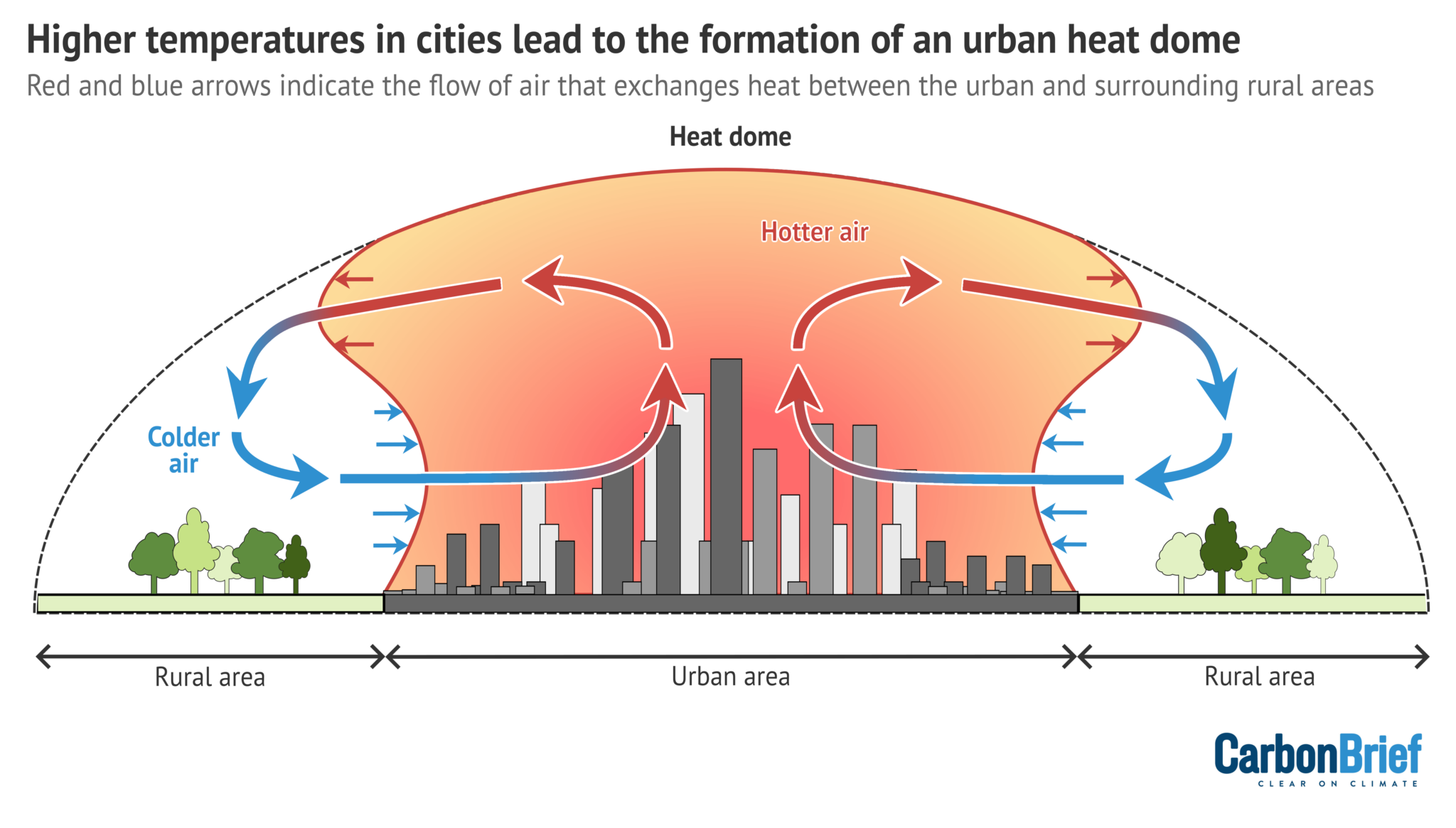
Inner-city areas in England are also home to many people facing high levels of deprivation, as well as large black and Asian communities. Many of these communities are therefore exposed to more dangerous temperatures due to the urban heat island effect.
Access to green spaces, even within cities, also influences exposure to the urban heat island effect. Research has shown how people in deprived areas and people of colour – particularly black people – are more likely to live in areas with less access to green spaces.
There is already extensive scientific literature that uses satellite data to demonstrate the urban heat island effect in cities and other locations.
A number of studies have also used this data to show how people of colour and those living in poverty are more exposed to extreme heat. Much of this research has come from the US, where historic housing inequalities have created stark patterns of segregation in many cities.
A project led by environmental policy researcher Dr Angel Hsu of the University of North Carolina-Chapel Hill shows how, globally, “cities are burdening lower-income populations with higher heat exposure”, as she tells Carbon Brief.
Given this, Hsu adds that “it’s not surprising to us to see similar disproportionate exposure patterns among UK neighbourhoods”.
Other researchers tell Carbon Brief that it is important to be wary of satellite data, as it does not precisely capture the air temperatures experienced in these neighbourhoods.
Dr Charles Simpson, who researches the health and economic impacts of climate change at University College London (UCL), notes:
“Satellite-measured surface temperature does not always correlate with the air temperature – what you are measuring includes a lot of road surfaces and rooftops. The air temperature is thought to be more directly relevant to people’s health and their cooling needs.”
Previous research has found that satellite data can therefore overestimate the urban heat island effect compared to data from weather stations.
These stations, however, are not widespread enough to allow comparisons with detailed neighbourhood data. They are particularly lacking in more deprived areas in England, potentially making measurements there less reliable.
Other scientists tell Carbon Brief that, in the absence of a comprehensive ground monitoring network, satellite measurements can serve as a stand-in to estimate heat exposure. Dr Chloe Brimicombe, an extreme-heat researcher based at the University of Graz, explains:
“Although it’s not a good indicator of perceived [temperature], it is a good indicator of what regions are most built up and have the environments that are most vulnerable to heat.”
‘Amplifying’ inequalities
There is a growing body of evidence gathered by activists, scientists and local governments around the UK revealing the unequal burden of climate change.
Dr Charles Ogunbode, an assistant professor of applied psychology at the University of Nottingham who specialises in how people experience climate change, tells Carbon Brief that this kind of data helps to clarify the links between climate change and inequalities:
“We can’t avoid dealing with the issue of social inequalities and climate change is just basically amplifying those things. It’s highlighting them, it’s revealing them. So whatever policies we put in place – be it in the health sector, be it in the climate sector – addressing those inequalities has to be an essential part of whatever those responses are.”
There are many factors influencing how people experience heat that are not captured in Carbon Brief’s analysis.
Previous work by researchers at the University of Manchester and Friends of the Earth has explored this issue, including an analysis of more than 40 indicators that could make neighbourhoods more “socially vulnerable” to heat.
This reveals similar outcomes, with people of colour and those contributing the least to climate change generally more vulnerable to its impacts.
One of the biggest factors that contributes to people’s exposure to heat extremes in the UK is the country’s housing stock, which is “not fit for the future”, according to the CCC.
UK homes have generally not been built for hotter conditions and poorer people are more likely to live in badly adapted housing. Those living in small homes, flats and social housing in England all “suffer significantly more overheating” during heatwaves, according to one study.
Dr Giorgos Petrou, a researcher in building physics modelling at UCL, tells Carbon Brief that it is also vital to consider whether households have the ability to adapt to climate change. “Amongst other factors, their capability will depend on their financial means and whether they own or rent their home,” he says.
Experts tell Carbon Brief that the government should act across its policy agenda to not only address extreme heat, but also support those who are most affected by it. This could involve expanding tree cover and renovating old social housing stock in at-risk communities.
Emma Howard Boyd, a former chair of the Environment Agency who also chaired the London Climate Resilience Review, tells Carbon Brief:
“I do think that with [the Labour] government focusing on house building and retrofit, this is a fantastic opportunity to get this right…For those communities that have had the least impact on the environment and climate change themselves.”
Methodology
This analysis collates several datasets that cover England at a neighbourhood level, with “neighbourhoods” defined as lower-layer super output areas (LSOAs). These are small statistical areas used by the UK government, covering populations of about 1,500-3,000 people. There are 33,755 LSOAs in England.
Data on vulnerability to heat comes from 4 Earth Intelligence (4EI), which analyses land surface temperature to generate “heat hazard” information at a 30m resolution. This detailed information has been converted into LSOAs by 4EI.
Heat hazard scores are calculated by 4EI, based on the likelihood that a given neighbourhood will experience high temperatures during hot weather, relative to the surrounding area.
Each score corresponds to a different percentile of English neighbourhoods. The bar below shows the percentage breakdown across all LSOAs in England.
The two hottest scores – those coloured in red – correspond to the 10% of English neighbourhoods that have higher heat hazard scores than the remaining 90%.

For simplicity, Carbon Brief’s analysis focuses on the red bars above, meaning neighbourhoods in either the top 90th-99th percentile or 99th percentile of heat hazard. (Neighbourhoods in the 90th-99th percentile have higher heat hazard scores than 90% of areas in England. Neighbourhoods in the 99th percentile have higher heat hazard scores than 99% of areas.)
It shows how these two scores are overrepresented in LSOAs that have lower carbon footprints, more diverse communities and higher levels of deprivation.
Carbon-footprint data is from the CREDS “place-based carbon calculator”, which estimates the average per-person carbon footprint for every LSOA in England. It accounts for emissions-producing activities ranging from electricity use to “consumption of goods and services”.
CREDS assigns the grades “A” to “F” (low carbon footprint to high carbon footprint) to neighbourhoods. Carbon Brief has based its carbon-footprint analysis on these grades.
LSOA-level data on black, Asian and other minority-ethnic populations comes from 2021 census data. English LSOAs were broken down into deciles, based on the percentage of the population that identified as non-white ethnicities.
The lowest decile covered the tenth of LSOAs with between 0 and 2% non-white minority-ethnic populations and the highest covered the tenth with more than 51%.
England’s indices of multiple deprivation dataset also includes LSOA-level information. It provides relative measures of deprivation for LSOAs in England, based on income, employment, education, health, crime, living environment and barriers to housing and services. Carbon Brief broke the LSOAs down into deciles based on the total deprivation scores, from the most deprived to the least deprived.



The post Analysis: England’s most ethnically diverse areas are 15 times more likely to face extreme heat appeared first on Carbon Brief.
Analysis: England’s most ethnically diverse areas are 15 times more likely to face extreme heat

Israel’s bombardment of Gaza during the conflict that broke out in October 2023 has wrecked progress towards adapting the enclave to climate change and left two million Gazans vulnerable to heatwaves, drought and disease, the Palestinian Authority (PA) said in a new climate plan submitted to the United Nations.
Palestine’s third nationally determined contribution (NDC), uploaded to the UN climate body’s website this week, says that while “the aggression on the Gaza Strip did not make the climate worse”, “it removed the housing, water and sanitation systems, health facilities, energy networks, roads and livelihoods through which people absorb a climate they were already struggling with.”
The 91-page document lists the types of infrastructure it says Israel has destroyed and notes how the destruction will worsen the impacts of climate change. It says the bombing of hospitals and rising hunger have make it harder for Gazans to cope with the health impacts of climate-driven heatwaves and waterborne diseases.
The destruction of water tanks, boreholes and desalination plants, meanwhile, have left Gazans struggling with the effects of water shortages and drought, while mass unemployment reduces people’s ability to afford climate-driven price rises. The erasure of most of the Strip’s homes makes it more difficult for people to avoid the sun’s increasing heat, the NDC said.
Many Gazans are now living in the ruins of collapsed buildings or in makeshift shelters and tents that offer little or no protection from high temperatures.
Palestine’s previous goals to cut emissions and adapt to climate change in Gaza, expressed in its last NDC five years ago, were based on a pre-war baseline that “no longer describes anything that exists”, the NDC says. Progress made since 2021 has now been destroyed, it adds.
Green reconstruction of Gaza
Instead of continuing to aim for these adaptation and emissions-reduction goals, the PA is now calling for the green reconstruction of Gaza. It says buildings should be constructed again in an energy-efficient manner with solar panels and served with modern water, waste and transport systems.
While the PA, controlled by the Fatah political party, continues to claim legitimate control of Gaza, the strip was effectively governed by Fatah’s rival Hamas between 2007 and the recent war. Control is now split between Israel and the political wing of Islamist militant group Hamas, after a US-backed ceasefire took effect in October 2025, although a UN-backed committee plans to take over.
-
Germany uses funding to pressure climate groups on Israel-Gaza war
Many Global South climate groups are funded by the German government, a political ally of Israel, and feel unable to criticise Israel’s military action in Gaza -
Loss and damage fund urged to hold crisis meeting on Nepal
The new fund is coming under pressure from developing nations to respond quickly to climate disasters rather than just financing longer-term projects -
More support needed to power Africa’s food systems with renewables, experts say
Renewable energy could help African food businesses boost productivity and competitiveness, but the upfront cost, fragmented markets and limited financing stand in the way

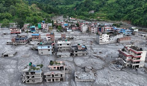

The United Nations, European Union and World Bank have jointly estimated that Gaza needs $71.4 billion of investment in the next two years to recover and build back. This process should be Palestinian-led, they said in April.
But US President Donald Trump has said the US should “take over” and “own” Gaza and redevelop it as the “Riviera of the Middle East”. Israel’s right-wing prime minister Benjamin Netanyahu has said that Israel should control the territory with civil administration managed by Palestinians favourable to Israel.
With occupation, targets conditional
In the other part of Palestine, the West Bank, the Palestinian Authority carries out some government functions, but ultimate control rests with Israel, which has occupied the West Bank since 1967.
Because Israel controls planning in most of the West Bank, the NDC argues that the PA cannot pursue all the climate projects it wants. In addition, Israel restricts the movement of PA officials, making data collection difficult, and controls the West Bank’s electricity supply meaning that the PA cannot control whether it comes from dirty or clean sources of energy.
Given this situation, the NDC says that all of Palestine’s new climate targets are conditional but it will aim to reduce emissions 12.8% below a business-as-usual baseline by 2035 and 17.1% by 2040. If the Israeli occupation ends and Palestine regains full sovereignty over its land and resources, it will aim for reductions of 15.1% and 19.1% by 2035 and 2040 respectively under an “independence pathway”.
That could allow, for example, for greater electrification and reducing emissions per unit of growth, the document said.
To achieve the 2035 emissions-reduction target and adapt to the impacts of climate change, the PA says it needs $8.6 billion in total. This funding would be spent on measures like encouraging solar farms and rooftop solar and scaling up solar water heating to cover four-fifths of households. To complement the planned increase in solar power, the authority wants to modernise the electricity grid and install battery storage.
In the transport sector, it aims to promote the uptake of electric vehicles, develop bus rapid transit corridors and scrap old polluting trucks and buses. In Gaza in particular, it wants to deploy 66 electric buses when the conflict ends.

To adapt to climate-driven drought, the NDC includes initiatives to reuse wastewater through treatment plants, build desalination plants in Gaza to remove salt from seawater, and promote irrigation for farmers.
The new climate plan was prepared by Palestine’s Environment Quality Authority, with support from the United Nations Development Programme and the governments of Britain and Spain.
The United Nations recognised Palestine’s statehood in 2012 and it joined the UN’s climate convention and signed the Paris climate agreement – which requires countries to submit more ambitious NDCs every five years – in 2016.
The Israeli foreign ministry did not respond to a request for comment. But in late 2024, then Israeli climate envoy Gideon Behar told Climate Home News that the war and the resulting environmental destruction in Gaza was the fault of Hamas.
The post Palestine: Israel’s bombing has left Gaza vulnerable to climate change appeared first on Climate Home News.
Palestine: Israel’s bombing has left Gaza vulnerable to climate change
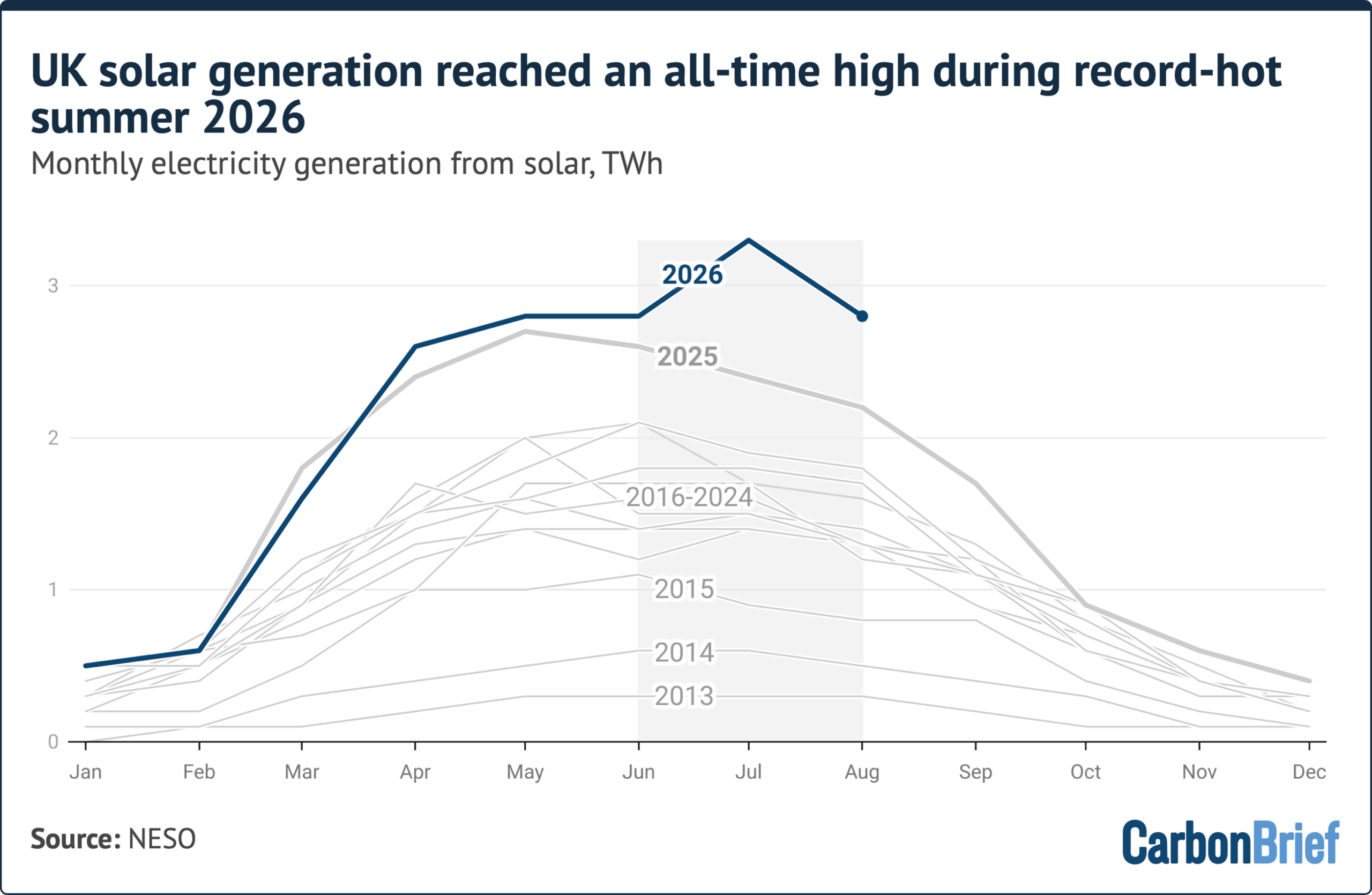
Solar power generation in the UK reached a new record over the summer of 2026, as temperatures across the nation soared, according to new analysis by Carbon Brief.
Collectively over June, July and August, solar farms and rooftops generated 8.8 terawatt-hours (TWh) of electricity in the UK*, as shown in the chart below.
Speaking to Carbon Brief, Chris Hewett, chief executive of trade association Solar Energy UK welcomed the new record, adding that it was driven by “clear skies and continued growth in deployment”.
This surge in generation took place amid the hottest summer on record in the UK, with five heatwaves between May and August.
Summer 2026 was the sixth sunniest on record, with more than 620 hours of sunshine, according to the Met Office. England and Wales – which experienced the most extreme heat – saw their second-sunniest summers on record.
June 2026 was the hottest June in England since records began in 1884, according to Met Office data, while Wales and the UK as a whole experienced their second-warmest June.
It was the driest July for England and Wales since records began in 1836, with some parts of London seeing no rain at all in the month, while Wisley in Surrey had no rain for 62 days.
In England, temperatures peaked at 38.1C at Kew Gardens in London on 13 August.
According to the Met Office, this summer’s record mean temperature was made 130 times more likely by climate change.
Amid these hot and sunny months, solar power generation increased 23% from the same period in 2025. This is double the level of solar generation over the summer of 2021, according to Carbon Brief analysis.
While solar panels can be affected by periods of extreme heat, the longer hours of daylight and higher levels of irradiation over the summer more than offset any efficiency losses.
June, July and August all saw solar set new monthly records for solar generation – July saw the highest solar generation in a calendar month ever, with 3.3TWh meeting 15% of overall electricity demand for the month.
As of the end of August, the total UK solar generation in 2026 stood at 17TWh – 13% higher than the same point in 2025.
The number of solar farms and rooftop installations has grown substantially in recent years, helping to boost generation. Domestic rooftop solar accounts for around 29% of total capacity.
In 2025, the UK’s solar capacity reached 21 gigawatts (GW) by the third quarter of the year, according to UK government figures. This is a jump of 3GW, or 18%, year-on-year, as Carbon Brief reported in January.
(Capacity is the maximum output possible from an electricity generation, whereas generation is what was produced over a certain time period, such as a day, month or year.)
According to the University of Sheffield, the installed solar capacity is now nearly 24GW.
This includes nearly 172,000 solar installations that have been fitted across the UK since the start of 2026, according to recent government figures. In July alone, more than 19,800 rooftop solar panels were installed – the equivalent of one installation every two minutes.
In total, nearly 1.7m households in the UK now have solar panels installed.
Over 26 heatwave days this summer – periods of at least three days when temperatures exceed the Met Office’s county-level heatwave temperature threshold – UK households with rooftop solar panels avoided an estimated £86.7m in electricity costs, according to analysis by Utility Bidder.
Talking about the surge in solar generation this summer, Hewett says:
“[It] not only kept bills down for people with solar and batteries in their homes, but helped keep overall power prices much lower than they would have been if Britain had been relying on more gas generation during the day”.
Despite the record generation, no new half-hourly solar power output record was set in the summer of 2026. This still stands at 15.2 megawatts (MW) on 23 April 2026.
* This article refers to the UK throughout, but strictly relates to the island of Great Britain, made up of England, Scotland and Wales. Northern Ireland is part of the separate, all-Ireland electricity system.
related
Factcheck: 10 flaws in the Conservative report on ‘cheap power’
Q&A: What is ‘long-duration energy storage’ – and why does the UK need it?
Q&A: What does China’s 15th ‘five-year plan’ for renewables mean for climate change?
Analysis: Wind and solar power overtake fossil fuels in Germany for first time ever
The post Analysis: UK solar power hits record high over summer 2026 appeared first on Carbon Brief.
Farmers around Europe are dealing with the aftermath of a summer of extreme heat, drought and wildfires that were exacerbated by climate change.
Human-caused climate change is increasing the severity and likelihood of many extreme weather events around the world, which is increasing volatility for food producers.
This summer resulted in, for example, shrunken potatoes in the Netherlands, reduced carrot harvests in France, dried-up rice fields in Italy and scorched olive groves in parts of the Mediterranean region.
Global food prices are currently at their highest level since early 2023 due to “heatwaves and energy price dynamics”, according to the UN Food and Agriculture Organization.
Other factors such as blocked fertiliser supplies in the Strait of Hormuz and high fuel costs have also played a role in this year’s agricultural outputs.
In the six charts below, Carbon Brief provides a snapshot of the impact this summer’s extremes are considered to have had on crop production and yields across Europe.
1. Most EU countries expect to see declines in cereal production this year
2. Most countries are recording reduced crop yields
3. Around €2bn worth of cereal losses after June heatwave
4. UK yields of wheat, barley and oats are all due to drop in 2026
5. Maize production in France is due to hit a four-decade low
1. Most EU countries expect to see declines in cereal production this year
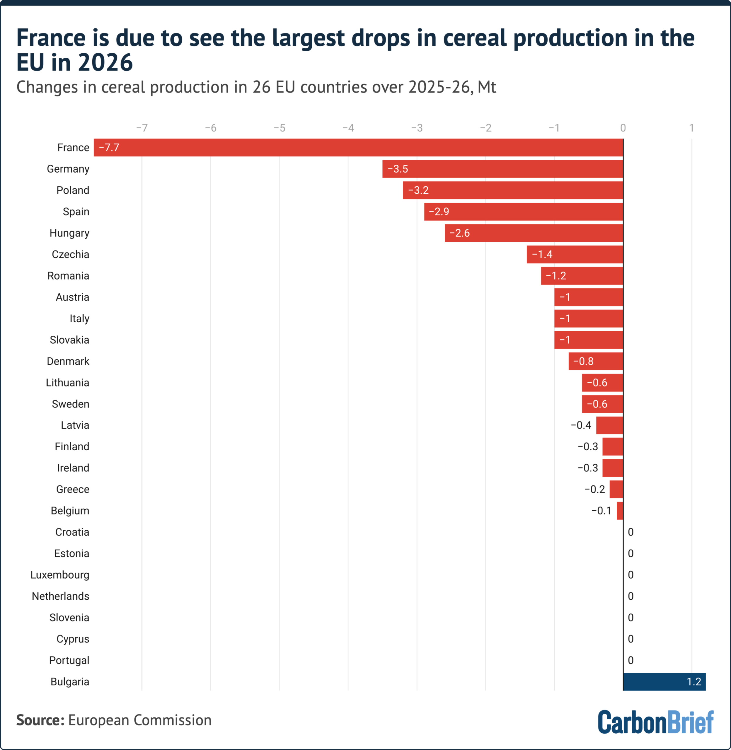
France, in particular, will see heavy losses in the amount of cereals – such as wheat, barley and oats – it produces this year, according to European Commission data.
French cereal production is expected to drop by almost 8 megatonnes (Mt) in 2026, compared to 2025.
The chart above shows that most European countries, aside from Bulgaria, will also see production losses this year.
Germany is due to see the second-largest losses in production, dropping by almost 4Mt compared to 2025.
Prof Til Feike, a cropping systems expert at the Julius Kühn-Institut, says many areas in Germany and Austria, as with other parts of Europe, have been “hit hard by a long-lasting dry period in combination with record-high heatwaves”.
This has resulted in dry grassland for animals and lower yields of maize, which is a “key fodder crop” for livestock. He tells Carbon Brief:
“In the long run, farming must adapt better to more extreme weather conditions, not only heat and drought, but also prolonged wet periods. So, there is no one-fits-all solution for climate change adaptation.”
2. Most countries are recording reduced crop yields
Heat and a lack of water have “substantially worsened” crop expectations this summer in western and most of central Europe, according to a recent bulletin from the EU Joint Research Centre.
Yields are expected to be “significantly reduced”, with local crop failures “likely” in areas such as France, southern Germany, northern and central Italy, and Hungary, it added.
The chart below shows that yields of cereal grains – which, here, refers to the tonnes of a grain grown per hectare of land – are expected to fall in most EU countries in 2026.
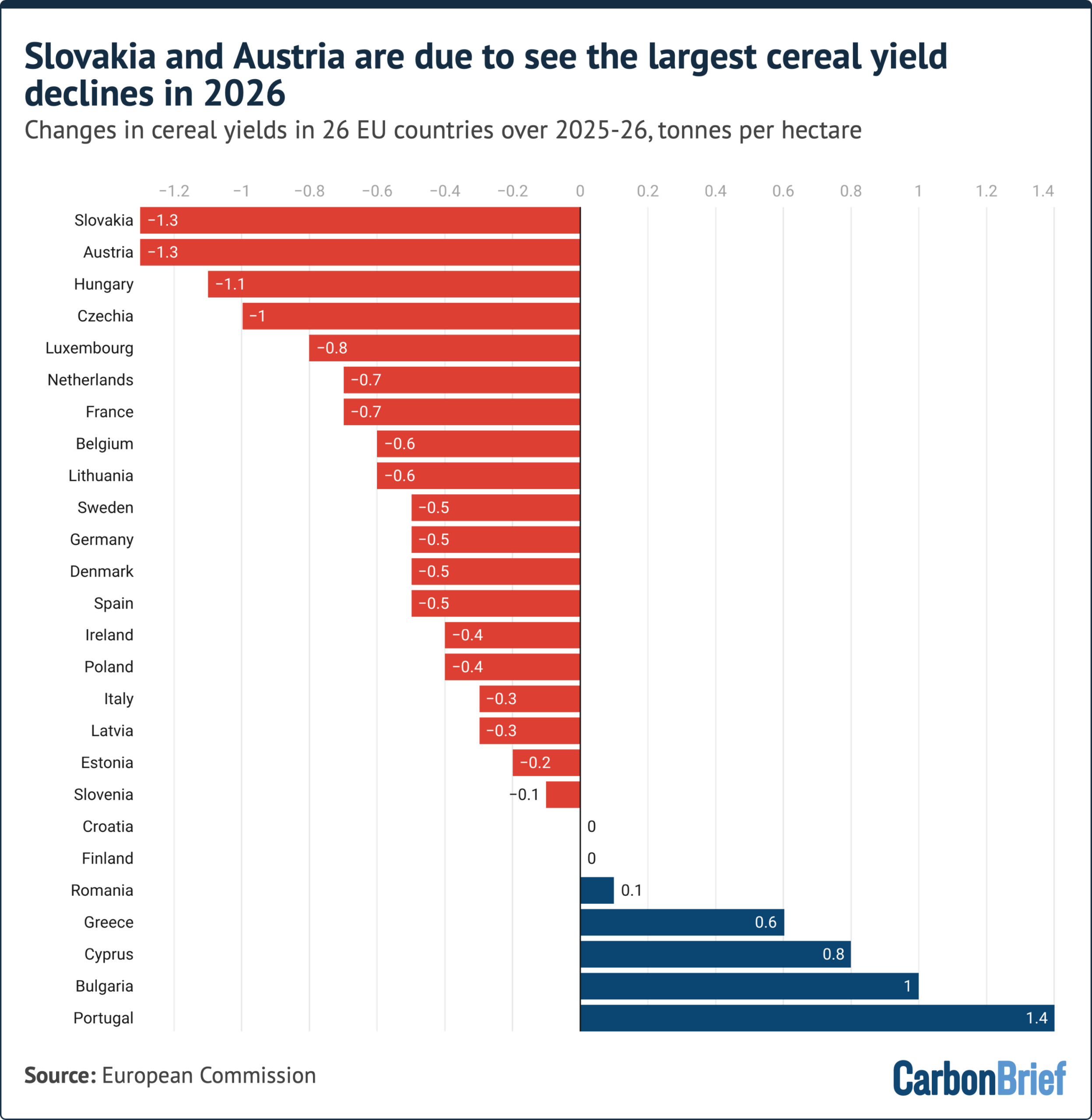
Slovakia, Austria and Hungary are expected to see the largest declines in cereal yields, reducing by more than one tonne per hectare in 2026 compared to 2025.
The recent EU bulletin noted that irrigated crops performed well in Portugal this summer – the country with the largest yield increases. Other crops relying on rainfall showed growing signs of heat stress, it added.
3. Around €2bn worth of cereal losses after June heatwave
The record heatwave that hit many parts of Europe in June contributed to an estimated €2-2.3bn in cumulative grain production losses, as shown in the chart below.
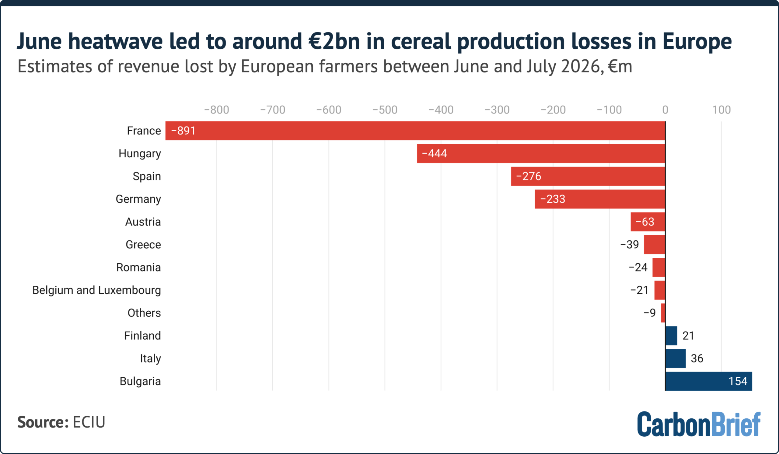
The intense June heat in western Europe would have been “virtually impossible” just 50 years ago, according to a rapid climate attribution study. It was the region’s hottest June on record.
The Energy & Climate Intelligence Unit (ECIU) thinktank analysed June and July 2026 grain forecasts from Coceral, a European grain traders association.
ECIU estimated lost supply by multiplying the change in tonnes of grains between these two months by prices for harvest delivery in 28 European countries.
Major grain producers France, Germany, Hungary and Spain accounted for 86% of the lost revenue, according to the ECIU.
Extreme heat is also expected to have a wider economic impact across the continent. Analysis from Triodos Bank found that this summer’s extreme weather could reduce the EU’s gross domestic product (GDP) by around 1% this year, or around €180bn.
4. UK yields of wheat, barley and oats are all due to drop in 2026
If current trends continue, the average yields for cereals and oilseeds will result in the UK’s worst harvest since detailed records began in 1984, according to ECIU.
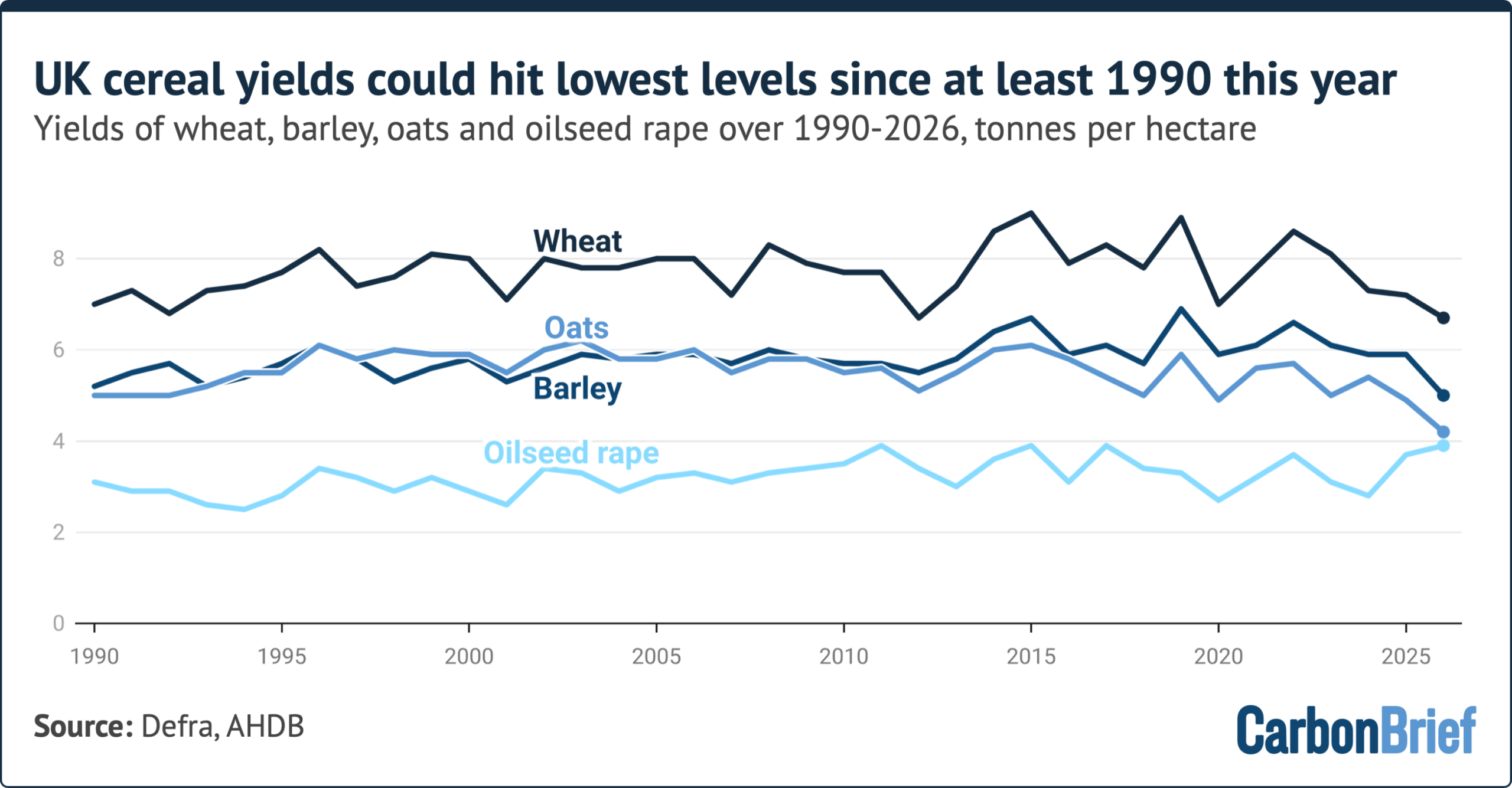
Barley yields could fall by 15%, oats by 14% and wheat yields by 6% year-on-year, according to 2026 harvest surveys from the Agriculture and Horticulture Development Board, a non-departmental public body that provides agricultural data to the UK government.
ECIU said that, even if the situation improves, this year is still expected to be one of the five worst harvests on record. This means that four of the five worst harvests in the UK have occurred in the past decade.
Consumers will likely see higher prices and/or smaller vegetables in supermarkets as a result, Tim O’Malley, chairman of UK company Nationwide Produce, told BBC News in August.
Other crops, such as berries, have grown successfully in the extreme heat. But the Guardian noted fears this could dip later this year “as plants become exhausted from heavy cropping during the heatwave”.
5. Maize production in France is due to hit a four-decade low
France has been acutely affected by this summer’s extreme weather, with more than 7,300 excess deaths during heatwaves and a record number of weather stations recording temperatures of above 40C.
The country is the EU’s largest agricultural producer, but heat, drought and wildfires have affected many crops.
The chart below shows that maize production is set to drop by more than one-third (35%) year-on-year.
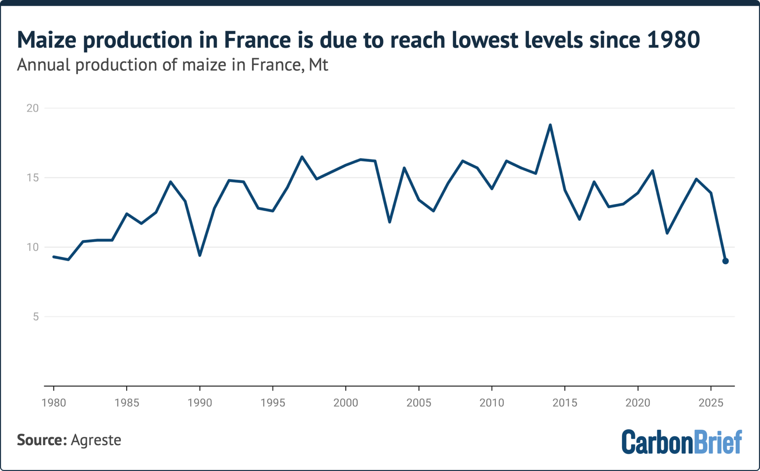
This could result in France’s lowest maize production since 1980, according to data from Agreste, the country’s agriculture ministry’s statistics service.
Due to the heat, “record-early” grape harvests have also been recorded in various parts of the nation since mid-July, reported Le Monde. In some cases, this means “smaller, less juicy grapes, which will yield less wine”, explained the newspaper.
6. Declines in EU grains since 2025
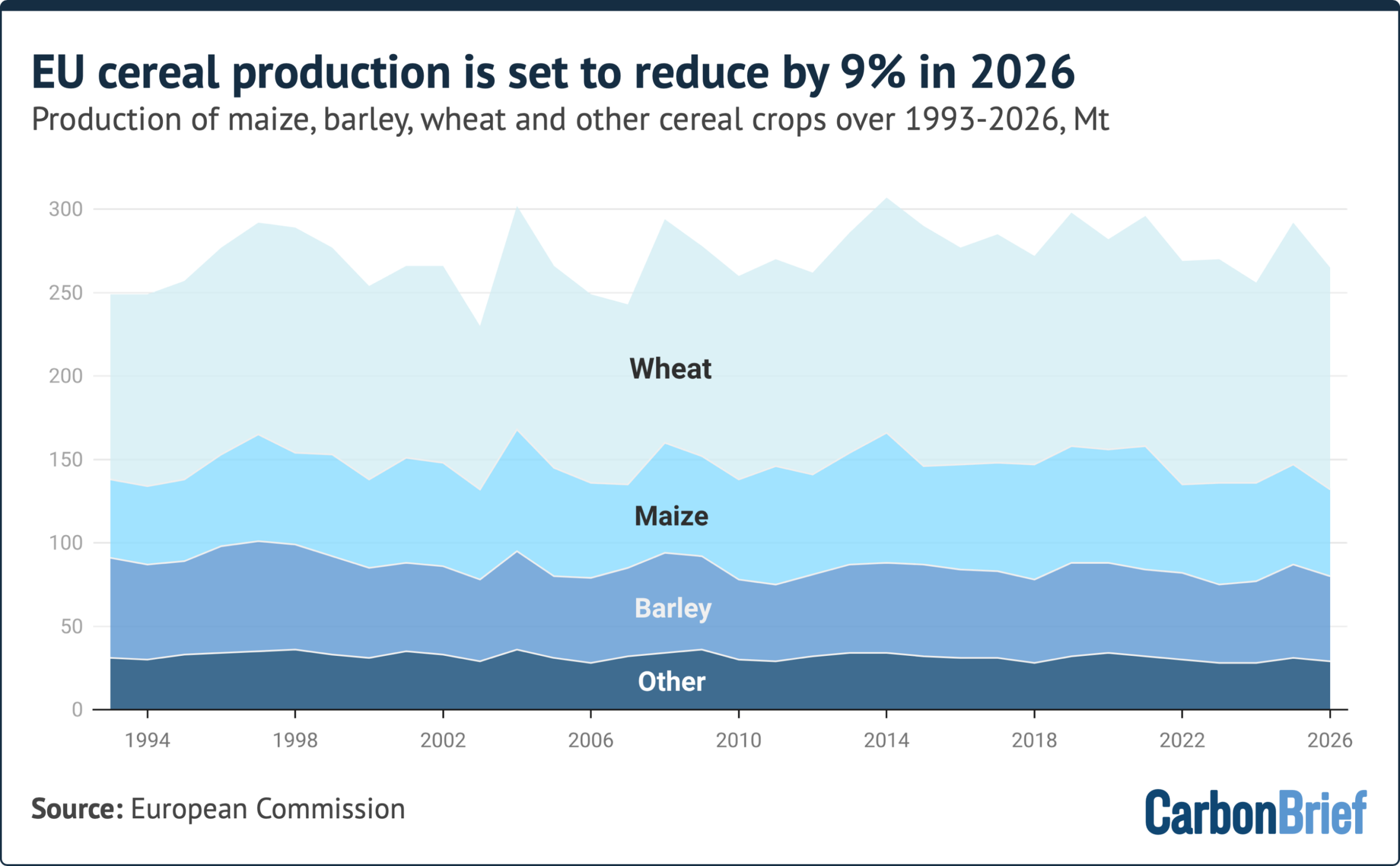
Overall in the EU, data and projections indicate declines in the output of cereal grains this year.
Cereal production is set to fall by 9% compared to 2025, according to the European Commission.
Just one year in the past decade – 2024 – recorded lower production levels.
Maize production is set to be particularly affected, with projections indicating a 13% drop, to 52Mt – the lowest level in the EU since 2007.
The post How this summer’s heat and drought impacted crops in Europe – in six charts appeared first on Carbon Brief.
How this summer’s heat and drought impacted crops in Europe – in six charts



-
Climate Change1 year ago
Guest post: Why China is still building new coal – and when it might stop
-

 Greenhouse Gases2 years ago
嘉宾来稿:满足中国增长的用电需求 光伏加储能“比新建煤电更实惠”
-
Greenhouse Gases1 year ago
Guest post: Why China is still building new coal – and when it might stop
-

 Climate Change2 years ago
嘉宾来稿:满足中国增长的用电需求 光伏加储能“比新建煤电更实惠”
-

 Renewable Energy11 months ago
Sending Progressive Philanthropist George Soros to Prison?
-
Climate Change2 years ago
Bill Discounting Climate Change in Florida’s Energy Policy Awaits DeSantis’ Approval
-
Greenhouse Gases1 year ago
嘉宾来稿:探究火山喷发如何影响气候预测
-

 Carbon Footprint2 years ago
US SEC’s Climate Disclosure Rules Spur Renewed Interest in Carbon Credits