

As it passes its midway point, 2025 is on track to be the second or third warmest year on record, Carbon Brief analysis shows.
However, it is very unlikely to beat 2024 as the hottest year.
This is not surprising, as 2024’s record temperatures were boosted by a strong El Niño event that has now faded.
The analysis also finds there is a less than 10% chance that average temperatures in 2025 will be more than 1.5C above pre-industrial levels.
However, with long-term warming trending strongly upward and, potentially, accelerating, the world is expected to firmly pass the Paris Agreement 1.5C target – which refers to long-term warming, rather than annual temperatures – in the next five years.
In this latest state of the climate quarterly update, Carbon Brief finds:
- So far, 2025 has seen record warm temperatures in January, the third warmest February and June and the second warmest monthly temperatures for March through May on record.
- The world, as a whole, has warmed approximately 1.1C since 1970 – and around 1.4C since the mid-1800s.
- Neutral El Niño Southern Oscillation (ENSO) conditions are expected to persist for the remainder of the year and into 2025.
- Arctic sea ice extent hit record low levels for much of June and into early July – and remains well below the historical range (1979-2010).
Second-warmest first six months of the year
In this assessment, Carbon Brief analyses records from five different research groups that report global surface temperature records: NASA, NOAA, Met Office Hadley Centre/UEA, Berkeley Earth and Copernicus/ECMWF.
These records are combined into an aggregate that reflects a single best-estimate, following the approach used by the World Meteorological Organization (WMO).
The first six months of 2025 have been very warm, each of them coming in the top-three warmest on record across all the different scientific groups that report on global surface temperatures. This is despite the presence of moderate La Niña conditions in the tropical Pacific at the start of the year, which typically suppress global temperatures.
The table below shows the rank of each month in 2025 relative to all the months since the dataset began (1850 for NOAA, Hadley/UAE and Berkeley Earth, 1880 for NASA, and 1940 for Copernicus/ECMWF). Hadley/UAE has been unusually slow in reporting data in 2025 and currently only has global mean surface temperature value available up to February.
It demonstrates how January 2025 was the warmest January on record in the WMO aggregate, March, April and May the second warmest and February and June the third warmest.
| Monthly rank | NASA | NOAA | Hadley/UAE | Berkeley Earth | Copernicus / ECMWF | WMO avg |
|---|---|---|---|---|---|---|
| Jan | 1st | 1st | 1st | 1st | 1st | 1st |
| Feb | 3rd | 3rd | 3rd | 3rd | 3rd | 3rd |
| Mar | 2nd | 1st | 1st | 2nd | 2nd | |
| Apr | 2nd | 2nd | 2nd | 2nd | 2nd | |
| May | 2nd | 2nd | 2nd | 2nd | 2nd | |
| Jun | 3rd | 3rd | 3rd | 3rd | 3rd |
When combined, the first six months of the year in 2025 were the second warmest first half of the year in the historical record. Temperatures averaged at just 0.08C below the record set in 2024 after the peak of a strong El Niño event, as shown in the figure below.

When combined, the first six months of the year in 2025 were the second warmest first half of the year in the historical record. Temperatures averaged at just 0.08C below the record set in 2024 after the peak of a strong El Niño event, as shown in the figure below.

Global surface temperature is currently around 1.4C above preindustrial levels – in-line with the best estimate of the human contribution to global warming. Most of this warming – around 1.1C – has happened just since 1970.
However, global surface temperatures have been declining in May, April and June from highs at the beginning of 2025. This is driven in part by continued cooling of sea surface temperatures after an El Niño-driven peak in early 2024, as well as a contribution from short-lived weak La Niña conditions at the start of the year.
The figure below shows a range of different forecast models for ENSO conditions for the rest of this year, produced by different scientific groups. The values shown are sea surface temperature variations in the tropical Pacific – known as the El Niño 3.4 region – for overlapping three-month periods.

Neutral ENSO conditions are expected to persist through the start of 2026 in most models, with a handful of models showing a return to weak La Niña conditions (defined as El Niño 3.4 region sea surface temperatures under-0.5C) in the autumn and winter months. No models expect the development of El Niño conditions in 2025 and early 2026.
On track to be the second or third warmest year
Carbon Brief has created a projection of what the final global average temperature for 2025 will likely be by looking at the relationship between January-June temperatures and the annual average for each year since 1970. The projection also takes into account ENSO conditions in the first six months of the year and their projected development.
The analysis includes the estimated uncertainty in 2025 outcomes, given that temperature averages from only the first quarter of the year are available so far.
The chart below shows the expected range of 2025 temperatures using the WMO aggregate – including a best-estimate (red) and year-to-date value (yellow). Temperatures are shown with respect to the pre-industrial baseline period (1850-1900).

Carbon Brief’s projection suggests that 2025 is virtually certain to be one of the top-three warmest years on record, with a best-estimate suggesting that global average temperatures will be approximately equal to 2023.
Currently, there is a less than 1% chance of 2025 being the warmest year on record, a 51% chance of it being the second warmest and a 49% chance of it being the third warmest. There is a roughly 9% chance that 2025 annual temperatures will exceed 1.5C above pre-industrial levels.
(A single year exceeding 1.5C is not equivalent to a breach of the Paris Agreement goal to limit temperature increases to 1.5C, which has been widely interpreted to mean temperature averages over 20 years.)
The figure below shows Carbon Brief’s estimate of 2025 temperatures using the WMO aggregate, both at the beginning of the year and once each month’s data has come in. The estimate jumped notably after 2025 saw the warmest January on record, but has been relatively stable over the past six months.

Record or near-record warmth in many regions
While global average temperatures are an important indicator of changes to the broader climate system over time as a result of human activities, these impacts will differ as some regions experience more rapid warming or extreme heat events than is reflected in the global average.
The figure below shows the temperature anomalies for the first six months of the year relative to the 1951-1980 baseline period used by Berkeley Earth. Virtually the whole planet except a small area off the coast of Baja Mexico and in Antarctica saw temperatures warmer than that baseline, with much of Europe and Asia around 2C warmer than the 1951-1980 period.
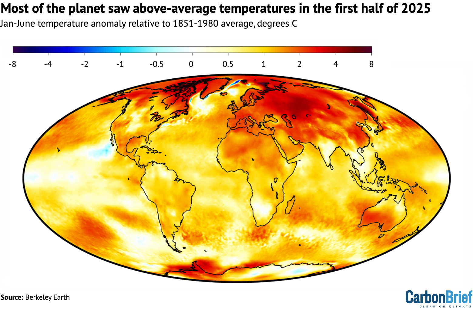
A number of areas saw record warm temperatures over January through to June in the Berkeley Earth dataset, compared to all prior years since the global temperature record began in 1850.
The figure below shows areas of record warm temperatures in dark red; there were no areas with record – or even top-five – cool temperatures. (For more, read Carbon Brief’s factcheck on how climate change is not making extreme cold more common).

Notable areas of record warmth include much of China, south-west Australia and the Mediterranean region. Western Europe, in general, was quite warm, though most land areas did not see a new record set. Overall, approximately 7% of the surface saw record warming in the first six months of the year.
In June, the western Mediterranean saw particularly exceptional warmth, as shown in the figure below. This marine heatwave was driven by a combination of short-term natural variability on top of the long-term warming trend in the region.
The temperature increase in the western Mediterranean region in July – relative to the long-term warming trend – represents the largest short-term increase in temperatures for the region since June 2003, which was a precursor to a devastating heatwave that is believed to have killed 70,000 people.

Record-low Arctic sea ice extent in June
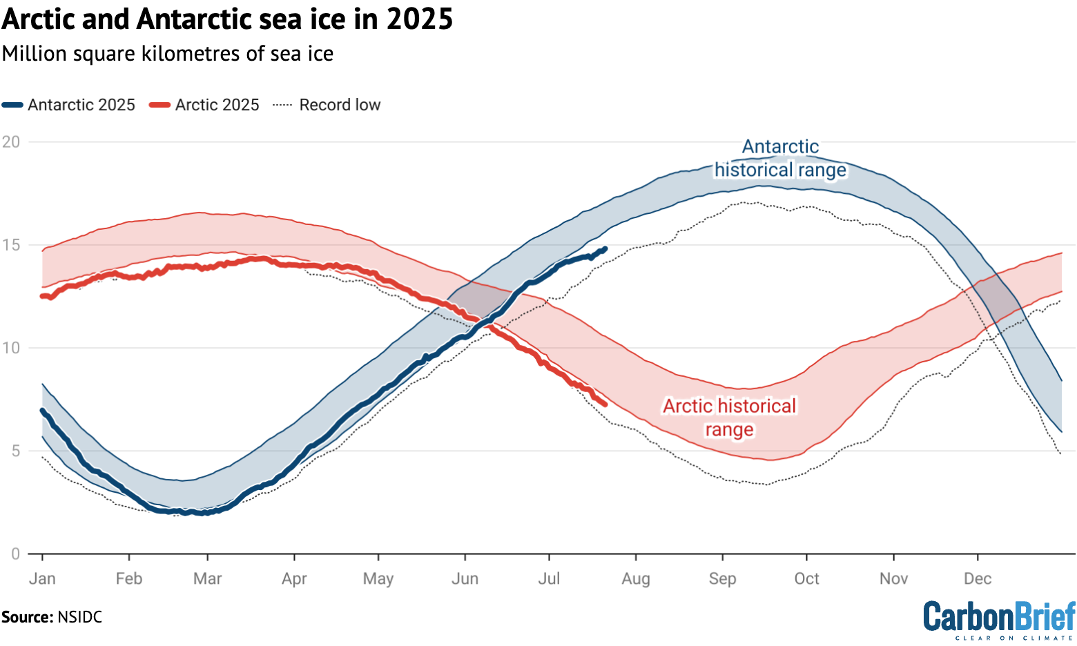
Arctic sea ice extent saw record lows for much of June 2025 and early July, moving out of record territory in mid-July, but remaining far below the historical range (1979-2010).
Antarctic sea ice extent has been at the low end of the historical range for much of the year, but has not set new records aside from a brief period in late February and early March.
The figure below shows both Arctic and Antarctic sea ice extent in 2025 (solid red and blue lines), the historical range in the record between 1979 and 2010 (shaded areas) and the record lows (dotted black line).
Unlike global temperature records, which only report monthly averages, sea ice data is collected and updated on a daily basis, allowing sea ice extent to be viewed up to the present.
However, this dataset – which has been continuously measured by satellites and assembled by the US National Snow and Ice Data Center (NSIDC) since 1979 – may soon be less available.
The US Department of Defence is planning to cease provision of satellite sea ice extent data to the NSIDC at the end of July. While some other satellite instruments can be used to help fill in the gaps, the change will degrade the scientific ability to effectively track this key climate variable.


The post State of the climate: 2025 on track to be second or third warmest year on record appeared first on Carbon Brief.
State of the climate: 2025 on track to be second or third warmest year on record

Drought and heatwaves occurring together – known as “compound” events – have “surged” across the world since the early 2000s, a new study shows.
Compound drought and heat events (CDHEs) can have devastating effects, creating the ideal conditions for intense wildfires, such as Australia’s “Black Summer” of 2019-20 where bushfires burned 24m hectares and killed 33 people.
The research, published in Science Advances, finds that the increase in CDHEs is predominantly being driven by events that start with a heatwave.
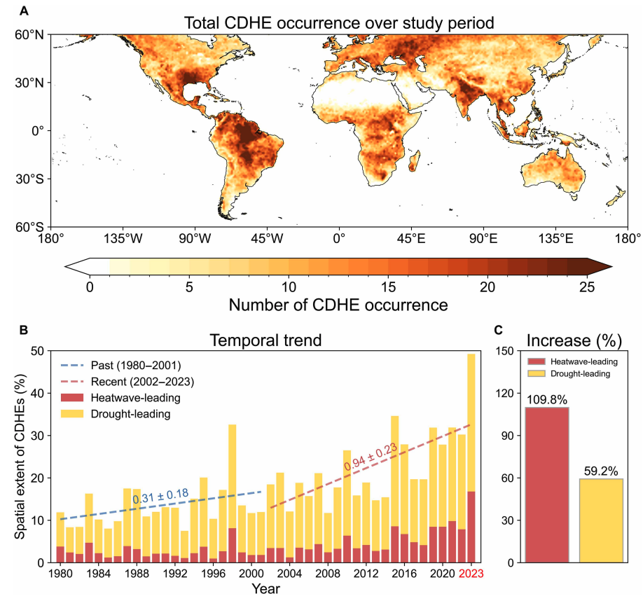
The global area affected by such “heatwave-led” compound events has more than doubled between 1980-2001 and 2002-23, the study says.
The rapid increase in these events over the last 23 years cannot be explained solely by global warming, the authors note.
Since the late 1990s, feedbacks between the land and the atmosphere have become stronger, making heatwaves more likely to trigger drought conditions, they explain.
One of the study authors tells Carbon Brief that societies must pay greater attention to compound events, which can “cause severe impacts on ecosystems, agriculture and society”.
Compound events
CDHEs are extreme weather events where drought and heatwave conditions occur simultaneously – or shortly after each other – in the same region.
These events are often triggered by large-scale weather patterns, such as “blocking” highs, which can produce “prolonged” hot and dry conditions, according to the study.
Prof Sang-Wook Yeh is one of the study authors and a professor at the Ewha Womans University in South Korea. He tells Carbon Brief:
“When heatwaves and droughts occur together, the two hazards reinforce each other through land-atmosphere interactions. This amplifies surface heating and soil moisture deficits, making compound events more intense and damaging than single hazards.”
CDHEs can begin with either a heatwave or a drought.
The sequence of these extremes is important, the study says, as they have different drivers and impacts.
For example, in a CDHE where the heatwave was the precursor, increased direct sunshine causes more moisture loss from soils and plants, leading to a drought.
Conversely, in an event where the drought was the precursor, the lack of soil moisture means that less of the sun’s energy goes into evaporation and more goes into warming the Earth’s surface. This produces favourable conditions for heatwaves.
The study shows that the majority of CDHEs globally start out as a drought.
In recent years, there has been increasing focus on these events due to the devastating impact they have on agriculture, ecosystems and public health.
In Russia in the summer of 2010, a compound drought-heatwave event – and the associated wildfires – caused the death of nearly 55,000 people, the study notes.

The record-breaking Pacific north-west “heat dome” in 2021 triggered extreme drought conditions that caused “significant declines” in wheat yields, as well as in barley, canola and fruit production in British Columbia and Alberta, Canada, says the study.
Increasing events
To assess how CDHEs are changing, the researchers use daily reanalysis data to identify droughts and heatwaves events. (Reanalysis data combines past observations with climate models to create a historical climate record.) Then, using an algorithm, they analyse how these events overlap in both time and space.
The study covers the period from 1980 to 2023 and the world’s land surface, excluding polar regions where CDHEs are rare.
The research finds that the area of land affected by CDHEs has “increased substantially” since the early 2000s.
Heatwave-led events have been the main contributor to this increase, the study says, with their spatial extent rising 110% between 1980-2001 and 2002-23, compared to a 59% increase for drought-led events.
The map below shows the global distribution of CDHEs over 1980-2023. The charts show the percentage of the land surface affected by a heatwave-led CDHE (red) or a drought-led CDHE (yellow) in a given year (left) and relative increase in each CDHE type (right).
The study finds that CDHEs have occurred most frequently in northern South America, the southern US, eastern Europe, central Africa and south Asia.
Threshold passed
The authors explain that the increase in heatwave-led CDHEs is related to rising global temperatures, but that this does not tell the whole story.
In the earlier 22-year period of 1980-2001, the study finds that the spatial extent of heatwave-led CDHEs rises by 1.6% per 1C of global temperature rise. For the more-recent period of 2022-23, this increases “nearly eightfold” to 13.1%.
The change suggests that the rapid increase in the heatwave-led CDHEs occurred after the global average temperature “surpasse[d] a certain temperature threshold”, the paper says.
This threshold is an absolute global average temperature of 14.3C, the authors estimate (based on an 11-year average), which the world passed around the year 2000.
Investigating the recent surge in heatwave-leading CDHEs further, the researchers find a “regime shift” in land-atmosphere dynamics “toward a persistently intensified state after the late 1990s”.
In other words, the way that drier soils drive higher surface temperatures, and vice versa, is becoming stronger, resulting in more heatwave-led compound events.
Daily data
The research has some advantages over other previous studies, Yeh says. For instance, the new work uses daily estimations of CDHEs, compared to monthly data used in past research. This is “important for capturing the detailed occurrence” of these events, says Yeh.
He adds that another advantage of their study is that it distinguishes the sequence of droughts and heatwaves, which allows them to “better understand the differences” in the characteristics of CDHEs.
Dr Meryem Tanarhte is a climate scientist at the University Hassan II in Morocco, and Dr Ruth Cerezo Mota is a climatologist and a researcher at the National Autonomous University of Mexico. Both scientists, who were not involved in the study, agree that the daily estimations give a clearer picture of how CDHEs are changing.
Cerezo-Mota adds that another major contribution of the study is its global focus. She tells Carbon Brief that in some regions, such as Mexico and Africa, there is a lack of studies on CDHEs:
“Not because the events do not occur, but perhaps because [these regions] do not have all the data or the expertise to do so.”
However, she notes that the reanalysis data used by the study does have limitations with how it represents rainfall in some parts of the world.
Compound impacts
The study notes that if CDHEs continue to intensify – particularly events where heatwaves are the precursors – they could drive declining crop productivity, increased wildfire frequency and severe public health crises.
These impacts could be “much more rapid and severe as global warming continues”, Yeh tells Carbon Brief.
Tanarhte notes that these events can be forecasted up to 10 days ahead in many regions. Furthermore, she says, the strongest impacts can be prevented “through preparedness and adaptation”, including through “water management for agriculture, heatwave mitigation measures and wildfire mitigation”.
The study recommends reassessing current risk management strategies for these compound events. It also suggests incorporating the sequences of drought and heatwaves into compound event analysis frameworks “to enhance climate risk management”.
Cerezo-Mota says that it is clear that the world needs to be prepared for the increased occurrence of these events. She tells Carbon Brief:
“These [risk assessments and strategies] need to be carried out at the local level to understand the complexities of each region.”




The post Heatwaves driving recent ‘surge’ in compound drought and heat extremes appeared first on Carbon Brief.
Heatwaves driving recent ‘surge’ in compound drought and heat extremes