“Natural” world heritage sites, such as the Galápagos Islands, Serengeti national park and Great Barrier Reef, could be exposed to multiple climate extremes by the end of the century, researchers warn.
The study, published in Communications Earth & Environment, assesses the impacts of extreme heat, rainfall and drought on 250 natural world heritage sites, under different warming scenarios.
Natural world heritage sites are areas recognised by the UN Educational, Scientific and Cultural Organization (Unesco) for their “natural beauty or outstanding biodiversity, ecosystem and geological values”.
The authors find that, under a low-warming scenario, 33 of the 250 heritage sites will face at least one “climate pressure” by the end of the century. Under a moderate scenario, this number rises to 188 sites, they find.
Under the highest warming scenarios, the authors find that nearly all sites will experience extreme heat exposure, with many also facing the compounding impacts of drought or extreme rainfall.
The study warns that sites located at mid-latitudes and in tropical regions, which are often important hotspots for biodiversity, are likely to face the greatest climate risk as the planet warms.
Heat, rain and drought
Recognised internationally as the most important ecosystems on Earth, natural world heritage sites are legally protected under the World Heritage Convention, an international conservation treaty.
But, as the climate warms, natural world heritage sites are facing increasing threats from extreme weather events. In this study, the authors focus on extreme heat, drought and rainfall at 250 of 266 Unesco’s natural world heritage sites.
To assess exposure to climate extremes over the coming century, the authors use climate models from the sixth Coupled Model Intercomparison Project (CMIP6). They use four different Shared Socioeconomic Pathways (SSPs), listed below.
- SSP1-2.6: A “low” warming pathway in which global temperatures stay below 2C warming with implied net-zero emissions in the second half of the century.
- SSP2-4.5”: An “intermediate” warming pathway roughly in line with the upper end of combined pledges under the Paris Agreement, which results in around 2.7C warming by the end of the 21st century.
- SSP3-7.0: A “high” warming pathway, which assumes no additional climate policy, with “particularly high non-CO2 emissions, including high aerosols emissions”.
- SSP5-8.5: A “very high” pathway with no additional climate policy.

The Ilulissat Icefjord is an actively calving ice sheet located on the west coast of Greenland, around 250km north of the Arctic Circle. It is one of the few sites where ice from the Greenland ice cap directly enters the sea.
According to the world heritage outlook, “climate change is the greatest current threat” to the site. It adds that “in the next decades there will be higher temperatures both in summer and winter, increased heavy precipitation (>10 mm), and around 2050 the distribution of pack ice will be noticeably decreased”.
The study finds that that site will face “no climate pressure” under the SSP126 scenario. However, it will experience “heavy rain” under SSP245, and will face both heavy rain and extreme heat under SSP370 and SSP585.
Credit: Realimage / Alamy Stock Photo
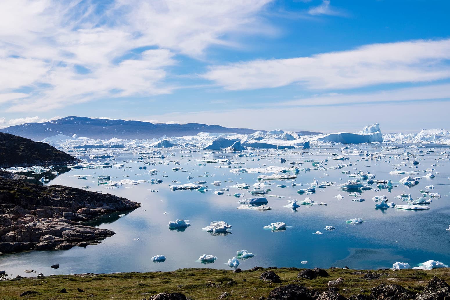
The Ilulissat Icefjord is an actively calving ice sheet located on the west coast of Greenland, around 250km north of the Arctic Circle. It is one of the few sites where ice from the Greenland ice cap directly enters the sea.
According to the world heritage outlook, “climate change is the greatest current threat” to the site. It adds that “in the next decades there will be higher temperatures both in summer and winter, increased heavy precipitation (>10 mm), and around 2050 the distribution of pack ice will be noticeably decreased”.
The study finds that that site will face “no climate pressure” under the SSP126 scenario. However, it will experience “heavy rain” under SSP245, and will face both heavy rain and extreme heat under SSP370 and SSP585.
Credit: Realimage / Alamy Stock Photo
The authors use the highest daily maximum temperature in a year to measure changes in extreme heat and the annual maximum one-day precipitation to track rainfall. For drought, they use an indicator that calculates the difference between rainfall and evapotranspiration (the transfer of water from the ground into the air through a combination of evaporation and transpiration).
The authors define a site as “being exposed to a climate extreme” when heat, rainfall or drought intensity exceeds a defined threshold by 2100, under any warming pathways explored.
The researchers established the “threshold value” for extreme heat, precipitation or drought based on the first 10 years of simulated data under SSP2-4.5 – a modest mitigation pathway where emissions remain close to current levels.
Dr Guolong Chen is a researcher at Peking University and lead author on the report. He tells Carbon Brief that the authors chose the intermediate SSP pathway to set the threshold because it “is a more balanced and realistic representation” of the climate than the other pathway. He adds that they decided to take a 10-year average “to reduce the fluctuations in model simulations”.
Mapped
The maps below shows which natural world heritage sites will face climate impacts under different warming pathways. The dots are coloured red if the site will face climate impacts from heat, drought or extreme rainfall by the year 2100 under low (top left), intermediate (top right), high (bottom left) and very high (bottom right) warming pathway.

The maps show that under the low warming pathway, the thresholds for extreme heat, drought or rainfall will only be crossed in 33 of the 150 sites. Many of these are clustered in south-east Asia. The thresholds are not crossed for any of the sites in Europe, the Middle East and North Africa under the low warming scenario.
However, under the two highest-warming pathways, almost all of the 250 sites are expected to be threatened by climate extremes.
The authors also find that a significant portion of natural heritage sites are already experiencing extreme heat, posing challenges to conservation.
The study shows that over 2000-15, 45% of sites faced extreme heat, according to the European Centre for Medium-Range Weather Forecasts (ECMWF) ERA5 temperature dataset.
If global warming is kept in line with the low warming pathway, this number of sites experiencing extreme heat will decrease to 2% by the end of the century, according to the research. However, under all other pathways it would rise, reaching 69% under the intermediate pathway and 98% under the high pathway.
Compound extreme climate events
The study finds that drought and extreme rainfall will be a less widespread threat to natural heritage sites than extreme heat.
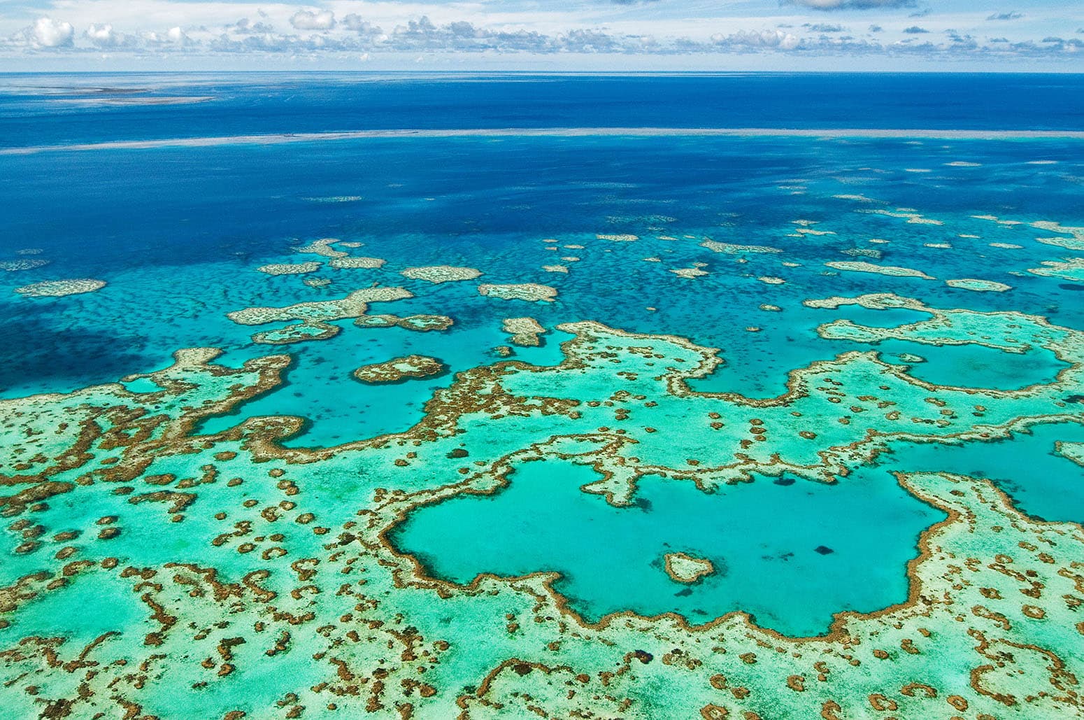
The Great Barrier Reef is one of the most famous natural world heritage sites and the largest living structure on earth. The reef attracts two million visitors a year, provides jobs for around 64,000 people and contributes more than $6.4bn each year to the Australian economy
The study finds that the reef will face an increase in the intensity of extreme heat events compared to the expected climate over the coming decade, under all but the study’s lowest warming pathway.
However, the Great Barrier Reef is already under threat from climate change, as high temperatures cause “coral bleaching”, which can severely damage the reef. Coral bleaching events are becoming more frequent as global temperatures rise, and in 2024, the reef experienced its fifth bleaching in only eight years.
Credit: Ingo Oeland / Alamy Stock Photo
However, the authors warn that the combined influence of temperature and either rainfall or drought extremes could be severe. The percentage of natural world heritage sites exposed to compound extreme climate events rises from 17% under the intermediate warming pathway to 31% under the high warming pathway.
Chen tells Carbon Brief that the study only calculates exposure, and does not “fully consider the varying vulnerability levels across different sites”. As a result, the analysis may not capture the worsening impacts of climate change for sites that are already under threat, he says.
Prof Jim Perry is a professor at the University of Minnesota’s department of fisheries, wildlife and conservation biology, and was not involved in the study. He tells Carbon Brief that this study is the most recent and “comprehensive” review of the impacts of climate change on natural world heritage sites.
Biodiversity threat
Natural world heritage sites make up less than 1% of the Earth’s surface, but are home to more than 20% of mapped global species richness.
As a secondary part of their analysis, the authors focus on threats to biodiversity in the most vulnerable natural world heritage sites.
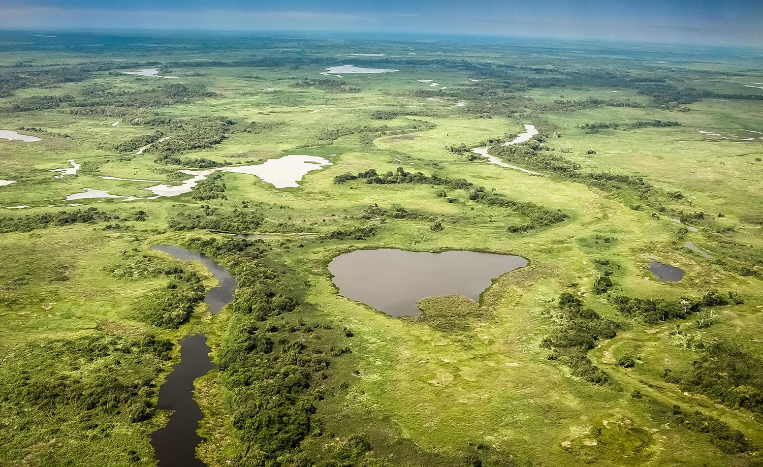
Brazil’s Pantanal conservation complex area is a cluster of four protected areas, which together make up more than 180,000 hectares of land. The site represents 1.3% of Brazil’s Pantanal region – one of the world’s largest freshwater wetland ecosystems – and is protected due to its extensive biodiversity.
A combination of increasing temperatures, decreased rainfall and other human activity has led to an increasing number of wildfires in the region in recent years. A recent attribution study finds that climate change made the “supercharged” wildfires that blazed across the Pantanal in 2024 around 40% more intense.
The study finds that the Pantanal will face “no climate pressure” under the low warming pathway, but that under intermediate warming pathway, heat and drought will both impact the region. Under high and very high pathways, only extreme heat will affect the region, according to the authors.
It adds that “uncontrolled fires could be detrimental for the site’s biodiversity, landscape beauty and wetland ecological functions”.
Credit: Zoonar GmbH / Alamy Stock Photo
Chen tells Carbon Brief that the authors chose to focus on forests for this part of the analysis because they are “highly vulnerable to heat, drought and heavy rainfall due to their dependence on water”.
To assess the damage to biodiversity in forested natural world heritage sites to date, the authors use a metric called the “biodiversity intactness index”. This measures the average proportion of natural biodiversity remaining in local ecosystems. The authors class regions with an index of less than 0.7 to be “severely vulnerable”, and those with an index between 0.7 and 0.8 as “vulnerable”.
The authors identify 14 forested natural world heritage sites in the tropics with indices under 0.8 – mainly located in South America, the mainland in Africa, and on various coasts and islands. These include Brazil’s Pantanal conservation complex, Mount Kenya’s national park and Australia’s Ningaloo Coast.
The study finds that the mid-latitudes and tropical regions are likely to face the greatest climate risk as the planet warms. Lead author Chen explains:
“Tropical regions are home to rich biodiversity and diverse ecosystems, including vital natural land types such as forests. There is a more consistent consensus that temperature increases in tropical areas will have a negative impact on biodiversity, threatening the stability of these ecosystems.”
Prof Martin Falk is a professor at the University of South-Eastern Norway who has conducted research on world heritage sites, but was not involved in this study. He tells Carbon Brief that there are challenges to data collection for research on world heritage sites, noting that site managers typically “underreport climate change risks”. He adds:
“Another issue is that the natural world heritage sites in the Western world are over-researched. There is too little on the sites in developing countries.”


The post Mapped: How ‘natural’ world heritage sites are threatened by climate extremes appeared first on Carbon Brief.
Mapped: How ‘natural’ world heritage sites are threatened by climate extremes

Drought and heatwaves occurring together – known as “compound” events – have “surged” across the world since the early 2000s, a new study shows.
Compound drought and heat events (CDHEs) can have devastating effects, creating the ideal conditions for intense wildfires, such as Australia’s “Black Summer” of 2019-20 where bushfires burned 24m hectares and killed 33 people.
The research, published in Science Advances, finds that the increase in CDHEs is predominantly being driven by events that start with a heatwave.
The global area affected by such “heatwave-led” compound events has more than doubled between 1980-2001 and 2002-23, the study says.
The rapid increase in these events over the last 23 years cannot be explained solely by global warming, the authors note.
Since the late 1990s, feedbacks between the land and the atmosphere have become stronger, making heatwaves more likely to trigger drought conditions, they explain.
One of the study authors tells Carbon Brief that societies must pay greater attention to compound events, which can “cause severe impacts on ecosystems, agriculture and society”.
Compound events
CDHEs are extreme weather events where drought and heatwave conditions occur simultaneously – or shortly after each other – in the same region.
These events are often triggered by large-scale weather patterns, such as “blocking” highs, which can produce “prolonged” hot and dry conditions, according to the study.
Prof Sang-Wook Yeh is one of the study authors and a professor at the Ewha Womans University in South Korea. He tells Carbon Brief:
“When heatwaves and droughts occur together, the two hazards reinforce each other through land-atmosphere interactions. This amplifies surface heating and soil moisture deficits, making compound events more intense and damaging than single hazards.”
CDHEs can begin with either a heatwave or a drought.
The sequence of these extremes is important, the study says, as they have different drivers and impacts.
For example, in a CDHE where the heatwave was the precursor, increased direct sunshine causes more moisture loss from soils and plants, leading to a drought.
Conversely, in an event where the drought was the precursor, the lack of soil moisture means that less of the sun’s energy goes into evaporation and more goes into warming the Earth’s surface. This produces favourable conditions for heatwaves.
The study shows that the majority of CDHEs globally start out as a drought.
In recent years, there has been increasing focus on these events due to the devastating impact they have on agriculture, ecosystems and public health.
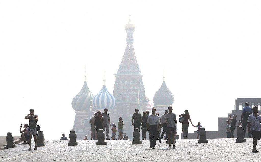
In Russia in the summer of 2010, a compound drought-heatwave event – and the associated wildfires – caused the death of nearly 55,000 people, the study notes.
The record-breaking Pacific north-west “heat dome” in 2021 triggered extreme drought conditions that caused “significant declines” in wheat yields, as well as in barley, canola and fruit production in British Columbia and Alberta, Canada, says the study.
Increasing events
To assess how CDHEs are changing, the researchers use daily reanalysis data to identify droughts and heatwaves events. (Reanalysis data combines past observations with climate models to create a historical climate record.) Then, using an algorithm, they analyse how these events overlap in both time and space.
The study covers the period from 1980 to 2023 and the world’s land surface, excluding polar regions where CDHEs are rare.
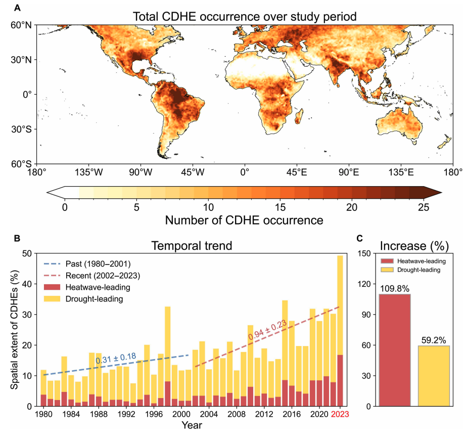
The research finds that the area of land affected by CDHEs has “increased substantially” since the early 2000s.
Heatwave-led events have been the main contributor to this increase, the study says, with their spatial extent rising 110% between 1980-2001 and 2002-23, compared to a 59% increase for drought-led events.
The map below shows the global distribution of CDHEs over 1980-2023. The charts show the percentage of the land surface affected by a heatwave-led CDHE (red) or a drought-led CDHE (yellow) in a given year (left) and relative increase in each CDHE type (right).
The study finds that CDHEs have occurred most frequently in northern South America, the southern US, eastern Europe, central Africa and south Asia.
Threshold passed
The authors explain that the increase in heatwave-led CDHEs is related to rising global temperatures, but that this does not tell the whole story.
In the earlier 22-year period of 1980-2001, the study finds that the spatial extent of heatwave-led CDHEs rises by 1.6% per 1C of global temperature rise. For the more-recent period of 2022-23, this increases “nearly eightfold” to 13.1%.
The change suggests that the rapid increase in the heatwave-led CDHEs occurred after the global average temperature “surpasse[d] a certain temperature threshold”, the paper says.
This threshold is an absolute global average temperature of 14.3C, the authors estimate (based on an 11-year average), which the world passed around the year 2000.
Investigating the recent surge in heatwave-leading CDHEs further, the researchers find a “regime shift” in land-atmosphere dynamics “toward a persistently intensified state after the late 1990s”.
In other words, the way that drier soils drive higher surface temperatures, and vice versa, is becoming stronger, resulting in more heatwave-led compound events.
Daily data
The research has some advantages over other previous studies, Yeh says. For instance, the new work uses daily estimations of CDHEs, compared to monthly data used in past research. This is “important for capturing the detailed occurrence” of these events, says Yeh.
He adds that another advantage of their study is that it distinguishes the sequence of droughts and heatwaves, which allows them to “better understand the differences” in the characteristics of CDHEs.
Dr Meryem Tanarhte is a climate scientist at the University Hassan II in Morocco, and Dr Ruth Cerezo Mota is a climatologist and a researcher at the National Autonomous University of Mexico. Both scientists, who were not involved in the study, agree that the daily estimations give a clearer picture of how CDHEs are changing.
Cerezo-Mota adds that another major contribution of the study is its global focus. She tells Carbon Brief that in some regions, such as Mexico and Africa, there is a lack of studies on CDHEs:
“Not because the events do not occur, but perhaps because [these regions] do not have all the data or the expertise to do so.”
However, she notes that the reanalysis data used by the study does have limitations with how it represents rainfall in some parts of the world.
Compound impacts
The study notes that if CDHEs continue to intensify – particularly events where heatwaves are the precursors – they could drive declining crop productivity, increased wildfire frequency and severe public health crises.
These impacts could be “much more rapid and severe as global warming continues”, Yeh tells Carbon Brief.
Tanarhte notes that these events can be forecasted up to 10 days ahead in many regions. Furthermore, she says, the strongest impacts can be prevented “through preparedness and adaptation”, including through “water management for agriculture, heatwave mitigation measures and wildfire mitigation”.
The study recommends reassessing current risk management strategies for these compound events. It also suggests incorporating the sequences of drought and heatwaves into compound event analysis frameworks “to enhance climate risk management”.
Cerezo-Mota says that it is clear that the world needs to be prepared for the increased occurrence of these events. She tells Carbon Brief:
“These [risk assessments and strategies] need to be carried out at the local level to understand the complexities of each region.”