

Arctic sea ice has recorded its smallest winter peak extent since satellite records began 47 years ago, new data reveals.
Provisional data from the US National Snow and Ice Data Center (NSIDC) shows that Arctic sea ice reached a winter maximum extent of 14.33m square kilometres (km2) last week.
This is 1.31m km2 below the 1981-2010 average maximum and 800,000km2 smaller than the previous low recorded in 2017, according to the data.
Dr Julienne Stroeve, a senior scientist at the NSIDC, tells Carbon Brief that such a small winter peak “doesn’t mean a record-low” summer minimum will necessarily follow in September.
But, she adds, it does “continue the overall long-term decline in the ice cover”.
Meanwhile, Antarctic sea ice reached its summer minimum extent earlier this month, with 2025 tying with 2022 and 2024 for the second-smallest summer low on record, the NSIDC says.
The combination of reduced sea ice cover in both the Arctic and Antarctic means that global sea ice extent dwindled to an “all-time minimum” in February this year, according to the Copernicus Climate Change Service (C3S).
Record low
Arctic sea ice extent changes throughout the year. It grows during the winter towards its annual maximum extent – often referred to as its “winter peak” – in February or March. It then melts throughout the spring and summer towards its September minimum.
Using satellite data, scientists can track the growth and melt of sea ice, allowing them to determine the size of the ice sheet’s winter maximum extent. This is a key way to monitor the “health” of the Arctic sea ice.
On 22 March 2025, Arctic sea ice reached its smallest-ever winter peak, according to the NSIDC. At 14.33m km2, this was 1.31m km2 below the 1981-2010 average maximum and 800,000km2 below the previous low, which was recorded in 2017.
The chart below shows Arctic sea ice extent over the satellite era (1978 to the present day). Red indicates the 2025 extent, while shades of blue indicate different years over 1978-2024.

Daily Arctic sea ice extent (in millions of km2) over the satellite era (1978 to present), where lines indicate individual years. This year is shown in red, while darker blues indicate more recent years. The dashed line indicates the record low. Credit: Carbon Brief
NSIDC senior research scientist Dr Walt Meier told the Press Association:
“This new record low is yet another indicator of how Arctic sea ice has fundamentally changed from earlier decades. But, even more importantly than the record low, is that this year adds yet another data point to the continuing long-term loss of Arctic sea ice in all seasons.”
Freeze season
The growth season for Arctic sea ice kicked off after reaching its summer minimum extent of 4.28m km2 on 11 September last year. This was the Arctic’s seventh-lowest summer low on record.
As temperatures cooled, the NSIDC says that Arctic sea ice grew slowly at the start of October. Ice growth then sped up towards the middle of the month and then slowed again towards its end. The average sea ice extent for October was 5.94m km2 – the fourth lowest on record, according to the NSIDC.
Throughout November, air temperatures over the Arctic Ocean were “mixed”, according to the NSIDC. It says that temperatures were above average from coastal Canada to northern Scandinavia, as well as in the area north of Greenland, but below average over the Beaufort, Bering and Laptev Seas.

Arctic sea ice grew at a steady pace for most of November – mainly in the Kara, Beaufort and Chukchi Seas, as well as Baffin Bay and the Canadian Arctic archipelago. However, in the Hudson Bay – where air temperatures were 1-5C above average – “no appreciable sea ice” formed, according to the NSIDC.
The November extent averaged 9.11m km2, ranking the third lowest in the satellite record and 1.59mkm2 below the 1981-2010 average, the NSIDC says.
December saw above-average air temperatures over “essentially all of the Arctic Ocean”, with a particularly “prominent” area of warmth off the Canadian Arctic archipelago and Greenland, the NSIDC says.
Due to delayed ice growth in the Hudson Bay and low extent in the northern Barents Sea, December Arctic sea ice extent was the lowest in the satellite record at 11.43m km2.

Daily Arctic sea ice extent decreased sharply at the end of January, when the region lost about 0.3m km2 – an area roughly the size of Italy – in less than a week, according to C3S.
It adds that “such a rapid decrease is unusual at this time of year, when sea ice is typically expanding towards its annual maximum”. It points to the “pronounced warm event” over the Greenland Sea and Svalbard region as the reason for the drop.
Dr Rick Thoman – a specialist in the Alaskan climate from the University of Alaska Fairbanks – tells Carbon Brief that the sea ice decrease in late January and early February was partially driven by “separate cyclones producing simultaneous south winds across much of the Barents and Bering Seas”. As winds pushed the ice northwards, “ocean wave action” melted the thin ice at the edge of the ice sheet, he says.
February was marked by slow Arctic sea ice growth, resulting in a record-low February Arctic sea ice extent of 13.75m km2, according to the NSIDC. The organisation adds that daily sea ice growth “stalled” twice in the month, which “helped to contribute to low ice conditions and led to overall ice retreat in the Barents Sea”.
This rapid melt was partially driven by above-average temperatures. Between northern Greenland and the north pole, temperatures reached up to 12C above average, the NSIDC says.

Antarctic melt
At the south pole, Antarctic sea ice has been declining during the southern hemisphere summer. It reached its annual minimum of 1.98m km2 on 1 March.
This summer low ties with 2022 and 2024 for the second-smallest Antarctic extent in the 47-year satellite record, the NSIDC says. It adds that the past four years are the only years on record in which Antarctic sea ice has reached a minimum below 2m km2.
The graphic below shows Antarctic sea ice extent over the satellite era. Red indicates the 2025 extent and shades of blue indicate different years over 1978-2023.

Daily global sea ice extent (in millions of km2) over the satellite era (1978 to present), where lines indicate individual years. This year is shown in red, while darker blues indicate more recent years. The dashed line indicates the record low. Credit: Carbon Brief
The melt season for Antarctic sea ice began with its winter maximum of 17.2m km2 on 19 September 2024.
This was 1.6m km2 smaller than the 1981-2010 average maximum and the second-lowest winter peak on record, according to the NSIDC.
As the southern hemisphere warmed, Antarctic sea ice began to melt. Throughout October, Antarctic sea ice extent continued to rank the second lowest on the satellite record following the record-breaking 2023 season, the NSIDC says.
It adds that “seasonal ice loss was relatively slow during the early part of the month, but the pace picked up substantially during the last week of October, approaching 2023 values”.
By 30 November, Antarctic sea ice was the third lowest on record, tracking higher than the 2023 and 2016 levels for the same date, the NSIDC says.

After a “prolonged period of record to near-record daily lows set in 2023 and 2024”, December 2024 saw Antarctic sea ice loss slow down, with the average rate of decline tracking “well below average”.
By the end of December 2025, Antarctic sea ice extent was roughly in line with the 1981-2010 average, according to the NSIDC.
As a result, it says that “speculation that the Antarctic had entered a new regime of strongly reduced Antarctic sea ice related to oceanic influences, has, at least temporarily, come to an end”.
It adds that sea ice extent was “above average over the western Weddell and Amundsen Seas and slightly below average in the Ross Sea, with near-average extents in other areas”.
Throughout February, Antarctic sea ice continued to melt – especially in the eastern Ross Sea and Amunsden sea, where ice concentration is low, according to the NSIDC.
Global ‘all-time minimum’
With sea ice at or around record lows in both the Arctic and Antarctic, global sea ice extent dropped to an “all-time minimum” in February this year, according to the Copernicus Climate Change Service (C3S).
Global sea ice hit a new daily low in early February and remained below the previous record from 2023 for the rest of the month, C3S says.
The graphic below shows global sea ice extent over 1978-2025, where red indicates the 2025 extent and shades of blue indicate different years.

Daily Antarctic sea ice extent (in millions of km2) over the satellite era (1978 to present), where lines indicate individual years. This year is shown in red, while darker blues indicate more recent years. The dashed line indicates the record low. Credit: Carbon Brief
C3S deputy director Dr Samantha Burgess noted that the low sea ice came as “February 2025 continues the streak of record or near-record temperatures observed throughout the last two years”. She added:
“One of the consequences of a warmer world is melting sea ice – and the record or near-record low sea ice cover at both poles has pushed global sea ice cover to an all-time minimum.”
The story was picked up in newspapers around the world, including the Guardian, Hindustan Times and Washington Post.
In response to the news from C3DS, Prof Richard Allan – a professor of climate science at the University of Reading – warned that “the long-term prognosis for Arctic sea ice is grim”. He added:
“Averaging over all regions the global warming trend is clear, with February 2025 more than 1.5C above pre-industrial conditions, repeating a level of excess warmth experienced in all but one of the past 20 months despite a weak cooling influence of La Niña conditions in the Pacific.”



The post Arctic sea ice winter peak in 2025 is smallest in 47-year record appeared first on Carbon Brief.
Arctic sea ice winter peak in 2025 is smallest in 47-year record

Drought and heatwaves occurring together – known as “compound” events – have “surged” across the world since the early 2000s, a new study shows.
Compound drought and heat events (CDHEs) can have devastating effects, creating the ideal conditions for intense wildfires, such as Australia’s “Black Summer” of 2019-20 where bushfires burned 24m hectares and killed 33 people.
The research, published in Science Advances, finds that the increase in CDHEs is predominantly being driven by events that start with a heatwave.
The global area affected by such “heatwave-led” compound events has more than doubled between 1980-2001 and 2002-23, the study says.
The rapid increase in these events over the last 23 years cannot be explained solely by global warming, the authors note.
Since the late 1990s, feedbacks between the land and the atmosphere have become stronger, making heatwaves more likely to trigger drought conditions, they explain.
One of the study authors tells Carbon Brief that societies must pay greater attention to compound events, which can “cause severe impacts on ecosystems, agriculture and society”.
Compound events
CDHEs are extreme weather events where drought and heatwave conditions occur simultaneously – or shortly after each other – in the same region.
These events are often triggered by large-scale weather patterns, such as “blocking” highs, which can produce “prolonged” hot and dry conditions, according to the study.
Prof Sang-Wook Yeh is one of the study authors and a professor at the Ewha Womans University in South Korea. He tells Carbon Brief:
“When heatwaves and droughts occur together, the two hazards reinforce each other through land-atmosphere interactions. This amplifies surface heating and soil moisture deficits, making compound events more intense and damaging than single hazards.”
CDHEs can begin with either a heatwave or a drought.
The sequence of these extremes is important, the study says, as they have different drivers and impacts.
For example, in a CDHE where the heatwave was the precursor, increased direct sunshine causes more moisture loss from soils and plants, leading to a drought.
Conversely, in an event where the drought was the precursor, the lack of soil moisture means that less of the sun’s energy goes into evaporation and more goes into warming the Earth’s surface. This produces favourable conditions for heatwaves.
The study shows that the majority of CDHEs globally start out as a drought.
In recent years, there has been increasing focus on these events due to the devastating impact they have on agriculture, ecosystems and public health.
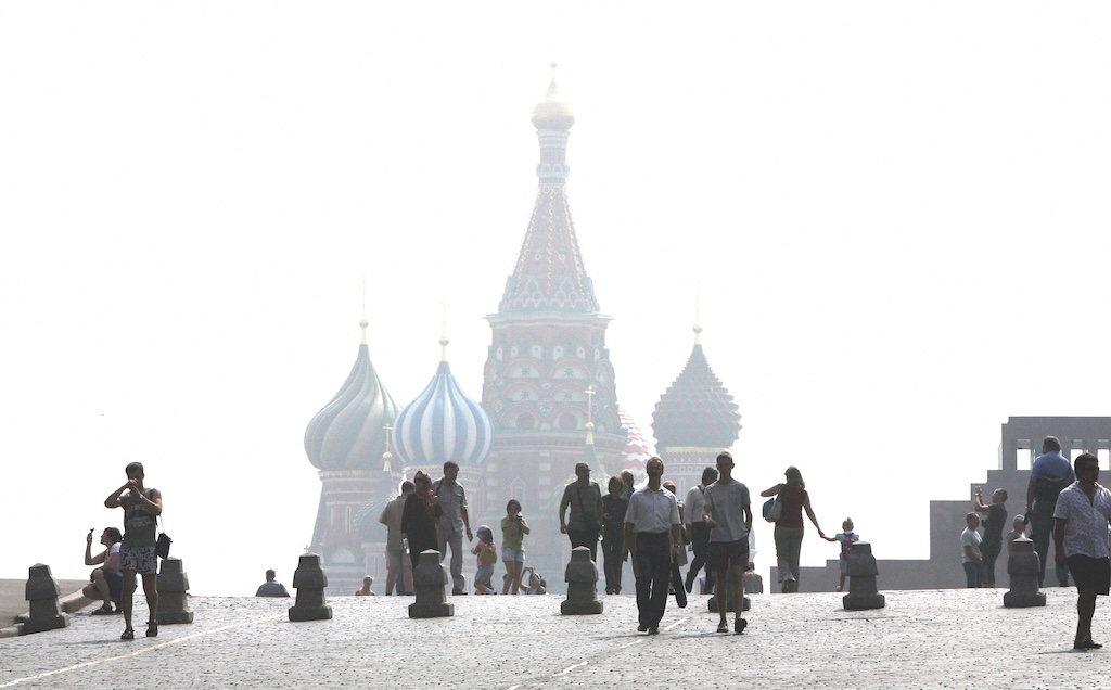
In Russia in the summer of 2010, a compound drought-heatwave event – and the associated wildfires – caused the death of nearly 55,000 people, the study notes.
The record-breaking Pacific north-west “heat dome” in 2021 triggered extreme drought conditions that caused “significant declines” in wheat yields, as well as in barley, canola and fruit production in British Columbia and Alberta, Canada, says the study.
Increasing events
To assess how CDHEs are changing, the researchers use daily reanalysis data to identify droughts and heatwaves events. (Reanalysis data combines past observations with climate models to create a historical climate record.) Then, using an algorithm, they analyse how these events overlap in both time and space.
The study covers the period from 1980 to 2023 and the world’s land surface, excluding polar regions where CDHEs are rare.
The research finds that the area of land affected by CDHEs has “increased substantially” since the early 2000s.
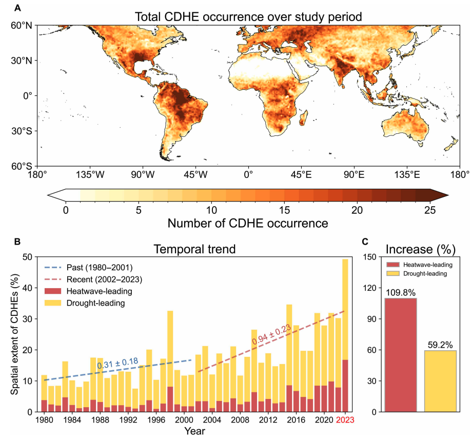
Heatwave-led events have been the main contributor to this increase, the study says, with their spatial extent rising 110% between 1980-2001 and 2002-23, compared to a 59% increase for drought-led events.
The map below shows the global distribution of CDHEs over 1980-2023. The charts show the percentage of the land surface affected by a heatwave-led CDHE (red) or a drought-led CDHE (yellow) in a given year (left) and relative increase in each CDHE type (right).
The study finds that CDHEs have occurred most frequently in northern South America, the southern US, eastern Europe, central Africa and south Asia.
Threshold passed
The authors explain that the increase in heatwave-led CDHEs is related to rising global temperatures, but that this does not tell the whole story.
In the earlier 22-year period of 1980-2001, the study finds that the spatial extent of heatwave-led CDHEs rises by 1.6% per 1C of global temperature rise. For the more-recent period of 2022-23, this increases “nearly eightfold” to 13.1%.
The change suggests that the rapid increase in the heatwave-led CDHEs occurred after the global average temperature “surpasse[d] a certain temperature threshold”, the paper says.
This threshold is an absolute global average temperature of 14.3C, the authors estimate (based on an 11-year average), which the world passed around the year 2000.
Investigating the recent surge in heatwave-leading CDHEs further, the researchers find a “regime shift” in land-atmosphere dynamics “toward a persistently intensified state after the late 1990s”.
In other words, the way that drier soils drive higher surface temperatures, and vice versa, is becoming stronger, resulting in more heatwave-led compound events.
Daily data
The research has some advantages over other previous studies, Yeh says. For instance, the new work uses daily estimations of CDHEs, compared to monthly data used in past research. This is “important for capturing the detailed occurrence” of these events, says Yeh.
He adds that another advantage of their study is that it distinguishes the sequence of droughts and heatwaves, which allows them to “better understand the differences” in the characteristics of CDHEs.
Dr Meryem Tanarhte is a climate scientist at the University Hassan II in Morocco, and Dr Ruth Cerezo Mota is a climatologist and a researcher at the National Autonomous University of Mexico. Both scientists, who were not involved in the study, agree that the daily estimations give a clearer picture of how CDHEs are changing.
Cerezo-Mota adds that another major contribution of the study is its global focus. She tells Carbon Brief that in some regions, such as Mexico and Africa, there is a lack of studies on CDHEs:
“Not because the events do not occur, but perhaps because [these regions] do not have all the data or the expertise to do so.”
However, she notes that the reanalysis data used by the study does have limitations with how it represents rainfall in some parts of the world.
Compound impacts
The study notes that if CDHEs continue to intensify – particularly events where heatwaves are the precursors – they could drive declining crop productivity, increased wildfire frequency and severe public health crises.
These impacts could be “much more rapid and severe as global warming continues”, Yeh tells Carbon Brief.
Tanarhte notes that these events can be forecasted up to 10 days ahead in many regions. Furthermore, she says, the strongest impacts can be prevented “through preparedness and adaptation”, including through “water management for agriculture, heatwave mitigation measures and wildfire mitigation”.
The study recommends reassessing current risk management strategies for these compound events. It also suggests incorporating the sequences of drought and heatwaves into compound event analysis frameworks “to enhance climate risk management”.
Cerezo-Mota says that it is clear that the world needs to be prepared for the increased occurrence of these events. She tells Carbon Brief:
“These [risk assessments and strategies] need to be carried out at the local level to understand the complexities of each region.”



The post Heatwaves driving recent ‘surge’ in compound drought and heat extremes appeared first on Carbon Brief.
Heatwaves driving recent ‘surge’ in compound drought and heat extremes
Greenhouse Gases
DeBriefed 6 March 2026: Iran energy crisis | China climate plan | Bristol’s ‘pioneering’ wind turbine
Welcome to Carbon Brief’s DeBriefed.
An essential guide to the week’s key developments relating to climate change.
This week
Energy crisis
ENERGY SPIKE: US-Israeli attacks on Iran and subsequent counterattacks across the Middle East have sent energy prices “soaring”, according to Reuters. The newswire reported that the region “accounts for just under a third of global oil production and almost a fifth of gas”. The Guardian noted that shipping traffic through the strait of Hormuz, which normally ferries 20% of the world’s oil, “all but ground to a halt”. The Financial Times reported that attacks by Iran on Middle East energy facilities – notably in Qatar – triggered the “biggest rise in gas prices since Russia’s full-scale invasion of Ukraine”.
‘RISK’ AND ‘BENEFITS’: Bloomberg reported on increases in diesel prices in Europe and the US, speculating that rising fuel costs could be “a risk for president Donald Trump”. US gas producers are “poised to benefit from the big disruption in global supply”, according to CNBC. Indian government sources told the Economic Times that Russia is prepared to “fulfil India’s energy demands”. China Daily quoted experts who said “China’s energy security remains fundamentally unshaken”, thanks to “emergency stockpiles and a wide array of import channels”.
‘ESSENTIAL’ RENEWABLES: Energy analysts said governments should cut their fossil-fuel reliance by investing in renewables, “rather than just seeking non-Gulf oil and gas suppliers”, reported Climate Home News. This message was echoed by UK business secretary Peter Kyle, who said “doubling down on renewables” was “essential” amid “regional instability”, according to the Daily Telegraph.
China’s climate plan
PEAK COAL?: China has set out its next “five-year plan” at the annual “two sessions” meeting of the National People’s Congress, including its climate strategy out to 2030, according to the Hong Kong-based South China Morning Post. The plan called for China to cut its carbon emissions per unit of gross domestic product (GDP) by 17% from 2026 to 2030, which “may allow for continued increase in emissions given the rate of GDP growth”, reported Reuters. The newswire added that the plan also had targets to reach peak coal in the next five years and replace 30m tonnes per year of coal with renewables.
ACTIVE YET PRUDENT: Bloomberg described the new plan as “cautious”, stating that it “frustrat[es] hopes for tighter policy that would drive the nation to peak carbon emissions well before president Xi Jinping’s 2030 deadline”. Carbon Brief has just published an in-depth analysis of the plan.