

I have had the privilege to sail twice on the JOIDES Resolution, with this being my second cruise, Expedition 402 Tyrrhenian Continent-Ocean Transition. The first time was with Expedition 393: South Atlantic Transect II. We aimed to study the age of the oceanic crust as we moved away from the mid-Atlantic ridge toward South America. You can see the expedition summary here.

At the time I had very little understanding of rocks and sediment besides what my oceanography class in college provided me. Most of my academic career was focused on the biology of organisms, so when I thought of rocks I thought of how they provided shelter and structure for the living things that I studied. For instance, rocks provided a hard surface for corals and algae to root themselves and sediment provided hiding spots for bottom dwelling fish. After a few days on Expedition 393, I learned that rocks and sediment can hold the history of our atmosphere, the history of our oceans, and the history of catastrophic events (big or small).
The rocks and sediment on both expeditions have been extraordinarily different. I cannot say that I have seen a similar core between the two, which makes sense because we are in drastically different areas. But again, I had the genuine thought, what could be different about the seafloor from one place to another.

Each expedition has different goals, and different operation expectations, however the methods we use to drill, make thin sections, make p-wave velocity measurements, and more tends to be relatively the same give or take some modifications. For example, thin sections can only be done by taking a small piece of hard rock, cut a thing slice from the top, then polish it down to the thickness of a hair strand. That process does not change because we found a rock in a different ocean. As someone who was returning to the JOIDES Resolution, I envisioned seeing similar gray rocks with some dark grays and browns, I envisioned seeing sediment that followed the color range of chocolates in a chocolatier shop. I figured I was going to be learning about the ocean floor from a different perspective guided by the different expedition objectives. Immediately, I was very wrong and it was thrilling. As Phillipe Pezard, our Downhole specialist, said on one of our first days: “I am a kid in a candy shop”. The ship is a candy shop and the scientists are the local kids who just got their weekly allowance.
Sediment in the Tyrrhenian Sea did not look the same as that of in the South Atlantic, nor did it seem to act the same way when we drilled into the seafloor in both locations.

As someone who does not immerse themselves in geology every day, I still was able to follow the science party as they explained their research goals and expectations from the scientific prospectus in the weeks leading up to expedition 402. Rationally it felt straightforward to understand that under different circumstances like temperature and pressure sediment and rocks react in certain ways. It felt straightforward to understand that these materials will undergo change, erosion, weathering, layering and more. But once I saw the actual cores a foot away from my face, it was a whole other beast. That is the value of field work and that is the value of this ship. You cannot learn more about this planet if you do not have access to it.


As I reflected on my two expedition experiences and saw the science crew experience a range of emotions as new cores were collected, I decided to go around and ask some people who have been on multiple expeditions for their perspectives.
“What has surprised you about the rocks and sediment you have seen across expeditions?”
Alejandro has sailed on 8 expeditions (or 6, he wasn’t entirely sure) and is sailing as the Physical Properties Lab Specialist. He is most surprised by the homogeneity (the sameness) and the gradual change in characteristics of the cores from the bigger oceans. When he was in the Pacific it took a few cores before you started to see a huge color change or texture change, while in the shallower basins the cores tend to be more heterogenous (varied) and have more rapid changes to their features. It always keeps him asking why.

Emily Estes has sailed on 4 expeditions with the JOIDES Resolution and is the current Expedition Project Manager. She is surprised that even when we have the prospectus identifying everything that we expect and understand to be in the area, we still find something different. Especially when the data in the prospectus is based on previous drilling sites in the area, one would think the core would bring few surprises. Though she does not think of these moments as bad surprises, but as opportunities to ask more questions. Most of her work and expeditions have been in larger oceanic basins where there are similar features throughout multiple cores before it starts to change, which is not the case for the shallower basins like the Tyrrhenian Sea.

Kevin Grigar has sailed on 24 expeditions and is the Operations Superintendent. Though his role is to check how well the cores are coming out to help determine with SIEM Offshore what could change about the drilling operations and procedures, he still gives the cores a look. What surprises him is the change in formations and color throughout the cores, sometimes within the same core and sometimes it is after a few ones. Either way he is amazed, and loves how pretty the changes can look.

James Kowalski has sailed on 3 expeditions and is sailing as the ship curator. He is surprised by the laminations (layering that happens in sedimentary rocks) and features that disappear quickly between cores. He finds that each core is so different and rarely sees similarity across expeditions. The variety is something that he enjoys and it keeps him on his toes.

Hearing their responses made me think of the cycle of scientific thinking (https://www.youtube.com/watch?v=j12BBcKSgEQ) and what one of our co-chiefs, Nevio Zitellini, said the other day “We start this expedition with a question, and we end this expedition with more questions.”
As we settle into week 3 of Expedition 402, I enter it even more consumed by two notions. First, that we still have so much to learn, and secondly, it seems that when I ask “how could rocks and sediment from one ocean to another be different” it is a question that scientists and the public, alike, share.


Our ocean is an incredibly vast and mysterious place. And there is no place where that is more evident than the deepest ocean area in the world: the legendary Mariana Trench. Located east of the Philippines, the Mariana Trench lies in the Mariana Archipelago in the western portion of the North Pacific. The greater area of the Mariana Trench Marine National Monument is made up of more than 95,000 square miles of ocean. Beneath these waters lie incredibly complex aggregations of submerged islands and volcanoes … and of course, an astoundingly massive trench.
Dive in with us to have your biggest questions answered about the famed Mariana Trench.
How deep is the Mariana Trench?
The deepest part of the Mariana Trench, known as Challenger Deep, is almost 36,000 feet below the ocean’s surface. For context, Mount Everest is about 29,000 feet above sea level, so the Mariana Trench is about 7,000 feet deeper than Mount Everest is tall. For one more comparison, the RMS Titanic lies at a depth of about 12,500 feet below sea level. The Challenger Deep is in waters nearly three times deeper than this ship’s final resting place.
Due to its enormous size, the Mariana Trench has at times been affectionately nicknamed the Grand Canyon of the ocean. This is certainly a picturesque image, but don’t let the mammoth size of this U.S. national terrestrial park fool you into thinking the Mariana Trench matches its size. The trench’s footprint is estimated to be 120 times larger than the Grand Canyon’s, and to reach the bottom of Challenger Deep, you’d need to descend through almost six Grand Canyons stacked on top of each other before you’d reach the seafloor.
Oh … and did we mention it’s five times wider than it is deep? It’s about 43 miles wide!
What is Challenger Deep, and how long would it take to reach it?
Challenger Deep is the deepest point of the Mariana Trench. Fewer than 30 people have ever journeyed to this area. The trek below the surface is long, dark and time-consuming, and it’s not an expedition considered lightly by scientists and explorers.
The first people to descend into the depths of this area in 1960 were oceanographers Jacques Piccard and Don Walsh, and it took them close to five hours to reach Challenger Deep. Since then, more advanced submersibles have been created, but it still takes two to four hours for modern vessels to reach such depths. For example, explorer and filmmaker James Cameron reached the seafloor in a little more than 2.5 hours in the first documented solo submarine dive to the area, and it took oceanographer Dr. Dawn Wright about four hours in 2022. It is crucial that these submersibles descend slowly and steadily beneath the surface, as the immense water pressure compounds with every mile a submersible descends. Speaking of pressure …
Get Ocean Updates in Your Inbox
Sign up with your email and never miss an update.
What is the water pressure at the bottom of the Mariana Trench?
If you thought the depth of the Mariana Trench was its only jaw-dropping feature, think again. Water pressure is one of the most important factors affecting deep-sea life. In the ocean, pressure increases by one atmosphere for every 33 feet (10 meters) of depth. One atmosphere (a unit of measurement for pressure equivalent to average air pressure at sea level) is equal to about 14.7 pounds per square inch (PSI), which is the approximate standard atmospheric pressure at sea level. If you were to convert atmospheric pressure into weight, one atmosphere is about the weight of a bowling ball. Stay with me, friends.
If a vessel were to dive 2,000 feet below the surface, the pressure would equal that of 60 bowling balls stacked atop every square inch of that submersible. But 60 bowling balls is simply nothing compared to the pressure in the Mariana Trench. The atmospheric pressure at the depths of Challenger Deep is equal to about 16,000 PSI. That pressure is about the same as the weight of an entire full-grown elephant on every square inch of a submersible!
Need a more extreme comparison? If a human were to be placed at the bottom of the Mariana Trench, the pressure would be equal to that of 50 jumbo jets piled on top of a person!
Do any animals live in the Mariana Trench?
The depths of the Mariana Trench come with immense pressure and extreme darkness, but somehow, life finds a way to survive. Organisms that live at an extreme depth, like that of Challenger Deep, have to be highly adapted to low temperatures (typically just above freezing), high pressure and virtually no light at all.
Species found in the depths of the Mariana Trench might look vastly different from animals from other ocean depths because their anatomy has been refined to thrive in harsh conditions. At such great depths, these animals typically depend on chemosynthesis (using nutrient-rich waters being pumped out of hydrothermal vents) or descending detritus (dead matter that has fallen from higher parts of the ocean) for food, such as whale falls. Just a handful of these animals include species of octopuses and squids, sea cucumbers, amphipods, sea jellies, shrimp, sea worms and some wild-looking fish!
In 2025, more than 7,000 new species were discovered in the Mariana Trench, including the hadal snailfish (Pseudoliparis swirei). This is the deepest-dwelling fish currently known to science. Now, the fish has been dubbed “the Mariana snailfish.”
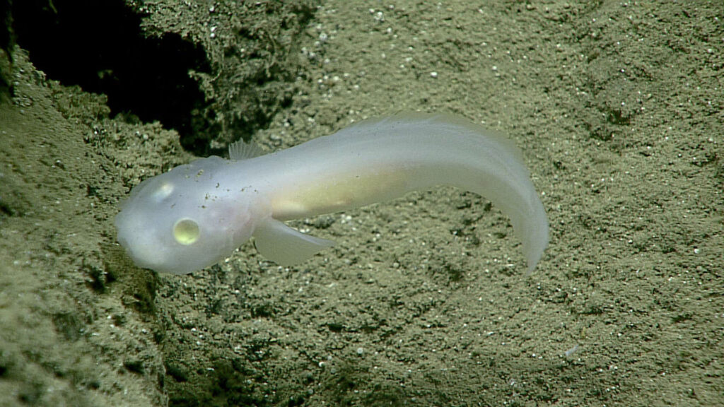
How was the Mariana Trench formed?
The process by which the Mariana Trench was created is a geologically fascinating one known as subduction. On the Earth’s surface, there are thin plates that cover the planet’s mantle, which is made of molten rock. If two of these plates collide, one pushes down into the Earth’s mantle while the other is pushed over the bottom plate. When this happens, a trench is formed from the drag of the bottom plate. This process can sometimes create incredibly strong earthquakes. The plates that forged the Mariana Trench’s creation are estimated to be up to approximately 180 million years old.
This trench was unknown to scientists until 1875. It was then that a team of explorers on the HMS Challenger measured the depth of the sea by simply lowering a weighted rope into the water. They were baffled when they measured that first portion of the seafloor to be five miles below the surface. And so was born the origin of some of the most daring deep-sea explorations known to mankind to date.
Is the Mariana Trench protected?
The Mariana Trench is in waters off Guam and the Mariana Islands. The region is protected from some human activities under its status as a marine monument. The creation of the Mariana Trench Marine National Monument signified that international, national and local leaders all recognize the importance of protecting this area.
However, just because the region is protected does not mean it’s not vulnerable to modern threats to ocean health. Plastic bags have been spotted in the Mariana Trench during several expeditions, highlighting the far-reaching impact of the marine debris problem. No corner of our ocean is safe from the ever-present threat of plastic pollution. The reality of a changing climate makes the future well-being of wondrous places like the Mariana Trench uncertain. What’s more: More than 70% of the global ocean has yet to be mapped. And what we don’t yet know about, we cannot wisely work to protect.
It’s up to us to work together to defend our ocean, from the sandy shores of our favorite beaches to the deepest, darkest parts of the sea. Together, we can work to protect our ocean as a whole, which ultimately helps protect treasured places like Challenger Deep.