

The “monsoon downpour” that triggered deadly landslides in Kerala’s Wayanad district last month was made 10% heavier by human-caused climate change, a new rapid attribution study says.
The landslides followed an “exceptional spell of monsoon rain” on 30 July. They have killed at least 230 people, with more than one hundred people still missing and rescue operations ongoing.
Analysis by the World Weather Attribution (WWA) service shows the rainfall that hit Wayanad on 30 July was the region’s third-heaviest period on record, surpassing even the extreme rainfall that led to flooding in Kerala in 2018.
The team of 24 researchers from India, Malaysia, US, Sweden, Netherlands and UK find that downpours of this intensity have already become 17% heavier in the last 45 years.
In a world where average global temperatures are 2C above pre-industrial levels, they estimate that extreme single-day bursts of rainfall in Kerala could become a further 4% heavier, potentially leading to even more catastrophic landslides.
The study also looks at other “mixed” factors that may have contributed to the high casualties and Wayanad’s “increased susceptibility” to landslides. These include a 62% loss of forest cover in the district and warnings that “failed to reach many people”.
Slippery slope
Wayanad is a mountainous district in northern Kerala in India’s Western Ghats – a chain of mountains older than the Himalaya that runs parallel to the country’s western coast.
With its high elevation and steep slopes – combined with a tendency to receive “prolonged” rainfall and widespread changes to its natural vegetation – Wayanad is highly landslide-prone. It is the most susceptible district to landslides in Kerala, which accounted for 59% of the country’s landslides over 2015-22.

From 22 June onwards, Wayanad saw “nearly continuous” monsoon rainfall, the WWA study says – with some areas recording over 1.8 metres of rain in just a month.
On 30 July, Wayanad witnessed what study author Dr Mariam Zachariah – a research associate at Imperial College’s London’s Grantham Institute for Climate Change – calls “an extreme burst” of more than 140mm of rain in a single day. This is equivalent to nearly a quarter of the rain London receives all year. This rain landed on loose, erodible soils already saturated by two months of monsoon rains.
The first landslide that began at an altitude of 1,550 metres struck the village of Mundakkai at midnight on 30 July, followed by three more landslides within three hours, hitting the villages of Chooralmala and Attamala.
Torrents of mud, water and rock buried several neighbourhoods, swept away victims and collapsed an arterial bridge, delaying rescue operations to the hardest-hit areas.

While state authorities say that the death toll at the time of writing is 231, media reports suggest that the actual number of lives lost to the landslides is greater than 400 – disproportionately impacting migrant workers working in farms, holiday resorts and tea plantations.
In a press briefing, study author Prof Arpita Mondal from the Indian Institute of Technology Bombay said the “scale of the event was so huge that the debris registered a flow of several kilometres”, adding that “body parts have been recovered from downstream rivers as far as tens of kilometres from the location of the landslides”.
The event, she says, was “particularly devastating to two villages – Mundakkai and Chooralmala”, with one official telling News Minute that “I don’t think the Chooralmala ward will exist anymore”.
Monsoon downpour
To put Wayanad’s intense rainfall into its historical context and determine how unlikely it was, the authors analysed a timeseries of one-day maximum rainfall during the June-to-September monsoon season, focusing on northern Kerala.
They find that 140mm of rainfall hit northern Kerala on 30 July 2024, ranking as the third heaviest one-day rainfall event in a record stretching back to 1901.
The intensity of this rainfall surpassed even the “torrential” rainfall that hit large regions of Kerala in 2018, killing more than 40 people and earning the title of Kerala’s “worst floods in nearly a century”.
The map below shows total rainfall on 30 July 2024 in northern Kerala, based on data from the Indian Meteorological Department. Dark blue indicates a high total daily rainfall and yellow indicates a low total. The study region is shown in red on the map.

Total rainfall on 30 July 2024, based on data from the Indian Meteorological Department. Dark blue indicates a high total daily rainfall and yellow indicates a low total. The study region is shown in red. Source: WWA (2024)
The authors find that in today’s climate, this intense one-day rainfall is a one-in-50 year event.
Separately, using satellite observations, the authors find that heavy one-day rainfall events over northern Kerala have become about 17% more intense in the last 45 years, in which time the global climate has warmed by around 0.85C.
Attribution
Attribution is a fast-growing field of climate science that aims to identify the “fingerprint” of climate change on extreme-weather events, such as heatwaves and droughts.
In this study, the authors investigated the impact of climate change specifically on the heavy rainfall in northern Kerala on 30 July 2024.
To conduct attribution studies, scientists use climate models to compare the world as it is today to a “counterfactual” world, without the 1.3C of human-caused warming.
The authors find that climate change made the intense rainfall on 30 July around 10% more intense.
This “may not sound like very much, but really, when you are looking at this amount of rainfall, that is a lot of extra rain”, Dr Claire Barnes, a research associate at Imperial College’s London’s Grantham Institute for Climate Change, and author on the study, told the press briefing.
The authors note that Kerala is a mountainous region with “complex rainfall-climate dynamics” and explain that there is a high level of uncertainty in the model results.
However, Zachariah told the press briefing that the study findings are “consistent with Clausius Clapeyron relationship”, which states that the air can generally hold around 7% more moisture for every 1C of temperature rise.
The authors also investigate how rainfall intensity might change as the planet continues to warm. They find that if the planet were to warm to 2C above pre-industrial temperatures, rainfall intensity in northern Kerala is expected to become a further 4% more intense.
The study says that this increase in rainfall intensity is “likely to increase the potential number of landslides that could be triggered in the future”.
(These findings are yet to be published in a peer-reviewed journal. However, the methods used in the analysis have been published in previous attribution studies.)
Land-use change
The Western Ghats and their high-mountain tropical forest ecosystems are internationally recognised as a biodiversity hotspot and influence Indian monsoon weather patterns.
Wayanad is known for its dense forests and rich biodiversity, but it has also seen significant deforestation and land-use change.
While heavy rainfall was “a trigger” for the devastating landslides, human intervention “has played an important role, there’s no doubt about it”, says Madhavan Rajeevan, India’s former Earth sciences secretary who was not involved in the study. He tells Carbon Brief:
“In many interviews with local people, they say that [large-scale] construction work was going on in the worst-hit areas. And that construction [was done] by removing the local [Indigenous people] staying in the forest. But the landslide doesn’t differentiate between rich and poor. If there was no substantial human intervention in that area for the last four or five years, I’m very sure this landslide would not have happened.”
Between 1950 and 2018, Wayanad lost 62% of its forest cover while land under tea plantations grew by 1,800%, according to one study. The district’s high slopes are also host to coffee, pepper, tea and cardamom plantations, as well as being dotted by luxury resorts.
At the same time, a rise in construction and quarrying for building stones in recent years has “raise[d] concerns” among scientists about the impacts on the stability of hill slopes in the area.
On 31 July, the day after disaster struck, India’s climate ministry issued the sixth draft of a notification to classify parts of the Western Ghats as ecologically sensitive areas (ESAs), 14 years after experts had recommended curbs on development in the region.
Environmental lawyer Shibani Ghosh tells Carbon Brief that, to date, 72,000 square kilometres of the Western Ghats identified by these experts “do not even fall within the ambit of any proposed conservation scheme”.
While environmentalists still have “serious apprehensions” about the area that will be excluded from the Western Ghats ESA in the new draft, “had it been declared [even in its unsatisfactory form] by now, environmentally harmful activities would have been regulated, and perhaps the impact of these natural calamities would have been much less”, she adds.
Rajeevan, additionally, points to how the monsoon has changed in Kerala. He says:
“We know that seasonal rainfall is very high in the west coast, it rains continuously for many days and many hours, but the amount used to be very small: in millimetres per hour. But recent studies are suggesting that these shallow clouds are changing into deep convective clouds that drop very heavy rain in a very short spell, and that could be attributed to warming over the Arabian Sea.”
At the same time, forecasting is another issue that the study raises, drawing attention to the fact that warnings failed to reach many and impacts were not specifically spelt out.

In the aftermath of the landslides, whether meteorological authorities warned of heavy rains became the subject of parliamentary debate. But Rajeevan points out that accurate rain warnings alone are not enough:
“Red alerts and yellow alerts for the whole state or a few districts do not translate into a landslide warning. A district collector cannot translate them or take a decision. The Geological Survey of India issued a warning, but it was not alarming and a sophisticated, real-time landslide alert system needs a lot of money.
“The best solution is to identify and rehabilitate people living in landslide prone areas and to not trouble them by removing their forests.”


The post Climate change made ‘monsoon downpour’ behind Kerala landslides 10% more intense appeared first on Carbon Brief.
Climate change made ‘monsoon downpour’ behind Kerala landslides 10% more intense

Drought and heatwaves occurring together – known as “compound” events – have “surged” across the world since the early 2000s, a new study shows.
Compound drought and heat events (CDHEs) can have devastating effects, creating the ideal conditions for intense wildfires, such as Australia’s “Black Summer” of 2019-20 where bushfires burned 24m hectares and killed 33 people.
The research, published in Science Advances, finds that the increase in CDHEs is predominantly being driven by events that start with a heatwave.
The global area affected by such “heatwave-led” compound events has more than doubled between 1980-2001 and 2002-23, the study says.
The rapid increase in these events over the last 23 years cannot be explained solely by global warming, the authors note.
Since the late 1990s, feedbacks between the land and the atmosphere have become stronger, making heatwaves more likely to trigger drought conditions, they explain.
One of the study authors tells Carbon Brief that societies must pay greater attention to compound events, which can “cause severe impacts on ecosystems, agriculture and society”.
Compound events
CDHEs are extreme weather events where drought and heatwave conditions occur simultaneously – or shortly after each other – in the same region.
These events are often triggered by large-scale weather patterns, such as “blocking” highs, which can produce “prolonged” hot and dry conditions, according to the study.
Prof Sang-Wook Yeh is one of the study authors and a professor at the Ewha Womans University in South Korea. He tells Carbon Brief:
“When heatwaves and droughts occur together, the two hazards reinforce each other through land-atmosphere interactions. This amplifies surface heating and soil moisture deficits, making compound events more intense and damaging than single hazards.”
CDHEs can begin with either a heatwave or a drought.
The sequence of these extremes is important, the study says, as they have different drivers and impacts.
For example, in a CDHE where the heatwave was the precursor, increased direct sunshine causes more moisture loss from soils and plants, leading to a drought.
Conversely, in an event where the drought was the precursor, the lack of soil moisture means that less of the sun’s energy goes into evaporation and more goes into warming the Earth’s surface. This produces favourable conditions for heatwaves.
The study shows that the majority of CDHEs globally start out as a drought.
In recent years, there has been increasing focus on these events due to the devastating impact they have on agriculture, ecosystems and public health.
In Russia in the summer of 2010, a compound drought-heatwave event – and the associated wildfires – caused the death of nearly 55,000 people, the study notes.

The record-breaking Pacific north-west “heat dome” in 2021 triggered extreme drought conditions that caused “significant declines” in wheat yields, as well as in barley, canola and fruit production in British Columbia and Alberta, Canada, says the study.
Increasing events
To assess how CDHEs are changing, the researchers use daily reanalysis data to identify droughts and heatwaves events. (Reanalysis data combines past observations with climate models to create a historical climate record.) Then, using an algorithm, they analyse how these events overlap in both time and space.
The study covers the period from 1980 to 2023 and the world’s land surface, excluding polar regions where CDHEs are rare.
The research finds that the area of land affected by CDHEs has “increased substantially” since the early 2000s.
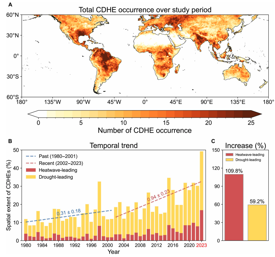
Heatwave-led events have been the main contributor to this increase, the study says, with their spatial extent rising 110% between 1980-2001 and 2002-23, compared to a 59% increase for drought-led events.
The map below shows the global distribution of CDHEs over 1980-2023. The charts show the percentage of the land surface affected by a heatwave-led CDHE (red) or a drought-led CDHE (yellow) in a given year (left) and relative increase in each CDHE type (right).
The study finds that CDHEs have occurred most frequently in northern South America, the southern US, eastern Europe, central Africa and south Asia.
Threshold passed
The authors explain that the increase in heatwave-led CDHEs is related to rising global temperatures, but that this does not tell the whole story.
In the earlier 22-year period of 1980-2001, the study finds that the spatial extent of heatwave-led CDHEs rises by 1.6% per 1C of global temperature rise. For the more-recent period of 2022-23, this increases “nearly eightfold” to 13.1%.
The change suggests that the rapid increase in the heatwave-led CDHEs occurred after the global average temperature “surpasse[d] a certain temperature threshold”, the paper says.
This threshold is an absolute global average temperature of 14.3C, the authors estimate (based on an 11-year average), which the world passed around the year 2000.
Investigating the recent surge in heatwave-leading CDHEs further, the researchers find a “regime shift” in land-atmosphere dynamics “toward a persistently intensified state after the late 1990s”.
In other words, the way that drier soils drive higher surface temperatures, and vice versa, is becoming stronger, resulting in more heatwave-led compound events.
Daily data
The research has some advantages over other previous studies, Yeh says. For instance, the new work uses daily estimations of CDHEs, compared to monthly data used in past research. This is “important for capturing the detailed occurrence” of these events, says Yeh.
He adds that another advantage of their study is that it distinguishes the sequence of droughts and heatwaves, which allows them to “better understand the differences” in the characteristics of CDHEs.
Dr Meryem Tanarhte is a climate scientist at the University Hassan II in Morocco, and Dr Ruth Cerezo Mota is a climatologist and a researcher at the National Autonomous University of Mexico. Both scientists, who were not involved in the study, agree that the daily estimations give a clearer picture of how CDHEs are changing.
Cerezo-Mota adds that another major contribution of the study is its global focus. She tells Carbon Brief that in some regions, such as Mexico and Africa, there is a lack of studies on CDHEs:
“Not because the events do not occur, but perhaps because [these regions] do not have all the data or the expertise to do so.”
However, she notes that the reanalysis data used by the study does have limitations with how it represents rainfall in some parts of the world.
Compound impacts
The study notes that if CDHEs continue to intensify – particularly events where heatwaves are the precursors – they could drive declining crop productivity, increased wildfire frequency and severe public health crises.
These impacts could be “much more rapid and severe as global warming continues”, Yeh tells Carbon Brief.
Tanarhte notes that these events can be forecasted up to 10 days ahead in many regions. Furthermore, she says, the strongest impacts can be prevented “through preparedness and adaptation”, including through “water management for agriculture, heatwave mitigation measures and wildfire mitigation”.
The study recommends reassessing current risk management strategies for these compound events. It also suggests incorporating the sequences of drought and heatwaves into compound event analysis frameworks “to enhance climate risk management”.
Cerezo-Mota says that it is clear that the world needs to be prepared for the increased occurrence of these events. She tells Carbon Brief:
“These [risk assessments and strategies] need to be carried out at the local level to understand the complexities of each region.”




The post Heatwaves driving recent ‘surge’ in compound drought and heat extremes appeared first on Carbon Brief.
Heatwaves driving recent ‘surge’ in compound drought and heat extremes
Greenhouse Gases
DeBriefed 6 March 2026: Iran energy crisis | China climate plan | Bristol’s ‘pioneering’ wind turbine
Welcome to Carbon Brief’s DeBriefed.
An essential guide to the week’s key developments relating to climate change.
This week
Energy crisis
ENERGY SPIKE: US-Israeli attacks on Iran and subsequent counterattacks across the Middle East have sent energy prices “soaring”, according to Reuters. The newswire reported that the region “accounts for just under a third of global oil production and almost a fifth of gas”. The Guardian noted that shipping traffic through the strait of Hormuz, which normally ferries 20% of the world’s oil, “all but ground to a halt”. The Financial Times reported that attacks by Iran on Middle East energy facilities – notably in Qatar – triggered the “biggest rise in gas prices since Russia’s full-scale invasion of Ukraine”.
‘RISK’ AND ‘BENEFITS’: Bloomberg reported on increases in diesel prices in Europe and the US, speculating that rising fuel costs could be “a risk for president Donald Trump”. US gas producers are “poised to benefit from the big disruption in global supply”, according to CNBC. Indian government sources told the Economic Times that Russia is prepared to “fulfil India’s energy demands”. China Daily quoted experts who said “China’s energy security remains fundamentally unshaken”, thanks to “emergency stockpiles and a wide array of import channels”.
‘ESSENTIAL’ RENEWABLES: Energy analysts said governments should cut their fossil-fuel reliance by investing in renewables, “rather than just seeking non-Gulf oil and gas suppliers”, reported Climate Home News. This message was echoed by UK business secretary Peter Kyle, who said “doubling down on renewables” was “essential” amid “regional instability”, according to the Daily Telegraph.
China’s climate plan
PEAK COAL?: China has set out its next “five-year plan” at the annual “two sessions” meeting of the National People’s Congress, including its climate strategy out to 2030, according to the Hong Kong-based South China Morning Post. The plan called for China to cut its carbon emissions per unit of gross domestic product (GDP) by 17% from 2026 to 2030, which “may allow for continued increase in emis