Drought and heatwaves occurring together – known as “compound” events – have “surged” across the world since the early 2000s, a new study shows.
Compound drought and heat events (CDHEs) can have devastating effects, creating the ideal conditions for intense wildfires, such as Australia’s “Black Summer” of 2019-20 where bushfires burned 24m hectares and killed 33 people.
The research, published in Science Advances, finds that the increase in CDHEs is predominantly being driven by events that start with a heatwave.
The global area affected by such “heatwave-led” compound events has more than doubled between 1980-2001 and 2002-23, the study says.
The rapid increase in these events over the last 23 years cannot be explained solely by global warming, the authors note.
Since the late 1990s, feedbacks between the land and the atmosphere have become stronger, making heatwaves more likely to trigger drought conditions, they explain.
One of the study authors tells Carbon Brief that societies must pay greater attention to compound events, which can “cause severe impacts on ecosystems, agriculture and society”.
Compound events
CDHEs are extreme weather events where drought and heatwave conditions occur simultaneously – or shortly after each other – in the same region.
These events are often triggered by large-scale weather patterns, such as “blocking” highs, which can produce “prolonged” hot and dry conditions, according to the study.
Prof Sang-Wook Yeh is one of the study authors and a professor at the Ewha Womans University in South Korea. He tells Carbon Brief:
“When heatwaves and droughts occur together, the two hazards reinforce each other through land-atmosphere interactions. This amplifies surface heating and soil moisture deficits, making compound events more intense and damaging than single hazards.”
CDHEs can begin with either a heatwave or a drought.
The sequence of these extremes is important, the study says, as they have different drivers and impacts.
For example, in a CDHE where the heatwave was the precursor, increased direct sunshine causes more moisture loss from soils and plants, leading to a drought.
Conversely, in an event where the drought was the precursor, the lack of soil moisture means that less of the sun’s energy goes into evaporation and more goes into warming the Earth’s surface. This produces favourable conditions for heatwaves.
The study shows that the majority of CDHEs globally start out as a drought.
In recent years, there has been increasing focus on these events due to the devastating impact they have on agriculture, ecosystems and public health.
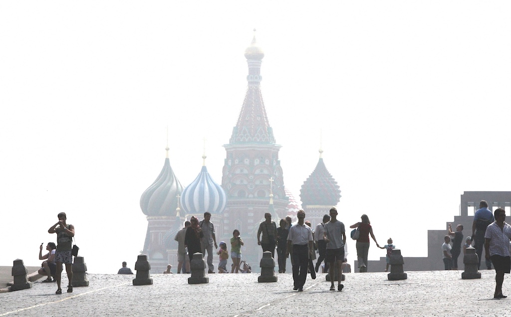
In Russia in the summer of 2010, a compound drought-heatwave event – and the associated wildfires – caused the death of nearly 55,000 people, the study notes.
The record-breaking Pacific north-west “heat dome” in 2021 triggered extreme drought conditions that caused “significant declines” in wheat yields, as well as in barley, canola and fruit production in British Columbia and Alberta, Canada, says the study.
Increasing events
To assess how CDHEs are changing, the researchers use daily reanalysis data to identify droughts and heatwaves events. (Reanalysis data combines past observations with climate models to create a historical climate record.) Then, using an algorithm, they analyse how these events overlap in both time and space.
The study covers the period from 1980 to 2023 and the world’s land surface, excluding polar regions where CDHEs are rare.
The research finds that the area of land affected by CDHEs has “increased substantially” since the early 2000s.
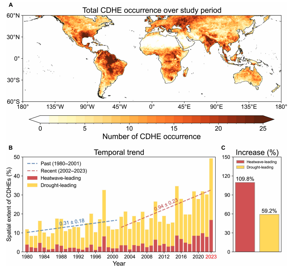
Heatwave-led events have been the main contributor to this increase, the study says, with their spatial extent rising 110% between 1980-2001 and 2002-23, compared to a 59% increase for drought-led events.
The map below shows the global distribution of CDHEs over 1980-2023. The charts show the percentage of the land surface affected by a heatwave-led CDHE (red) or a drought-led CDHE (yellow) in a given year (left) and relative increase in each CDHE type (right).
The study finds that CDHEs have occurred most frequently in northern South America, the southern US, eastern Europe, central Africa and south Asia.
Threshold passed
The authors explain that the increase in heatwave-led CDHEs is related to rising global temperatures, but that this does not tell the whole story.
In the earlier 22-year period of 1980-2001, the study finds that the spatial extent of heatwave-led CDHEs rises by 1.6% per 1C of global temperature rise. For the more-recent period of 2022-23, this increases “nearly eightfold” to 13.1%.
The change suggests that the rapid increase in the heatwave-led CDHEs occurred after the global average temperature “surpasse[d] a certain temperature threshold”, the paper says.
This threshold is an absolute global average temperature of 14.3C, the authors estimate (based on an 11-year average), which the world passed around the year 2000.
Investigating the recent surge in heatwave-leading CDHEs further, the researchers find a “regime shift” in land-atmosphere dynamics “toward a persistently intensified state after the late 1990s”.
In other words, the way that drier soils drive higher surface temperatures, and vice versa, is becoming stronger, resulting in more heatwave-led compound events.
Daily data
The research has some advantages over other previous studies, Yeh says. For instance, the new work uses daily estimations of CDHEs, compared to monthly data used in past research. This is “important for capturing the detailed occurrence” of these events, says Yeh.
He adds that another advantage of their study is that it distinguishes the sequence of droughts and heatwaves, which allows them to “better understand the differences” in the characteristics of CDHEs.
Dr Meryem Tanarhte is a climate scientist at the University Hassan II in Morocco, and Dr Ruth Cerezo Mota is a climatologist and a researcher at the National Autonomous University of Mexico. Both scientists, who were not involved in the study, agree that the daily estimations give a clearer picture of how CDHEs are changing.
Cerezo-Mota adds that another major contribution of the study is its global focus. She tells Carbon Brief that in some regions, such as Mexico and Africa, there is a lack of studies on CDHEs:
“Not because the events do not occur, but perhaps because [these regions] do not have all the data or the expertise to do so.”
However, she notes that the reanalysis data used by the study does have limitations with how it represents rainfall in some parts of the world.
Compound impacts
The study notes that if CDHEs continue to intensify – particularly events where heatwaves are the precursors – they could drive declining crop productivity, increased wildfire frequency and severe public health crises.
These impacts could be “much more rapid and severe as global warming continues”, Yeh tells Carbon Brief.
Tanarhte notes that these events can be forecasted up to 10 days ahead in many regions. Furthermore, she says, the strongest impacts can be prevented “through preparedness and adaptation”, including through “water management for agriculture, heatwave mitigation measures and wildfire mitigation”.
The study recommends reassessing current risk management strategies for these compound events. It also suggests incorporating the sequences of drought and heatwaves into compound event analysis frameworks “to enhance climate risk management”.
Cerezo-Mota says that it is clear that the world needs to be prepared for the increased occurrence of these events. She tells Carbon Brief:
“These [risk assessments and strategies] need to be carried out at the local level to understand the complexities of each region.”

The post Heatwaves driving recent ‘surge’ in compound drought and heat extremes appeared first on Carbon Brief.
Heatwaves driving recent ‘surge’ in compound drought and heat extremes
Climate Change
Woodside’s own modelling reveals catastrophic oil spill risk at Scott Reef
What if Australia’s worst offshore oil spill hasn’t happened yet?
I’m terrified by the thought.
Our new report in partnership with Environs Kimberley analyses Woodside’s own oil spill modelling and it reveals a worst-case blowout at the corporation’s proposed Browse gas project at Scott Reef could be up to 30 times larger than the Montara oil spill – one of Australia’s worst environmental disasters to date.
Woodside’s own modelling warns that oil pollution could spread across Scott Reef, the Kimberley coast and beyond, with impacts Woodside itself describes as “severe”, “potentially irreversible” and “catastrophic”.

What’s at stake?
Scott Reef really is like nowhere else on Earth.
Scott Reef is Australia’s largest freestanding oceanic reef, a pristine marine ecosystem that has thrived for around 15 million years. About 270 kilometres off the Kimberley coast, it supports more than 2,000 marine species, including endangered pygmy blue whales, nesting green sea turtles, the endangered dusky sea snake and ancient corals.
Yet Woodside wants to drill up to 57 toxic wells around and underneath it, causing decades of deafening seismic blasting, light and noise pollution, shipping traffic and, of course, the risk of a ‘catastrophic’ oil spill.

What did Woodside’s modelling find?
Before Browse can be approved, Woodside is required to assess what could happen if something goes wrong. We analysed the corporation’s own environmental assessment documents, and the findings are deeply concerning.
Woodside’s modelling shows that the most severe Browse scenario would be the worst oil spill in Australian history, releasing up to 893,739 barrels of condensate into the Timor Sea. For context, the Montara oil spill released 30,000 barrels of oil.
A blowout of this scale could see oil spread hundreds of kilometres, reaching some of Australia’s most important marine environments, extending into Indonesian and Timor-Leste waters and even washing up along parts of the Kimberley coast. Entrained oil – oil mixed throughout the water column – is predicted to travel up to 863 kilometres from the spill site.
The modelling identifies potential impacts to at least nine marine parks, eight reefs and three Indigenous Protected Areas, as well as important habitats for endangered species, including pygmy blue whales, green sea turtles, seabirds and other marine life.

These aren’t just places on a map. They are globally significant marine ecosystems that support ancient coral reefs, endangered wildlife, tourism, fisheries and coastal communities. A spill of this scale wouldn’t simply affect one reef; it has the potential to impact an entire connected marine ecosystem.
Why this matters now
The most important thing is that Browse has not yet been approved. That means there is still time to stop Browse and the serious risks outlined in Woodside’s own modelling.
The science has been done. The risks have been modelled. The decision now rests with the Australian Government.
Governments are often forced to respond after environmental disasters happen. This is one of those rare moments where they have the opportunity to act before one does.
What you can do
Together, we still have the power to stop Woodside and save Scott Reef.
You can help by:
- Sending an email to Environment Minister Murray Watt and Prime Minister Anthony Albanese, calling on them to reject Browse.
- Sharing this story to help more Australians understand what’s at stake.
- Encouraging your friends and family to take action.
The more people who support saving Scott Reef, the harder it is for governments to approve Woodside’s drilling plans – Browse.
Together, we can ensure a reef that has existed for millions of years is known for its incredible biodiversity – not as the site of Australia’s worst oil spill.
Let’s save Scott Reef.
What if Australia’s worst offshore oil spill hasn’t happened yet?
Climate Change
REPORT: ‘Catastrophic” Browse Oil Spill Report
Analysis by Greenpeace and Environs Kimberley shows that a severe oil spill at Scott Reef could be the worst in Australian history — Woodside has labeled the impact of such a spill ‘catastrophic’.
According to the fossil fuel company the impacts to Scott Reef ‘would likely be severe and potentially irreversible’. Oily pollution could reach as far as the Kimberley coast to the coasts of Indonesia and Timor Leste while endangered marine species live, breed, forage and migrate within the potential disaster zone: whales, seabirds, turtles and other marine life are all at risk.
Report Summary
Woodside’s Browse drilling plans at Scott Reef have been found to pose unacceptable risks to the Western Australian environment once before. To secure their approvals under Federal and Western Australian law, Woodside has modelled a number of possible oil spill scenarios that could result from the Browse project.

Key Findings
- The most severe Browse scenario would be the worst oil spill in Australian history – up to 30 times bigger than the 2009 Montara oil spill disaster. According to Woodside, the environmental impact of such a spill would be ‘catastrophic’.
- Scott Reef and Sandy Islet could be covered in oily pollution. Woodside has conceded that the impacts to Scott Reef from a major spill ‘would likely be severe and potentially irreversible’.
- A blowout of this scale could see oil washing up on the Western Australian Kimberley Coast, and affect at least nine marine parks, eight reefs, three Indigenous Protected Areas, and several islands in Australian, Indonesian and Timor Leste waters.
- Endangered and vulnerable marine species live, breed, forage and migrate within the potential disaster zone: whales, seabirds, turtles and other marine life are all at risk.
- A Browse oil spill threatens important tourism, diving, surfing and fishing hotspots, with potential ‘long term impacts’ for tourism operators in the Kimberley or visiting Rowley Shoals or Scott Reef.

Scott Reef: An ancient oceanic reef system
Scott Reef, located around 270 kilometres off the Western Australian Kimberley coast, is one of Australia’s largest oceanic reef systems. Ancient Scott Reef has been thriving for 15 million years, having adapted to changing seas. Today, it is a haven for marine life, providing vital habitat for more than a thousand species, including corals, fish, sharks and rays.
The deep waters surrounding the reef are home to 29 known species of whale and dolphin, including endangered pygmy blue whales, which travel along the Western Australian coast and stop at Scott Reef during their annual migration to forage and feed. The dusky sea snake, also classified as endangered, lives at Scott Reef. Sandy Islet, part of Scott Reef, is a nesting ground for a small population of genetically distinct green sea turtles, a species classified as vulnerable.
If Woodside, Australia’s largest oil and gas company, were to gain approval to drill for gas at Scott Reef, the ecosystem would face a barrage of industrial impacts, including seismic blasting, gas flaring, underwater noise, artificial lighting, pipe- laying, and fast-moving vessels over years of construction and operation. Add to that the risk of a major oil spill that could be Australia’s worst environmental disaster, with consequences spreading far beyond Scott Reef.

A disaster worse than Montara, according to Woodside itself
Woodside has proposed drilling 50 new wells around Scott Reef to extract oil and gas from beneath the reef as part of the Browse project. Woodside has proposed to build a 900-kilometre-long undersea pipeline to connect the Scott Reef-Browse site with its North West Shelf facility at Karratha in Western Australia, where the gas would be processed, mostly for international export. Woodside has modelled a number of possible oil spill scenarios that could result from the Browse project. Woodside performed this modelling to comply with mandatory environmental impact assessment requirements under Federal and Western Australian laws.
To identify which areas are at risk of an oil spill from the Browse project, Woodside engaged experts to conduct probabilistic modelling. Experts simulated different spills, noting which locations would be contaminated by oil and how much oil would make it to shore. They also assessed how likely each location was to be affected.
” Woodside’s ‘worst case’ scenario is a blowout at the Torosa gasfield, directly under Scott Reef.”
Greenpeace Australia Pacific and Environs Kimberley’s analysis shows an oil spill at Torosa could see 893,739 barrels of condensate spilled into the Timor Sea. This would be up to 30 times bigger than the 2009 Montara oil spill, considered one of Australia’s worst environmental disasters. Oil leaked into the Timor Sea for days after an oil rig caught fire off the Western Australian coast, causing a 90,000 square kilometre oil slick that spread all the way to Indonesia.
People, places and wildlife at risk
Woodside’s modelling shows that an oil spill at Scott Reef could affect eight reefs, at least nine marine parks and three Indigenous Protected Areas. In the event of a worst-case oil spill, Scott Reef and Sandy Islet, being closest to the wellhead, would be worst affected.
Woodside’s modelling finds that the impacts to Scott Reef from a major spill like this ‘would likely be severe and potentially irreversible’. The impacts of an oil spill are not confined to Scott Reef – according to Woodside’s modelling, ‘hydrocarbon spills resulting from the proposed Browse to NWS Project have the potential to significantly impact shoreline habitats at Scott Reef, Ashmore Reef, Cartier Island and Rowley Shoals.’
Oil from a blowout could also reach neighbouring countries, including Pulau Rote, Savu, Sumba and West Timor in Indonesia, and Timor Leste. This is not an exhaustive list of all places that could be affected by an oil spill at Scott Reef. Once oil hits the water, its spread is influenced by the wind, tides, currents and other external conditions. An oil spill from the Browse project could have a less or more severe impact than the modelling indicates. Equally, Woodside cannot rule out other sites being affected.
A disaster for marine life
Woodside’s oil spill modelling shows that a blowout from the Browse project would put whales, turtles, seabirds, coral, significant feedstocks such as plankton and seagrass, fish, dolphins and other marine life at risk. According to Woodside, a Browse oil spill would:
- Directly threaten the coral at Scott Reef, with ‘potential for near total coral mortality in the worst affected areas’; a severe spill could also harm coral at Seringapatam Reef and the Rowley Shoals.
- ‘Significantly impact’ the plankton, seagrass and macroalgae that support the entire food chain.
- ‘Significantly impact bird species, including protected species’, which are ‘particularly vulnerable’ to oil spills.
A spill would not only threaten birds at Scott Reef, but those that nest or breed at Ashmore Reef and Cartier Island, Browse Island, islands along the Kimberley coastline (such as the Lacepede Islands) and Rowley Shoals. Woodside’s oil spill modelling specifically notes the potential risk to thirteen species of seabirds.
Oil spills also threaten whales and other cetaceans, especially concentrations of oil on the surface of the water. This can cause ‘sublethal and lethal effects’, especially when feeding, as whales and other marine mammals have been found to aspirate oil when breathing through an oil slick at the sea surface, thus absorbing hydrocarbons directly into their lungs, leading to sublethal and lethal impacts.
According to Woodside’s modelling, a Browse oil spill could be particularly harmful to the spinner dolphins living at Scott Reef with the potential for ‘a significant portion of this local population to be impacted in the event of a worst-case hydrocarbon spill’.
Marine reptiles, including the green sea turtles found at Scott Reef, are also at risk. Woodside’s modelling warns that an oil spill could cause ‘significant mortality amongst adults and hatchlings’, leading to ‘the potential for longer-term impacts on the Scott Reef – Browse Island genetic stock of green turtles’. Further, an oil spill could have lasting impacts on the breeding populations of olive ridley turtles, flatback turtles and hawksbill turtles. Essentially, all marine life found at or near the sea surface could be impacted by such a spill.

Woodside cannot be trusted
In Woodside’s inadequate response plan, Woodside states that it considers an oil spill to be ‘highly unlikely’ and the threat to the environment and wildlife to be ‘acceptable’. We do not believe these are credible assertions. For instance, the WA Environmental Protection Authority (EPA), which is assessing Woodside’s Browse to NWS proposal, did not agree. In August 2024, it emerged that the EPA advised Woodside that its Browse development posed ‘unacceptable’ risks to WA’s environment.
A potential oil spill from the Torosa field was one of the risks cited by the EPA in its preliminary decision not to approve the project. Woodside has subsequently revised its plans to drill for gas at Scott Reef, proposing to use unproven new technology that the company claims would bring a spill under control more quickly, reducing the spill time from 77 days to 13 days.
However, an independent assessment commissioned by Woodside did not support these claims. Instead, the expert questioned whether the piece of equipment proposed by Woodside — a capping stack — could be deployed in practice, and the time it would likely take to do so.
While Woodside has also claimed that a ‘pyrotechnic shear ram’ would reduce the spill time to as little as 24 hours, the company’s expert noted that this had yet to be ‘used in anger’ and that ‘there remains a risk’ that it fails to function.
Woodside’s alarming track record
Woodside’s stated ability to prevent or control a disaster is undercut by its poor environmental and safety track record. There have been numerous incidents at Woodside’s facilities over the last decade threatening the safety of its workers and the environment. These include:
- Whale calf collision: In August 2023, a tugboat operated by a Woodside contractor hit a whale calf in the Port of Dampier. The incident was only confirmed by the Department of Biodiversity, Conservation and Attractions (DBCA) after media inquiries.
- Explosion at Pluto LNG plant: In May 2023, an explosion forced Woodside to shut down and evacuate its Pluto LNG facility. Woodside was accused by unions of downplaying the incident. Eighteen months later, Woodside was again forced to put Pluto LNG into an emergency shutdown after the control systems failed.
- Oil spill near Ningaloo: In May 2025, Woodside spilled 16,000 litres of ‘hydrocarbons’ into the ocean near World Heritage listed Ningaloo Reef while decommissioning its Griffin facility. Three months later, the government regulator ordered Woodside to stop decommissioning operations at Griffin and nearby Stybarrow following a series of ‘preventable health and safety incidents’ at both sites.
- Oil spill in Cossack field: In 2016, a Woodside oil rig in the Cossack field leaked over 10,500 litres of oil into the ocean due to a degraded seal.
- Northern Endeavour clean-up debacle: Woodside evaded a $362 million decommissioning bill for its Northern Endeavour oil platform in the Timor Sea by offloading it onto a one-person operation. When the buyer went bankrupt, the Federal Government had to step in, eventually putting a levy on offshore oil and gas companies to recover the clean up costs.
- Cost-cutting and corrosion: In 2021, Woodside announced a 30% cut in operating costs, focusing on maintenance, despite repeated warnings from the government regulator about corrosion at its oil and gas facilities. The warnings continued. In July 2023, the regulator blamed Woodside’s ‘inadequate maintenance’ for serious corrosion of the flare bridge and support structure at its North Rankin complex.
- Abandoned infrastructure: Woodside finished extracting oil from the Enfield field in 2018. In 2019, the government regulator ordered Woodside to remove the Nganhurra Riser Turret Mooring (RTM), an 83-metre-long, 2,452 tonne piece of infrastructure. Woodside instead tried to sink the RTM near the World Heritage-listed Ningaloo Reef. After a public outcry, Woodside finally removed the RTM in October 2023.
A lasting legacy for our oceans: Save Scott Reef from Woodside’s pollution
Woodside’s Browse proposal to drill for oil and gas presents unacceptable risks to Scott Reef and the web of life it supports from Western Australia to Indonesia.
Greenpeace Australia Pacific and Environs Kimberley are calling on the WA and Federal Governments to save Scott Reef by rejecting Woodside’s Browse project once and for all.
What you can do
Together, we still have the power to stop Woodside and save Scott Reef.
You can help by:
- Sending an email to Environment Minister Murray Watt and Prime Minister Anthony Albanese, calling on them to reject Browse.
- Sharing this story to help more Australians understand what’s at stake.
- Encouraging your friends and family to take action.
Climate Change
Browse Oil Spill Report

Analysis by Greenpeace and Environs Kimberley shows that a severe oil spill at Scott Reef could be the worst in Australian history — Woodside has labeled the impact of such a spill ‘catastrophic’. According to the fossil fuel company the impacts to Scott Reef ‘would likely be severe and potentially irreversible’. Oily pollution could reach as far as the Kimberley coast to the coasts of Indonesia and Timor Leste while endangered marine species live, breed, forage and migrate within the potential disaster zone: whales, seabirds, turtles and other marine life are all at risk.
Woodside’s Browse drilling plans at Scott Reef have been found to pose unacceptable risks to the Western Australian environment once before. To secure their approvals under Federal and Western Australian law, Woodside has modelled a number of possible oil spill scenarios that could result from the Browse project.

GPAP illustration of a ‘worst case’ senario oil spill based on Woodside’s own modeling.
Key Findings
- The most severe Browse scenario would be the worst oil spill in Australian history – up to 30 times bigger than the 2009 Montara oil spill disaster. According to Woodside, the environmental impact of such a spill would be ‘catastrophic’.
- Scott Reef and Sandy Islet could be covered in oily pollution. Woodside has conceded that the impacts to Scott Reef from a major spill ‘would likely be severe and potentially irreversible’.
- A blowout of this scale could see oil washing up on the Western Australian Kimberley Coast, and affect at least nine marine parks, eight reefs, three Indigenous Protected Areas, and several islands in Australian, Indonesian and Timor Leste waters.
- Endangered and vulnerable marine species live, breed, forage and migrate within the potential disaster zone: whales, seabirds, turtles and other marine life are all at risk.
- A Browse oil spill threatens important tourism, diving, surfing and fishing hotspots, with potential ‘long term impacts’ for tourism operators in the Kimberley or visiting Rowley Shoals or Scott Reef.

Browse and Montara: Location and extent in the Timor Sea: GPAP illustration based on maps from ‘The Montara Oil Spill: A 2009 Well Blowout in the Timor Sea’ and a Browse loss of well containment.
Scott Reef: An ancient oceanic reef system
Scott Reef, located around 270 kilometres off the Western Australian Kimberley coast, is one of Australia’s largest oceanic reef systems. Ancient Scott Reef has been thriving for 15 million years, having adapted to changing seas. Today, it is a haven for marine life, providing vital habitat for more than a thousand species, including corals, fish, sharks and rays.
The deep waters surrounding the reef are home to 29 known species of whale and dolphin, including endangered pygmy blue whales, which travel along the Western Australian coast and stop at Scott Reef during their annual migration to forage and feed. The dusky sea snake, also classified as endangered, lives at Scott Reef. Sandy Islet, part of Scott Reef, is a nesting ground for a small population of genetically distinct green sea turtles, a species classified as vulnerable.
If Woodside, Australia’s largest oil and gas company, were to gain approval to drill for gas at Scott Reef, the ecosystem would face a barrage of industrial impacts, including seismic blasting, gas flaring, underwater noise, artificial lighting, pipe- laying, and fast-moving vessels over years of construction and operation. Add to that the risk of a major oil spill that could be Australia’s worst environmental disaster, with consequences spreading far beyond Scott Reef.

GPAP illustration of drilling sights at Scott Reef.
A disaster worse than Montara, according to Woodside itself
Woodside has proposed drilling 50 new wells around Scott Reef to extract oil and gas from beneath the reef as part of the Browse project. Woodside has proposed to build a 900-kilometre-long undersea pipeline to connect the Scott Reef-Browse site with its North West Shelf facility at Karratha in Western Australia, where the gas would be processed, mostly for international export. Woodside has modelled a number of possible oil spill scenarios that could result from the Browse project. Woodside performed this modelling to comply with mandatory environmental impact assessment requirements under Federal and Western Australian laws.
To identify which areas are at risk of an oil spill from the Browse project, Woodside engaged experts to conduct probabilistic modelling. Experts simulated different spills, noting which locations would be contaminated by oil and how much oil would make it to shore. They also assessed how likely each location was to be affected.
” Woodside’s ‘worst case’ scenario is a blowout at the Torosa gasfield, directly under Scott Reef.”
Greenpeace Australia Pacific and Environs Kimberley’s analysis shows an oil spill at Torosa could see 893,739 barrels of condensate spilled into the Timor Sea. This would be up to 30 times bigger than the 2009 Montara oil spill, considered one of Australia’s worst environmental disasters. Oil leaked into the Timor Sea for days after an oil rig caught fire off the Western Australian coast, causing a 90,000 square kilometre oil slick that spread all the way to Indonesia.
People, places and wildlife at risk
Woodside’s modelling shows that an oil spill at Scott Reef could affect eight reefs, at least nine marine parks and three Indigenous Protected Areas. In the event of a worst-case oil spill, Scott Reef and Sandy Islet, being closest to the wellhead, would be worst affected.
Woodside’s modelling finds that the impacts to Scott Reef from a major spill like this ‘would likely be severe and potentially irreversible’. The impacts of an oil spill are not confined to Scott Reef – according to Woodside’s modelling, ‘hydrocarbon spills resulting from the proposed Browse to NWS Project have the potential to significantly impact shoreline habitats at Scott Reef, Ashmore Reef, Cartier Island and Rowley Shoals.’
Oil from a blowout could also reach neighbouring countries, including Pulau Rote, Savu, Sumba and West Timor in Indonesia, and Timor Leste. This is not an exhaustive list of all places that could be affected by an oil spill at Scott Reef. Once oil hits the water, its spread is influenced by the wind, tides, currents and other external conditions. An oil spill from the Browse project could have a less or more severe impact than the modelling indicates. Equally, Woodside cannot rule out other sites being affected.
A disaster for marine life
Woodside’s oil spill modelling shows that a blowout from the Browse project would put whales, turtles, seabirds, coral, significant feedstocks such as plankton and seagrass, fish, dolphins and other marine life at risk. According to Woodside, a Browse oil spill would:
- Directly threaten the coral at Scott Reef, with ‘potential for near total coral mortality in the worst affected areas’; a severe spill could also harm coral at Seringapatam Reef and the Rowley Shoals.
- ‘Significantly impact’ the plankton, seagrass and macroalgae that support the entire food chain.
- ‘Significantly impact bird species, including protected species’, which are ‘particularly vulnerable’ to oil spills.
A spill would not only threaten birds at Scott Reef, but those that nest or breed at Ashmore Reef and Cartier Island, Browse Island, islands along the Kimberley coastline (such as the Lacepede Islands) and Rowley Shoals. Woodside’s oil spill modelling specifically notes the potential risk to thirteen species of seabirds.
Oil spills also threaten whales and other cetaceans, especially concentrations of oil on the surface of the water. This can cause ‘sublethal and lethal effects’, especially when feeding, as whales and other marine mammals have been found to aspirate oil when breathing through an oil slick at the sea surface, thus absorbing hydrocarbons directly into their lungs, leading to sublethal and lethal impacts.
According to Woodside’s modelling, a Browse oil spill could be particularly harmful to the spinner dolphins living at Scott Reef with the potential for ‘a significant portion of this local population to be impacted in the event of a worst-case hydrocarbon spill’.
Marine reptiles, including the green sea turtles found at Scott Reef, are also at risk. Woodside’s modelling warns that an oil spill could cause ‘significant mortality amongst adults and hatchlings’, leading to ‘the potential for longer-term impacts on the Scott Reef – Browse Island genetic stock of green turtles’. Further, an oil spill could have lasting impacts on the breeding populations of olive ridley turtles, flatback turtles and hawksbill turtles. Essentially, all marine life found at or near the sea surface could be impacted by such a spill.

GPAP illustration of pygmy blue whale and humpback whale migration path through Scott Reef and a ‘worst case’ oil spill senario based on Woodside’s own modeling.
Woodside cannot be trusted
In Woodside’s inadequate response plan, Woodside states that it considers an oil spill to be ‘highly unlikely’ and the threat to the environment and wildlife to be ‘acceptable’. We do not believe these are credible assertions. For instance, the WA Environmental Protection Authority (EPA), which is assessing Woodside’s Browse to NWS proposal, did not agree. In August 2024, it emerged that the EPA advised Woodside that its Browse development posed ‘unacceptable’ risks to WA’s environment.
A potential oil spill from the Torosa field was one of the risks cited by the EPA in its preliminary decision not to approve the project. Woodside has subsequently revised its plans to drill for gas at Scott Reef, proposing to use unproven new technology that the company claims would bring a spill under control more quickly, reducing the spill time from 77 days to 13 days.
However, an independent assessment commissioned by Woodside did not support these claims. Instead, the expert questioned whether the piece of equipment proposed by Woodside — a capping stack — could be deployed in practice, and the time it would likely take to do so.
While Woodside has also claimed that a ‘pyrotechnic shear ram’ would reduce the spill time to as little as 24 hours, the company’s expert noted that this had yet to be ‘used in anger’ and that ‘there remains a risk’ that it fails to function.
Woodside’s alarming track record
Woodside’s stated ability to prevent or control a disaster is undercut by its poor environmental and safety track record. There have been numerous incidents at Woodside’s facilities over the last decade threatening the safety of its workers and the environment. These include:
- Whale calf collision: In August 2023, a tugboat operated by a Woodside contractor hit a whale calf in the Port of Dampier. The incident was only confirmed by the Department of Biodiversity, Conservation and Attractions (DBCA) after media inquiries.
- Explosion at Pluto LNG plant: In May 2023, an explosion forced Woodside to shut down and evacuate its Pluto LNG facility. Woodside was accused by unions of downplaying the incident. Eighteen months later, Woodside was again forced to put Pluto LNG into an emergency shutdown after the control systems failed.
- Oil spill near Ningaloo: In May 2025, Woodside spilled 16,000 litres of ‘hydrocarbons’ into the ocean near World Heritage listed Ningaloo Reef while decommissioning its Griffin facility. Three months later, the government regulator ordered Woodside to stop decommissioning operations at Griffin and nearby Stybarrow following a series of ‘preventable health and safety incidents’ at both sites.
- Oil spill in Cossack field: In 2016, a Woodside oil rig in the Cossack field leaked over 10,500 litres of oil into the ocean due to a degraded seal.
- Northern Endeavour clean-up debacle: Woodside evaded a $362 million decommissioning bill for its Northern Endeavour oil platform in the Timor Sea by offloading it onto a one-person operation. When the buyer went bankrupt, the Federal Government had to step in, eventually putting a levy on offshore oil and gas companies to recover the clean up costs.
- Cost-cutting and corrosion: In 2021, Woodside announced a 30% cut in operating costs, focusing on maintenance, despite repeated warnings from the government regulator about corrosion at its oil and gas facilities. The warnings continued. In July 2023, the regulator blamed Woodside’s ‘inadequate maintenance’ for serious corrosion of the flare bridge and support structure at its North Rankin complex.
- Abandoned infrastructure: Woodside finished extracting oil from the Enfield field in 2018. In 2019, the government regulator ordered Woodside to remove the Nganhurra Riser Turret Mooring (RTM), an 83-metre-long, 2,452 tonne piece of infrastructure. Woodside instead tried to sink the RTM near the World Heritage-listed Ningaloo Reef. After a public outcry, Woodside finally removed the RTM in October 2023.
A lasting legacy for our oceans: Save Scott Reef from Woodside’s pollution
Woodside’s Browse proposal to drill for oil and gas presents unacceptable risks to Scott Reef and the web of life it supports from Western Australia to Indonesia.
Greenpeace Australia Pacific and Environs Kimberley are calling on the WA and Federal Governments to save Scott Reef by rejecting Woodside’s Browse project once and for all.
What you can do
Together, we still have the power to stop Woodside and save Scott Reef.
You can help by:
- Sending an email to Environment Minister Murray Watt and Prime Minister Anthony Albanese, calling on them to reject Browse.
- Sharing this story to help more Australians understand what’s at stake.
- Encouraging your friends and family to take action.
-
Climate Change1 year ago
Guest post: Why China is still building new coal – and when it might stop
-
Greenhouse Gases1 year ago
Guest post: Why China is still building new coal – and when it might stop
-
Greenhouse Gases2 years ago嘉宾来稿:满足中国增长的用电需求 光伏加储能“比新建煤电更实惠”
-
Climate Change2 years ago嘉宾来稿:满足中国增长的用电需求 光伏加储能“比新建煤电更实惠”
-
Climate Change2 years ago
Bill Discounting Climate Change in Florida’s Energy Policy Awaits DeSantis’ Approval
-
Renewable Energy10 months agoSending Progressive Philanthropist George Soros to Prison?
-
Greenhouse Gases1 year ago
嘉宾来稿:探究火山喷发如何影响气候预测
-
Carbon Footprint2 years agoUS SEC’s Climate Disclosure Rules Spur Renewed Interest in Carbon Credits