

This year’s record-breaking typhoon season in the Philippines – which saw six consecutive storm systems hit the country in under a month – was “supercharged” by climate change, according to a rapid attribution study.
The Philippines is one of the most vulnerable countries in the world to extreme weather. Between late October and mid November 2024, the country was hit by a barrage of storms, starting with severe Tropical Storm Trami on 22 October, and ending with Tropical Storm Man-Yi which made landfall on 16 November.
“Typhoon” is the term used to describe a tropical cyclone – a tropical storm with wind speeds of at least 33 metres per second – that forms in the north-west Pacific. (If a tropical cyclone forms in the Atlantic Ocean or north-eastern Pacific Ocean, it is called a hurricane.)
Even for a disaster-prone country, such rapid “clustering” of typhoons was “unprecedented”, one Filipino expert told a press briefing.
By the end of November 200,000 individuals were displaced across six regions – many of whom had been forced from their homes multiple times in just one month.
The World Weather Attribution (WWA) service finds that climate change has exacerbated the conditions that enabled these powerful storms to form in the Philippine Sea, such as warm seas and high humidity.
Of the six major storms that hit the Philippines between the end of October and middle of November this year, three made landfall as “major typhoons” with wind speeds above 50 metres per second (112 miles per hour). This is 25% more likely to happen in today’s climate than it would have been in a pre-industrial world without human-caused warming, the study finds.
The typhoons “highlight the challenges of adapting to back-to-back extreme weather events”, the study says. The authors add that “repeated storms have created a constant state of insecurity, worsening the region’s vulnerability and exposure”.
‘Unprecedented’ typhoon season
On 22 October 2024, severe Tropical Storm Trami made landfall on the Filipino island of Luzon – the country’s largest and populous island. The storm rapidly dumped one month’s worth of rain over parts of the island, with floods sweeping the country.
However, the residents were given little time to recover. Just days after Storm Trami subsided, the Philippines was hit by Super Typhoon Kong-Rey. More than nine million people were affected by the two storms and almost 300,000 displaced.
As the weeks progressed, the Philippines was hit by Typhoon Yinxing, Typhoon Toraji and Typhoon Usagi. Finally, Tropical Storm Man-Yi made landfall on 16 November, marking the end of the record-breaking month.
Afrhill Rances works at the Asia-Pacific regional office of the International Federation of Red Cross and Red Crescent Societies, and is an author on the WWA study. She told a press briefing that, even for a disaster-prone country, the rapid “clustering” of typhoons in 2024 was “unprecedented”.
Dr Claire Barnes – a research associate at Imperial College London’s Grantham Institute and an author on the study – added that in the Philippines, “in November we would expect to see only three named storms in the entire basin at any point, with only one of those reaching super typhoon status”. A super typhoon is defined as any typhoon with winds above 58 metres per second (130 miles per hour).
The back-to-back storms formed so rapidly that November saw four named storms forming in the Pacific basin simultaneously. Japan’s meteorological agency said this was the first time in seven years – and the first November in recorded history – where four named storms have formed in the Pacific at the same time.
Typhoon intensity
Typhoons are complex events, which can be intensified by climate change in many different ways, including their rainfall intensity, storm surge height and wind speed.
The authors of this study focus on a metric called “potential intensity”, which looks at temperature, humidity levels and sea level pressure over the Philippine Sea where the typhoons formed.
Ben Clarke, a study author from the Centre for Environmental Policy at Imperial College London, told the press briefing that potential intensity indicates the “theoretical maximum intensity for a tropical cyclone”. He explains that the metric is “based on the conditions in the atmosphere and the ocean which are crucial for cyclone development”.
The map below shows the average potential intensity of the Philippine Sea between September and November 2024, where red indicates high potential intensity and blue indicates low potential intensity.
The dotted lines show the tracks of different storms. The black square indicates the study area. Potential intensity is calculated as the potential wind speed of the typhoon in metres per second.

To put this year’s record-breaking typhoon season into its historical context, the authors analysed a time series of average potential intensity in the Philippine Sea, using an observational reanalysis dataset stretching back to the year 1940.
The study says:
“Our best estimate is that the observed potential intensity has become about 7 times more likely and the maximum intensity of a potential typhoon has increased by about 4 metres per second.”
The authors also carried out attribution analysis to assess whether the increase in potential intensity can be linked to human-caused climate change.
Attribution is a fast-growing field of climate science that aims to identify the “fingerprint” of climate change on extreme-weather events, such as heatwaves and droughts. To conduct attribution studies, scientists use models to compare the world as it is today to a “counterfactual” world without human-caused climate change.
The authors find that the potential intensity in the Philippine Sea in 2024 was 1.7 times higher than it would have been in a world without climate change. They add that the maximum potential intensity of a typhoon has increased by about 2 metres per second due to climate change.
(These findings are yet to be published in a peer-reviewed journal. However, the methods used in the analysis have been published in previous attribution studies.)
Landfall
Climate change is exacerbating the conditions needed for tropical cyclones to form. However, tropical cyclones are still fairly infrequent and there is a “short period of reliable observations” of tropical cyclones that make landfall, according to the study.
This can make it challenging for scientists to assess the impact of climate change on the frequency of tropical cyclones using traditional methods.
To address this problem, researchers from Imperial College London developed a “synthetic tropical cyclone dataset” called IRIS earlier this year. This dataset uses observations from 42 years of observed tropical cyclones to create a “10,000-year synthetic dataset of wind speed”.
The database includes millions of synthetic tropical cyclone tracks. Each track maps the wind speed of the tropical cyclone from its formation to its landfall, to describe how its power changes throughout its lifetime.
The team has already used this method to attribute the extreme winds of Typhoon Geami and Hurricane Beryl, which hit China and Jamaica, respectively, earlier this year.
Of the six major storms that affected the Philippines in the month-long period, three made landfall as “major typhoons”, according to the WWA. The authors define a major typhoon as a category three or above, indicating sustained wind speeds above 50 metres per second.
Using the IRIS dataset, the authors assessed how likely it is for three typhoons to make landfall in the Philippines in a single year under different warming levels. They find that in today’s climate – which has already warmed by 1.3C as a result of climate change – the Philippines could expect three major typhoons to make landfall in a single month roughly once every 15 years. This is 25% more frequent than in a world without climate change.
They add that if the planet warms to 2C above pre-industrial temperatures, “we expect at least three major typhoons hitting in a single year every 12 years”.
‘Supermarket of disasters’
The Philippines is one of the most vulnerable countries in the world to extreme weather events and natural disasters, and is already facing deadly impacts from climate change.
The country’s location in the Pacific ocean makes it highly vulnerable to typhoons, volcanoes and earthquakes. The WWA study adds that the country “is experiencing sea level rise more than three times faster than the global average”. And the Philippines is facing deadly heatwaves, which have been made more intense as a result of climate change.
Rances told the press briefing:
“In the Red Cross we call the Philippines a ‘supermarket of disasters’, because you name it – we have it.”
The Philippines is struck by more typhoons every year than almost any other country in the world. It has “gradually shifted its approach from reactive to proactive risk management with a significant focus on preparedness and resilience building”, according to the World Bank.
For example, warning and pre-emptive evacuation orders were sent out ahead of many of the typhoons this year. Schools, ports and airports were closed in many regions. And disaster response teams were mobilised.

However, the unrelenting barrage of typhoons this year overwhelmed many of the country’s disaster preparedness systems, exhausting supplies and overstretching emergency responders. It also left communities with little time between storms to recover and prepare.
The United Nations Office for the Coordination of Humanitarian Affairs estimates that, at the end of November 2024, more than 200,000 individuals were displaced across six regions, hundreds of fatalities and injuries had been reported and more than 250,000 homes had been damaged. The damage to livestock, agriculture and infrastructure was estimated to be around $47m at the end of November.
The Filipino government spent more than $17m on food and other aid for the hundreds of thousands of storm victims. It has also sought help from neighbouring countries, the US and the United Nations.
The consecutive typhoons “highlight the challenges of adapting to back-to-back extreme weather events”, the study says. It adds:
“With 13 million people impacted and some areas hit at least three times, repeated storms have created a constant state of insecurity, worsening the region’s vulnerability and exposure.”
The authors warn that “major investment is needed to help the Philippines adapt to extreme weather”.



The post Record-breaking Philippines typhoon season was ‘supercharged’ by climate change appeared first on Carbon Brief.
Record-breaking Philippines typhoon season was ‘supercharged’ by climate change

Drought and heatwaves occurring together – known as “compound” events – have “surged” across the world since the early 2000s, a new study shows.
Compound drought and heat events (CDHEs) can have devastating effects, creating the ideal conditions for intense wildfires, such as Australia’s “Black Summer” of 2019-20 where bushfires burned 24m hectares and killed 33 people.
The research, published in Science Advances, finds that the increase in CDHEs is predominantly being driven by events that start with a heatwave.
The global area affected by such “heatwave-led” compound events has more than doubled between 1980-2001 and 2002-23, the study says.
The rapid increase in these events over the last 23 years cannot be explained solely by global warming, the authors note.
Since the late 1990s, feedbacks between the land and the atmosphere have become stronger, making heatwaves more likely to trigger drought conditions, they explain.
One of the study authors tells Carbon Brief that societies must pay greater attention to compound events, which can “cause severe impacts on ecosystems, agriculture and society”.
Compound events
CDHEs are extreme weather events where drought and heatwave conditions occur simultaneously – or shortly after each other – in the same region.
These events are often triggered by large-scale weather patterns, such as “blocking” highs, which can produce “prolonged” hot and dry conditions, according to the study.
Prof Sang-Wook Yeh is one of the study authors and a professor at the Ewha Womans University in South Korea. He tells Carbon Brief:
“When heatwaves and droughts occur together, the two hazards reinforce each other through land-atmosphere interactions. This amplifies surface heating and soil moisture deficits, making compound events more intense and damaging than single hazards.”
CDHEs can begin with either a heatwave or a drought.
The sequence of these extremes is important, the study says, as they have different drivers and impacts.
For example, in a CDHE where the heatwave was the precursor, increased direct sunshine causes more moisture loss from soils and plants, leading to a drought.
Conversely, in an event where the drought was the precursor, the lack of soil moisture means that less of the sun’s energy goes into evaporation and more goes into warming the Earth’s surface. This produces favourable conditions for heatwaves.
The study shows that the majority of CDHEs globally start out as a drought.
In recent years, there has been increasing focus on these events due to the devastating impact they have on agriculture, ecosystems and public health.
In Russia in the summer of 2010, a compound drought-heatwave event – and the associated wildfires – caused the death of nearly 55,000 people, the study notes.

The record-breaking Pacific north-west “heat dome” in 2021 triggered extreme drought conditions that caused “significant declines” in wheat yields, as well as in barley, canola and fruit production in British Columbia and Alberta, Canada, says the study.
Increasing events
To assess how CDHEs are changing, the researchers use daily reanalysis data to identify droughts and heatwaves events. (Reanalysis data combines past observations with climate models to create a historical climate record.) Then, using an algorithm, they analyse how these events overlap in both time and space.
The study covers the period from 1980 to 2023 and the world’s land surface, excluding polar regions where CDHEs are rare.
The research finds that the area of land affected by CDHEs has “increased substantially” since the early 2000s.
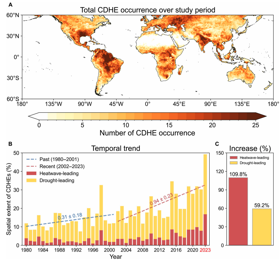
Heatwave-led events have been the main contributor to this increase, the study says, with their spatial extent rising 110% between 1980-2001 and 2002-23, compared to a 59% increase for drought-led events.
The map below shows the global distribution of CDHEs over 1980-2023. The charts show the percentage of the land surface affected by a heatwave-led CDHE (red) or a drought-led CDHE (yellow) in a given year (left) and relative increase in each CDHE type (right).
The study finds that CDHEs have occurred most frequently in northern South America, the southern US, eastern Europe, central Africa and south Asia.
Threshold passed
The authors explain that the increase in heatwave-led CDHEs is related to rising global temperatures, but that this does not tell the whole story.
In the earlier 22-year period of 1980-2001, the study finds that the spatial extent of heatwave-led CDHEs rises by 1.6% per 1C of global temperature rise. For the more-recent period of 2022-23, this increases “nearly eightfold” to 13.1%.
The change suggests that the rapid increase in the heatwave-led CDHEs occurred after the global average temperature “surpasse[d] a certain temperature threshold”, the paper says.
This threshold is an absolute global average temperature of 14.3C, the authors estimate (based on an 11-year average), which the world passed around the year 2000.
Investigating the recent surge in heatwave-leading CDHEs further, the researchers find a “regime shift” in land-atmosphere dynamics “toward a persistently intensified state after the late 1990s”.
In other words, the way that drier soils drive higher surface temperatures, and vice versa, is becoming stronger, resulting in more heatwave-led compound events.
Daily data
The research has some advantages over other previous studies, Yeh says. For instance, the new work uses daily estimations of CDHEs, compared to monthly data used in past research. This is “important for capturing the detailed occurrence” of these events, says Yeh.
He adds that another advantage of their study is that it distinguishes the sequence of droughts and heatwaves, which allows them to “better understand the differences” in the characteristics of CDHEs.
Dr Meryem Tanarhte is a climate scientist at the University Hassan II in Morocco, and Dr Ruth Cerezo Mota is a climatologist and a researcher at the National Autonomous University of Mexico. Both scientists, who were not involved in the study, agree that the daily estimations give a clearer picture of how CDHEs are changing.
Cerezo-Mota adds that another major contribution of the study is its global focus. She tells Carbon Brief that in some regions, such as Mexico and Africa, there is a lack of studies on CDHEs:
“Not because the events do not occur, but perhaps because [these regions] do not have all the data or the expertise to do so.”
However, she notes that the reanalysis data used by the study does have limitations with how it represents rainfall in some parts of the world.
Compound impacts
The study notes that if CDHEs continue to intensify – particularly events where heatwaves are the precursors – they could drive declining crop productivity, increased wildfire frequency and severe public health crises.
These impacts could be “much more rapid and severe as global warming continues”, Yeh tells Carbon Brief.
Tanarhte notes that these events can be forecasted up to 10 days ahead in many regions. Furthermore, she says, the strongest impacts can be prevented “through preparedness and adaptation”, including through “water management for agriculture, heatwave mitigation measures and wildfire mitigation”.
The study recommends reassessing current risk management strategies for these compound events. It also suggests incorporating the sequences of drought and heatwaves into compound event analysis frameworks “to enhance climate risk management”.
Cerezo-Mota says that it is clear that the world needs to be prepared for the increased occurrence of these events. She tells Carbon Brief:
“These [risk assessments and strategies] need to be carried out at the local level to understand the complexities of each region.”




The post Heatwaves driving recent ‘surge’ in compound drought and heat extremes appeared first on Carbon Brief.
Heatwaves driving recent ‘surge’ in compound drought and heat extremes
Greenhouse Gases
DeBriefed 6 March 2026: Iran energy crisis | China climate plan | Bristol’s ‘pioneering’ wind turbine
Welcome to Carbon Brief’s DeBriefed.
An essential guide to the week’s key developments relating to climate change.
This week
Energy crisis
ENERGY SPIKE: US-Israeli attacks on Iran and subsequent counterattacks across the Middle East have sent energy prices “soaring”, according to Reuters. The newswire reported that the region “accounts for just under a third of global oil production and almost a fifth of gas”. The Guardian noted that shipping traffic through the strait of Hormuz, which normally ferries 20% of the world’s oil, “all but ground to a halt”. The Financial Times reported that attacks by Iran on Middle East energy facilities – notably in Qatar – triggered the “biggest rise in gas prices since Russia’s full-scale invasion of Ukraine”.
‘RISK’ AND ‘BENEFITS’: Bloomberg reported on increases in diesel prices in Europe and the US, speculating that rising fuel costs could be “a risk for president Donald Trump”. US gas producers are “poised to benefit from the big disruption in global supply”, according to CNBC. Indian government sources told the Economic Times that Russia is prepared to “fulfil India’s energy demands”. China Daily quoted experts who said “China’s energy security remains fundamentally unshaken”, thanks to “emergency stockpiles and a wide array of import channels”.
‘ESSENTIAL’ RENEWABLES: Energy analysts said governments should cut their fossil-fuel reliance by investing in renewables, “rather than just seeking non-Gulf oil and gas suppliers”, reported Climate Home News. This message was echoed by UK business secretary Peter Kyle, who said “doubling down on renewables” was “essential” amid “regional instability”, according to the Daily Telegraph.
China’s climate plan
PEAK COAL?: China has set out its next “five-year plan” at the annual “two sessions”