

It is well understood that human-caused climate change is causing sea levels to rise around the world.
Since 1901, global sea levels have risen by at least 20cm – accelerating from around 1mm a year for much of the 20th century to 4mm a year over 2006-18.
Sea level rise has significant environmental and social consequences, including coastal erosion, damage to buildings and transport infrastructure, loss of livelihoods and ecosystems.
The Intergovernmental Panel on Climate Change (IPCC) has said it is “virtually certain” that sea level will continue to rise during the current century and beyond.
But what is less clear is exactly how quickly sea levels could climb over the coming decades.
This is largely due to challenges in calculating the rate at which land ice in Antarctica – the world’s largest store of frozen freshwater – could melt.
In this article, we unpack some of the reasons why projecting the speed and scale of future sea level rise is difficult.
Drivers of sea level rise
There are three principal components of sea level rise.
First, as the ocean warms, water expands. This process is known as thermal expansion, a comparatively straightforward physical process.
Second, more water gets added to the oceans when the ice contained in glaciers and ice sheets on land melts and flows into the sea.
Third, changes in rainfall and evaporation – as well as the extraction of groundwater for drinking and irrigation, drainage of wetlands and construction of reservoirs – affect how much water is stored on land.
In its sixth assessment cycle (AR6), the IPCC noted that thermal expansion and melting land ice contributed almost equally to sea level rise over the past century. Changes in land water storage, on the other hand, played a minor role.
However, the balance between these three drivers is shifting.
The IPCC projects that the contribution of melting land ice – already the largest contributor to sea level rise – will increase over the coming decade as the world continues to warm.
The lion’s share of the Earth’s remaining land ice – 88% – is in Antarctica, with Greenland accounting for almost all of the rest. (Mountain glaciers in the Himalaya, Alps and other regions collectively account for less than 1% of total land ice.)
However, it is difficult to project exactly how much Antarctic ice will make its way into the sea between now and 2100.
As a result, IPCC projections cover a large range of outcomes for future sea level rise.
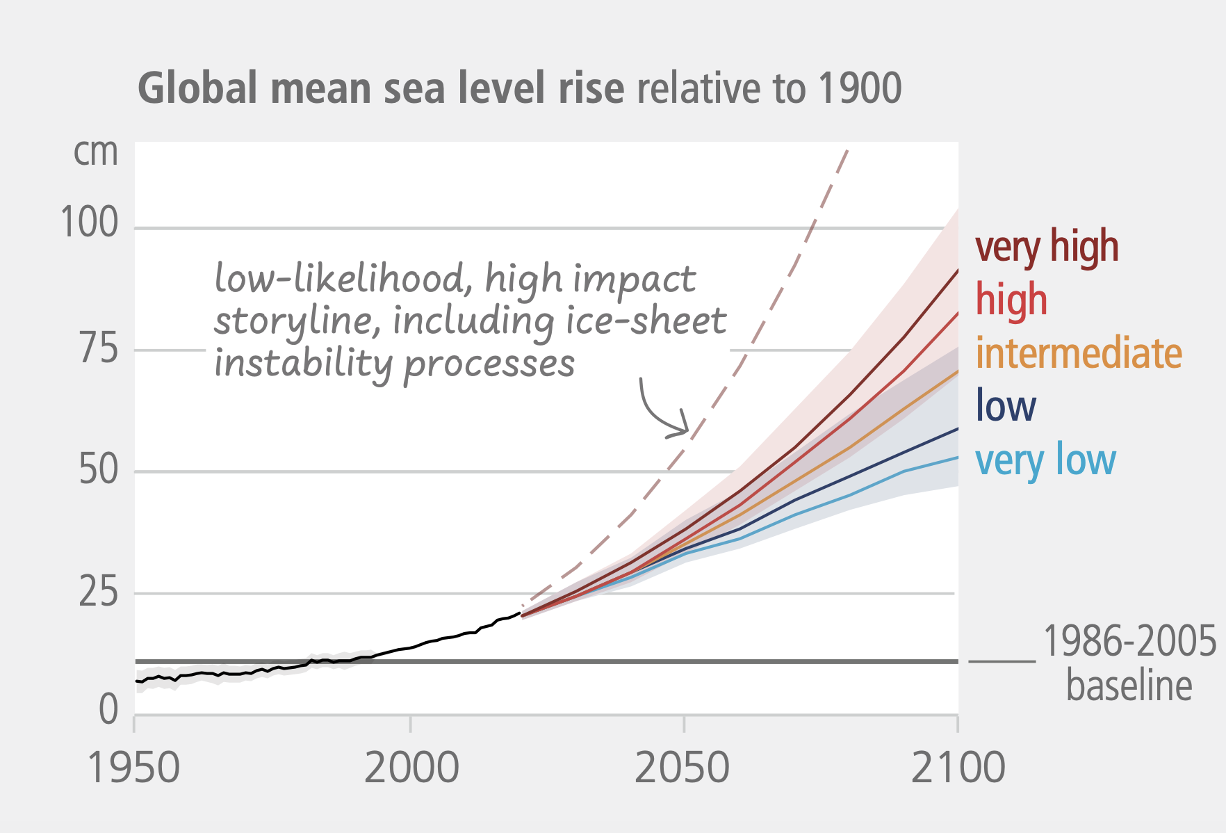
In AR6, the IPCC said sea levels would “likely” be between 44-76cm higher by 2100 than the 1995-2014 average under a medium-emissions scenario. However, it noted that sea level rise above this range could not be ruled out due to “deep uncertainty linked to ice sheet processes”.
The chart below illustrates the wide range of sea level rise projected by the IPCC under different warming scenarios (coloured lines) as well as a possible – but unlikely – worst-case scenario (dotted line).
The shaded areas represent the “likely range” of sea level rise under each warming scenario, calculated by analysing processes that are already well understood. The worst-case scenario dotted line represents a future where various poorly understood processes combine to lead to a very rapid increase in sea levels.
The graph shows that sea level rise increases with warming – and would climb most sharply under the “low-likelihood, high-impact” pathway.
Retreat of glacier grounding lines
In Antarctica, the melting of ice on the surface of glaciers is limited. In many locations, warmer temperatures are leading to increases in snowfall and greater snow accumulation, which means the surface of the ice is continuously gaining mass.
Most of Antarctica’s contribution to global sea level rise is, therefore, not linked to ice melt at the surface. Instead, it occurs when giant glaciers push from land into the sea, propelled downhill by gravity and their own immense weight.
These huge masses of ice first grind downhill across the land and then along the seafloor. Eventually, they detach from the bedrock and start to float.
These floating ice shelves then largely melt from below, as warm ocean water intrudes into cavities on its underside. This is known as “basal melting”.
The boundary between grounded and floating ice is known as the “grounding line”.
In many regions of Antarctica, grounding lines typically sit at the high point of the bedrock, with the ice sheet deepening inland. This is illustrated in the graphic below.
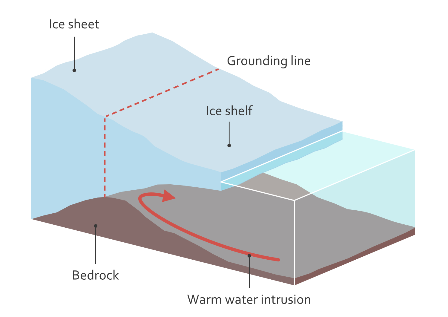
When a grounding line is at a high point of the bedrock, it acts as a block which limits the area of ice exposed to basal melting.
However, if the grounding line retreats further inland, warm water could “spill” over the high point in the bedrock and carve out large cavities below the ice. This could dramatically accelerate the retreat of grounding lines further inland across Antarctica.
There is evidence to suggest that the retreat of grounding lines might cause a runaway effect, in which each successive retreat causes the ice behind the line to detach from the land even more quickly.
Recent climate modelling suggests that many grounding lines are not yet in runaway retreat – but some regions of Antarctica are close enough to thresholds that tiny increases in basal melting push model runs toward very different outcomes.
Whether – and to what extent – grounding lines might retreat will depend on a wide range of factors, including the exact shape of the bedrock beneath the ice. However, the bedrock on the coast of Antarctica has not yet been precisely mapped in many places.
Ice shelves
Once Antarctic ice detaches from the seabed, it floats on the ocean surface. These floating ice shelves slow the flow of ice from land towards the sea, acting as a brake as they wedge between headlands and little hills on the seafloor.
If these ice shelves break apart, the flow of glaciers towards the sea can accelerate.
The image below on the left shows a present-day ice shelf that is pinned in place by bedrock, which slows the flow of the ice into the sea.
The image on the right shows a future scenario in which ocean water continues to intrude under the ice, accelerating basal melting on the underside of the floating ice until it completely detaches from the “pinning point” that had previously held it in place.
In this scenario, the bedrock is no longer acting as a break on glaciers pushing to the sea and the ice shelf starts flowing into the sea more quickly and begins breaking up. Ice masses inland then begin to push more rapidly towards the sea.
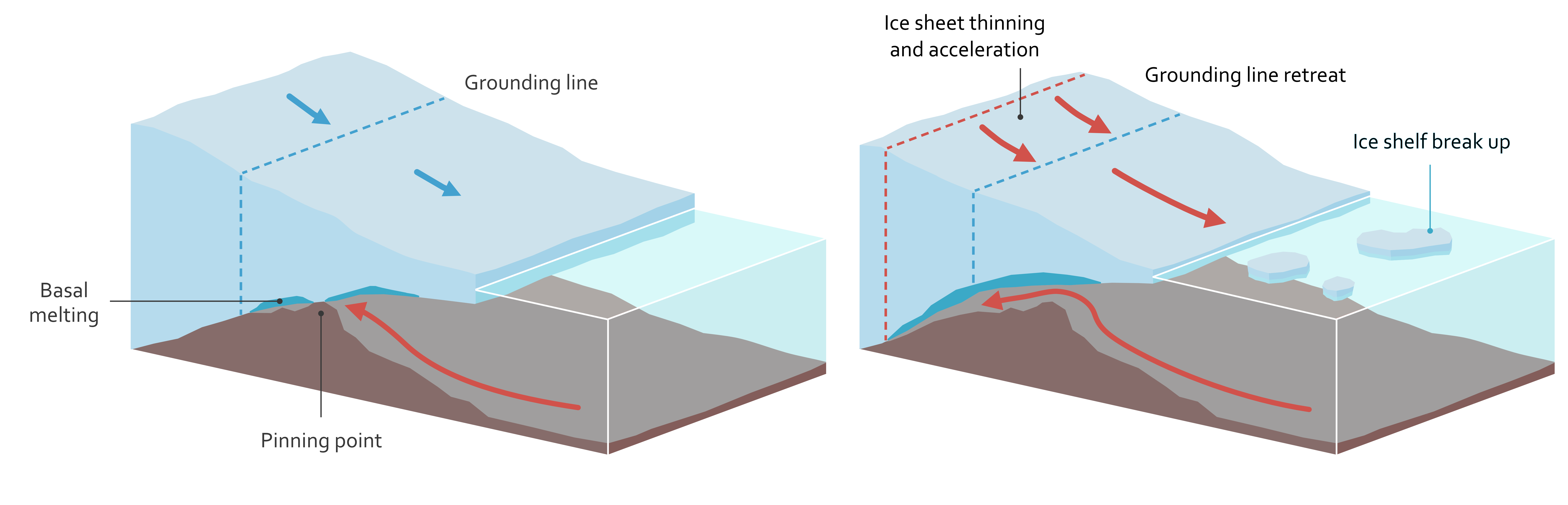
This dynamic was directly observed during the collapse of the Larsen-B ice shelf on the Antarctic Peninsula in 2002, which led to accelerated glacial ice flow and is believed to have contributed to a dramatic glacial retreat two decades later.
However, the factors affecting the stability of the floating ice shelves around Antarctica’s coast are complex. The strength of ice shelves depends on their thickness, how and where they are pinned to the seafloor, how cracks grow, as well as air and sea temperatures and levels of snow and rainfall. For example, meltwater at the surface can lever cracks further apart, in a process known as hydrofracturing.
A 2024 review of the stability of ice shelves found big gaps in scientific understanding of these processes. There is currently no scientific consensus on how rapidly various ice shelves might collapse – the pace is likely to vary greatly from one ice shelf to the next.
Ice-cliff collapse
If, and when, ice shelves collapse and drift away from the coast, they will expose the towering ice cliffs that loom behind them directly to the sea. These ice cliffs can be more than 100 metres tall.
This exposure could potentially lead to those cliffs to become structurally unstable and collapse in a runaway process – further accelerating the advance of the glaciers pushing towards the sea.
The images below illustrate how such a collapse might unfold. In the top image, a floating ice shelf buttresses the ice masses behind it. In the middle image, the ice shelf has largely broken apart and melted into the sea. In the bottom image, the ice shelf has completely disappeared, leaving a steep wall of ice towering over the sea. At this point, the exposed cliffs might collapse and crash into the water below.
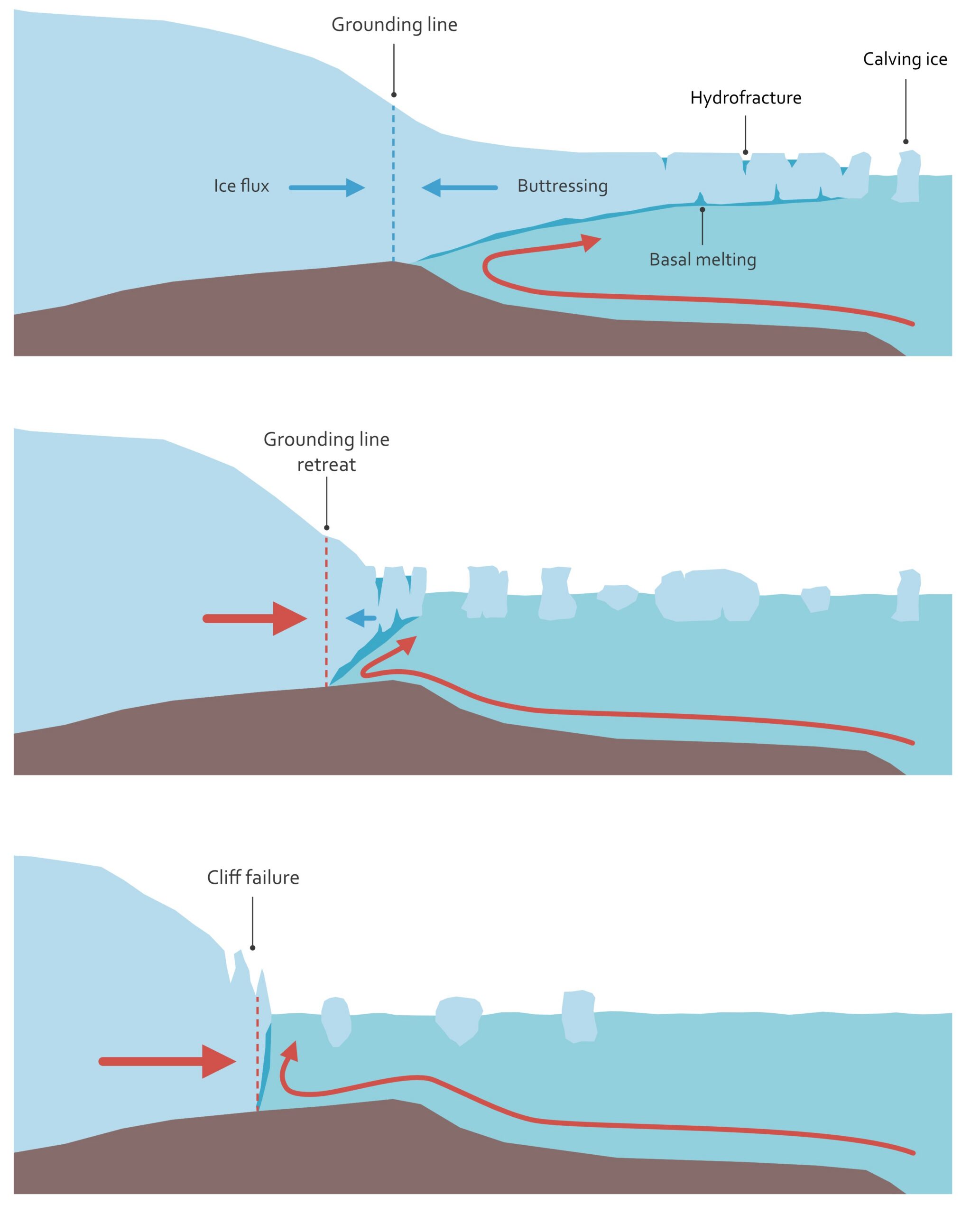
Researchers are still debating whether or not this “marine ice cliff instability” is likely to happen this century.
Modelling ocean dynamics
The speed at which grounding lines retreat, ice shelves collapse and ice cliffs cascade into the sea partially depends on complex ocean dynamics.
The temperature and speed of water intrusion underneath the ice depends on multiple factors, including ocean currents, winds, sea ice, underwater ridges and eddies. These factors vary from one location to the next and can vary by season and by year.
Once water reaches a given cavity, the ways in which turbulent flows and fresh meltwater plumes meet the ice can significantly affect melt levels – further complicating the picture.
In other words, predicting future melt depends on models that integrate macro-level ocean circulation with local-level turbulence. This remains a major modelling challenge that, despite ongoing progress, is unlikely to be conclusively resolved any time soon.
Planning for future sea level rise
Scientists agree that human-caused climate change is causing sea levels to rise and that the oceans will continue to rise during the current century and far beyond.
However, the combination of the complexity of modelling ice-ocean interactions and the threat of potential runaway processes means that, for the foreseeable future, there is considerable uncertainty about the magnitude of future sea level rise.
(While this article focuses on Antarctica, it is worth noting that Greenland’s contribution to future sea level rise is also highly uncertain.)
To complicate matters further, the ocean does not rise like water in a bathtub, creeping up equally on all sides. Instead the Earth’s surface is highly dynamic.
For example, during the last ice age, the immense mass of the glaciers that covered much of northern Europe pressed the Earth’s surface downwards. Even though most of that ice disappeared millennia ago, much of Scandinavia is still rebounding today, causing the land to rise gradually.
In contrast, the city of Jakarta in Indonesia is sinking at a rapid pace of 10cm per year due to sprawling urbanisation and extraction of groundwater for household and industrial uses. That rate may increase or decrease over the coming decades, depending on urban planning and water management decisions.
This mix of natural and human-driven factors means that, even if researchers could perfectly predict average global sea level rise, calculating how much the sea will rise in any given location will remain challenging.
Another key unknown is around future levels of human-caused greenhouse gas emissions which drive climate change.
The scientific community is working to better understand the dynamics driving sea level rise and improve predictions, including through Antarctic sea bed mapping, field observations and improved models. Those advances in knowledge will not erase uncertainty, but they could reduce the range of possible outcomes.
Nevertheless, while that range may narrow, it will not completely disappear.
Plans drawn up by policymakers and engineers to prepare society for future sea level rise should never be based on a single point estimate.
Instead, they should take into account a range of possible “likely” outcomes – and include contingency plans for less likely, but entirely possible, scenarios in which the oceans rise far faster than currently expected.


The post Guest post: The challenges in projecting future global sea levels appeared first on Carbon Brief.
Guest post: The challenges in projecting future global sea levels

June Rubis is a steering group committee member for the Cali Fund, from Sarawak in Malaysian Borneo.
At COP16 in Cali, governments made a significant commitment: at least half of the funding from the new Cali Fund should support the self-identified needs of Indigenous Peoples and local communities, including women and youth. It was a watershed moment for multilateral benefit-sharing.
The challenge now is to translate that commitment into access arrangements that recognise the different institutions, priorities and decision-making processes of Indigenous Peoples and local communities.
For generations, biodiversity and traditional Indigenous knowledge have provided significant value to companies who depend on nature’s genetic diversity to discover new drugs that fight diseases, create products that improve health, and grow crops resilient to extreme heat and flooding events. While some compounds are sampled directly from the source country, increasingly the digital blueprints are held in online public databases which are freely accessible to use for innovation and research.
Countries urged to ramp up “insufficient” nature policies at COP17
The Cali Fund was established at COP16 to encourage commercial users of Digital Sequence Information, or DSI, to share benefits arising from its use. Estimates suggest it could generate over $3.5 billion a year – a stark contrast to the modest $10,656 currently committed to the fund from just five SMEs, underlining how much progress must be made at COP17 over the next two weeks.
The COP16 decision that set up the fund offers two routes for money to reach Indigenous Peoples and local communities: through government authorities, and through direct payments to institutions identified by Indigenous Peoples and local communities themselves.
Varied ways of organising
Indigenous Peoples and local communities organise through a wide range of institutions. Some have national or regional organisations experienced in managing international grants. Others work through territorial organisations, customary institutions, community associations, cooperatives or networks. Some have professional finance teams and audited accounts; others have extensive experience governing territories, collective resources or conservation work without having been organised around international funding requirements.
For direct access, some questions are already apparent. Which institutions should be able to receive funds? How should they be identified? What fiduciary standards should apply? How should safeguards and accountability work where institutional capacities differ? What support may be needed where institutions have strong community mandates but less experience with international finance?
Comment: Protecting nature is a public duty, not a Wall Street profit opportunity
If access is designed mainly around institutions that already meet the expectations of large international finance mechanisms, early funding will tend to favour those already familiar to funders. They will gain further experience and become better positioned for future funding, while institutions with less administrative capacity may remain outside the system despite strong community mandates and long histories of stewardship.
These first decisions matter most, because they set the terms for everyone who follows.
The role of intermediaries requires care. Some Indigenous organisations may want a fiscal host to hold and manage funds on their behalf. Communities may choose to work through an NGO they trust. Government-facilitated arrangements may work well in particular national contexts.
What matters is the function an intermediary performs and the authority that comes with it. Providing administrative support is different from deciding which Indigenous organisations qualify, which priorities can receive support, or how success will be assessed. Direct access means communities keep that decision-making authority.
Decision-making power
The COP16 decision refers to institutions that Indigenous Peoples and local communities identify. But authority among Indigenous Peoples does not sit in one kind of body. It may sit with territorial organisations, customary institutions, community associations or combinations of these. Legal recognition and customary authority do not always align neatly.
Global deforestation slowed in 2025 but Brazil’s election could undo “fragile” gains
An important feature of the Cali Fund’s governance is that Indigenous Peoples and local communities participate as full members of the Steering Committee, rather than as observers. Seven Indigenous Peoples and local community representatives, one from each of the seven socio-cultural regions, participate in consensus-based decision-making alongside representatives of governments and UN entities. Six additional representatives from civil society, scientific institutions and the private sector participate as observers.
That representation carries responsibility. Institutional legitimacy, access and representation take different forms across the seven socio-cultural regions. Indigenous Peoples and local communities members therefore have an important role in bringing those differences into the Fund’s governance and in ensuring that arrangements developed for one context do not become the assumed model for everyone else.
Safeguards and clear responsibilities
COP17 can establish the core principles and direction, while allowing operational pathways to develop in ways that respond to different regional contexts. The decisions countries take in Yerevan will shape how that flexibility is realised in practice.
The choices made around access will influence which institutions are able to participate, which routes become established and which forms of authority are recognised within the funding architecture. The aim should be an architecture with enough structure to maintain confidence while allowing for different forms of Indigenous and community governance.
A credible direct-access pathway will need safeguards, financial oversight and clear responsibilities. This would give the 50% commitment a stronger institutional foundation.
The Cali Fund’s importance will ultimately depend not only on how much funding reaches Indigenous Peoples and local communities, but on whether they are able to determine how the money is accessed, governed and used. This requires access pathways that recognise their institutions, priorities and decision-making processes, rather than requiring them to conform to a single predetermined model.
The post COP17 must settle who decides how Cali Fund money is disbursed appeared first on Climate Home News.
COP17 must settle who decides how Cali Fund money is disbursed
The UK government has approved extraction at the Jackdaw gas field in the North Sea, despite acknowledging that this decision could make it harder for Britain to convince other countries to move away from fossil fuel production.
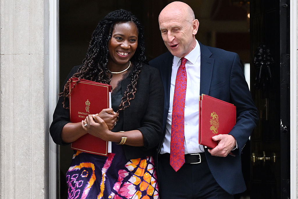
UK energy secretary Miatta Fahnbulleh approved the drilling on Wednesday after months of high-profile debate, fuelled in part by interventions from US President Donald Trump. She argued that the project would boost energy security in the wake of the Middle East fossil fuel crisis, protect hundreds of jobs and add £2.9 billion ($3.88bn) to the UK economy.
She said Jackdaw’s gas would be cleaner than imported gas and would not prevent the UK from meeting its legally-binding carbon targets and its goal of net zero by 2050. As the field is already licensed, she said extraction was consistent with the Labour Party’s 2024 manifesto promise not to issue any new oil and gas licenses.
The same morning, the government announced a new Energy Wealth Fund to reinvest oil and gas revenues in the climate transition. It will start with £2 billion ($2.67bn) from the government and be topped up over time with tax revenues from offshore oil and gas production.
Climate campaigners in the UK and abroad were quick to condemn the decision, while a leading legal expert told Climate Home News it goes against the advice of the International Court of Justice. Meanwhile, the government’s own documents reveal that it recognises the drilling could damage the UK’s reputation and its ability to push forward the global transition away from fossil fuels.
“Climate leadership” blow
The 92-page decision document says Fahnbulleh “acknowledges that international standing on climate is important and accepts that a decision to grant consent may not further the UK’s international climate leadership.”
It adds: “She acknowledges concerns about the potential implications for the UK’s credibility and influence – including the difficulty inherent in encouraging other states to move away from fossil fuel production while the UK continues, in a limited and transitional way, to draw on its own domestic resources.”
While noting that Jackdaw has not been issued with a new license – just permission to extract gas – the document says Fahnbulleh “accepts this does not fully resolve the underlying tension in the UK’s position” but “considers this alongside the substance of the UK’s wider record [on emissions reduction], which remains significant”.
It continues that she accepts these concerns are “legitimate” and weigh against approving gas extraction, but only gives this argument a “moderate negative weight” set against the benefits of gas production.
“Huge” wrong signal
In international climate talks, the UK has long supported the transition away from fossil fuels and is one of very few major oil and gas producers to ban new licenses. Across the North Sea, the Norwegian government continues to make offshore areas available for oil and gas exploration through annual licensing rounds.
Climate experts and campaigners shared the concern, acknowledged in the decision document, that approving Jackdaw could set a precedent for fossil fuel production elsewhere. Sam Fankhauser, professor of climate change economics at Oxford University, said the direct climate impact of Jackdaw is “much smaller than the debate around it would suggest” but the “wrong signal it sends, however, is huge”.
-
Carbon capture industry faces tough future, as UK raids green spending
Despite a spate of projects getting underway, the mood at an industry conference in London this week was low with government subsidies set to shrink -
Paris Agreement committee names three countries snubbing it over NDCs
More than 30 countries have failed to submit an NDC, but only three have repeatedly ignored the committee’s efforts to engage with them

