Climate Change
‘Simply staggering’: Rapidly developing ‘super El Niño’ on track to peak in December

The ongoing “super El Niño” is likely to peak at the end of 2026 and push average global temperatures to record levels next year.
That is according to Carbon Brief’s latest “state of the climate” update, which analyses El Niño forecasts from more than a dozen climate models, as well as six global temperature datasets.
Dr Zeke Hausfather, Carbon Brief’s climate science contributor, described this year’s El Niño as “simply staggering” when answering questions from CB+ members during a CB Connect “ask me anything” session.
El Niño is a naturally occurring climate pattern in the tropical Pacific that releases heat from the ocean into the atmosphere and temporarily boosts global temperatures.
This year’s El Niño event – which has been underway since June – has already broken a number of records and reshaped the world’s weather, fuelling fires in Indonesia and “super typhoons” in the west Pacific.
The strength of an El Niño is tracked using the “Niño3.4 anomaly”, which is a measure of how much warmer sea surface temperatures are than average in a section of the central Pacific.
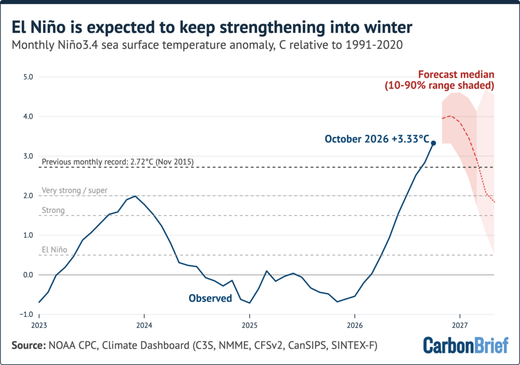
Analysis of more than 600 forecasts from 14 different climate models by Hausfather for Carbon Brief’s “state of the climate” update shows how models project this year’s El Niño will peak with an anomaly of around 4C. This would be more than a degree above the previous record in 2015-16.
Writing on CB Connect on 5 November, Hausfather wrote:
“This El Niño event is developing so quickly and is reaching sea surface temperatures so warm that it’s simply staggering. We haven’t seen anything like this in the historical record and it may end up being the strongest El Niño event in the past millennium.”
This year’s El Niño has already chalked up a number of milestones.
On 18 September, the daily anomaly in the Niño3.4 region broke the satellite-era record set in 2015 when it reached 3.11C.
Meanwhile, September as a whole recorded the highest monthly Niño3.4 region temperature anomaly – 2.84C – since sea surface temperature records began in the mid-1800s.


Membership
Support award-winning climate journalism
Hausfather wrote on CB Connect that this year’s El Niño had been “running well above any prior El Niño event since June, at times by a full degree [Celsius]”.
Carbon Brief’s “state of the climate” analysis indicates that El Niño is set to continue to intensify into December, with 10 out of 14 models expecting temperatures in the Niño3.4 region to peak in the final month of this year. The remainder anticipate a November peak.

While human emissions of greenhouse gases are responsible for almost all of long-term global warming, temperatures in specific years are strongly influenced by El Niño events.
The “state of the climate” analysis explains that this year’s El Niño event will have its largest effect on global temperatures in 2027. This is because global temperatures typically lag warming in the tropical Pacific by around three months.
Carbon Brief projects that the 2027 average global temperature will reach around 1.74C above pre-industrial levels. It calculates a 96% chance that next year will be the warmest on record.
This projection is based on the historical relationship between year-on-year temperature changes and El Niño conditions the preceding autumn. It also factors in uncertainty around how global temperatures will develop across the remainder of 2026.




The post ‘Simply staggering’: Rapidly developing ‘super El Niño’ on track to peak in December appeared first on Carbon Brief.
‘Simply staggering’: Rapidly developing ‘super El Niño’ on track to peak in December